
Municipality of East Samos
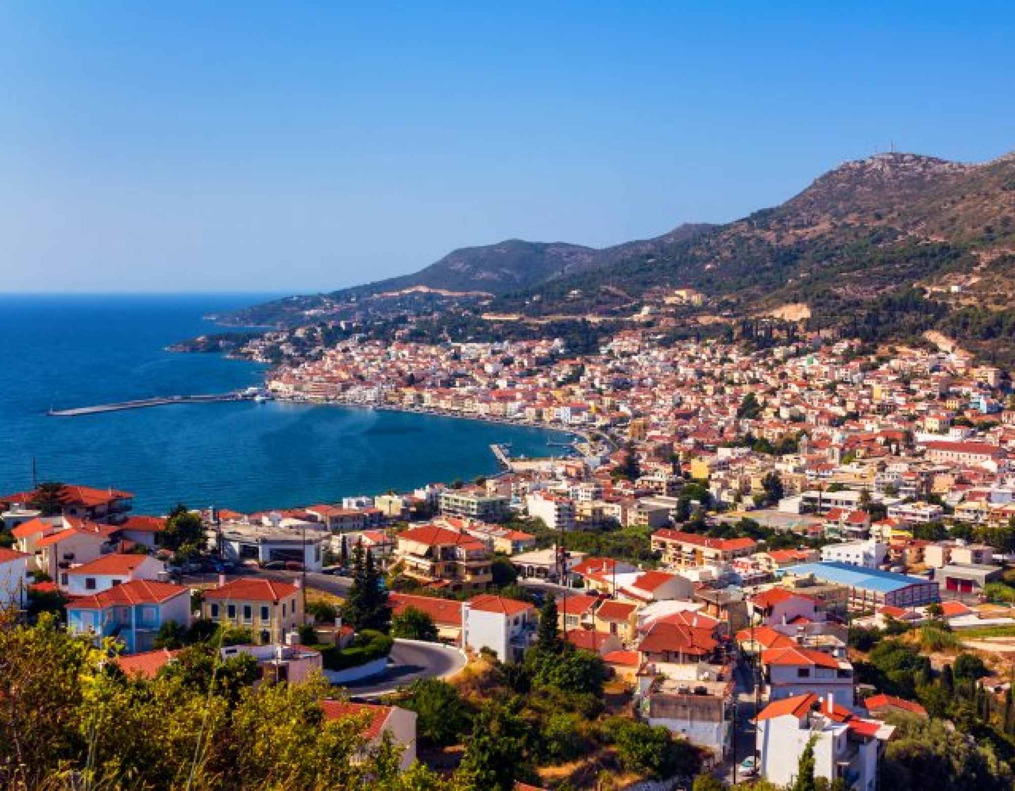
🏛️ Municipality of Eastern Samos – From the Town of Samos to Pythagoreio and the Heraion
The Municipality of Eastern Samos covers the eastern and southeastern part of the island and is one of the two municipalities of Samos. Its administrative boundaries include the town of Samos, Vathy, Pythagoreio, Kokkari, Mytilinioi, Chora, Ireon and dozens of coastal, lowland and mountain settlements.
The area contains the island’s administrative centre, its main airport, two important ports, the General Hospital, public services, commercial activities and some of the most significant monuments of ancient Samos.
The municipality has a particularly diverse character. It includes the densely built town of Samos, tourist settlements such as Pythagoreio and Kokkari, fertile plains, vineyards, mountain villages on the slopes of Mount Ampelos and an extensive coastline with both organised and isolated beaches.
📍 Geographical location and character
The Municipality of Eastern Samos extends from the northern coast and the slopes of Mount Ampelos, also known as Karvounis, to the lowland areas of Chora and the southern coastline of Pythagoreio, Potokaki, Ireon and Spatharaioi.
To the east lies the coast of Asia Minor, separated from Samos by the narrow Mykale Strait. To the west, the municipality borders the Municipality of Western Samos, while to the north and south it is surrounded by the Aegean Sea.
Its total area is approximately 292.556 square kilometres. The terrain changes considerably, ranging from coastal zones and plains to forested slopes, ravines and mountain villages on Karvounis.
🏛️ Establishment and administrative identity
The Municipality of Eastern Samos was officially established on 9 March 2019, following the division of the unified Municipality of Samos into the Municipality of Eastern Samos and the Municipality of Western Samos.
The administrative change was implemented under Law 4600/2019 and published in Government Gazette 43/A/9-3-2019. The settlement of Samos, meaning the town of Samos, was designated as the municipal seat, while Pythagoreio was designated as the historic seat.
The municipality belongs to the Regional Unit of Samos in the North Aegean Region and includes the Municipal Units of Vathy and Pythagoreio.
🗺️ Municipal Unit of Vathy
The Municipal Unit of Vathy covers mainly the northeastern part of the municipality and includes the town of Samos, Vathy, important coastal destinations and mountain villages on the northern slopes of Mount Ampelos.
It includes nine communities:
✅ Community of Samioi: The town of Samos and the settlements of the wider area
✅ Community of Vathy: Vathy and the surrounding neighbourhoods
✅ Community of Agios Konstantinos: Agios Konstantinos and Valeontades
✅ Community of Ampelos: Ampelos, Livadaki and Petalides
✅ Community of Vourliotes: Vourliotes, Avlakia, Kampos and the Monastery of Vronta
✅ Community of Kokkari: Kokkari
✅ Community of Manolates: Manolates and Margarites
✅ Community of Palaiokastro: Palaiokastro, Klima, Posidonio, Psili Ammos and other smaller settlements
✅ Community of Stavrinides: Stavrinides
The Municipal Unit of Vathy covers an area of approximately 126.921 square kilometres.
🗺️ Municipal Unit of Pythagoreio
The Municipal Unit of Pythagoreio covers the southeastern, central and part of the southern sector of the municipality. It includes the ancient city of Samos, the airport, the Chora plain, Ireon and many inland villages.
It includes eleven communities:
✅ Community of Pythagoreio: Pythagoreio, Nea Poli, Pountes and Karpovoulos
✅ Community of Mytilinioi: Mytilinioi, Kamara, Rizovrachos and other settlements
✅ Community of Pagondas: Pagondas, Ireon and Kolona
✅ Community of Chora: Chora and Potokaki
✅ Community of Koumaradei: Koumaradei and the Monastery of Megali Panagia
✅ Community of Mavratzaioi: Mavratzaioi, Gionides and the Monastery of Timios Stavros
✅ Community of Mesogeio: Mesogeio
✅ Community of Myloi: Myloi
✅ Community of Pandrosos: Pandrosos
✅ Community of Pyrgos: Pyrgos
✅ Community of Spatharaioi: Spatharaioi and the coastal or smaller settlements of the community
In total, the Municipality of Eastern Samos includes twenty communities and a large number of officially registered settlements and islets.
👥 Population and settlement distribution
According to the results of the 2021 Population Census, the Municipality of Eastern Samos has 20,021 permanent residents. In 2011, the corresponding population of the two present-day municipal units was 20,513 residents.
The population is not distributed evenly. The largest concentration of residents and services is found in the town of Samos, Vathy, Mytilinioi, Pythagoreio, Kokkari and Chora.
By contrast, several mountain villages and small coastal settlements have limited permanent populations and show strong seasonal variation. During the summer months, tourist areas become significantly busier because of visitors, seasonal workers and owners of holiday homes.
🏙️ The town of Samos and Vathy
The official seat of the municipality is the settlement of Samos, historically known as Limen Vatheos or Kato Vathy. The name “Samos” was officially established in 1958.
Vathy is a separate and older settlement, built amphitheatrically on the hillsides above the town. As the built-up area expanded, the two settlements almost merged, and in everyday usage the entire urban area is often referred to as “Vathy”.
The town of Samos contains the town hall, administrative services, shops, banks, restaurants, the port and a large proportion of the island’s services. Old Vathy preserves dense traditional architecture, tiled roofs, narrow uphill streets and panoramic views over the bay of the same name.
⚓ The ports of Samos and Pythagoreio
Two of the island’s principal ports lie within the municipality:
✅ Port of Samos – Vathy: Serves passenger, commercial and ferry traffic and is the main maritime gateway on the eastern side of the island.
✅ Port of Pythagoreio: Serves passenger, tourist, fishing and private vessels, while the wider harbour area is closely connected with the modern tourism activity of Pythagoreio.
The area also includes a marina, tourist shelters, fishing shelters and small anchorages. Exact ferry and international routes change according to the season and should be checked before every journey.
✈️ Samos International Airport “Aristarchos of Samos”
Samos International Airport “Aristarchos of Samos” is located in the lowland area west of Pythagoreio, close to Chora and Potokaki.
It lies approximately 14 kilometres from the town of Samos and has operated since 1963. It includes a passenger terminal, air traffic control facilities, passenger services, food outlets, parking areas and car rental companies.
It serves domestic and international flights, with a significant increase in traffic during the summer season. It is connected by road and bus services with the town of Samos, Pythagoreio and other areas.
🚌 Road network and public transport
The main road route connects the town of Samos with Kokkari and the northern coast, while separate routes lead towards Mytilinioi, Chora, the airport, Pythagoreio and Ireon.
The mountain communities of Ampelos and the inland areas are served by roads with continuous bends, narrower sections and considerable changes in elevation. Particular care is required on routes towards Vourliotes, Manolates, Ampelos, Stavrinides and Pandrosos.
Intercity buses connect the town of Samos with major settlements and the airport. The frequency of services varies depending on the season, so visitors should consult the current timetable.
For exploring mountain villages, smaller beaches and remote locations, a car remains the most flexible option.
🏥 Services, healthcare and administrative structures
The town of Samos is the main administrative and service centre for the entire island.
The Municipality of Eastern Samos includes:
✅ The Town Hall of Eastern Samos
✅ The General Hospital of Samos “Agios Panteleimon”
✅ Primary healthcare facilities
✅ Judicial and public prosecution services
✅ Police and Fire Services
✅ Port Authority and customs services
✅ Services of the Regional Authority and Decentralised Administration
✅ Citizen Service Centres
✅ Primary and secondary schools
✅ Vocational, cultural and social facilities
The General Hospital of Samos belongs to the 2nd Regional Health Authority of Piraeus and the Aegean and serves residents and visitors from the entire island.
🏛️ Ancient Samos and the historical significance of the area
Eastern Samos formed the centre of the political, commercial, naval and cultural development of the ancient Samian state.
The ancient city of Samos was located on the site of present-day Pythagoreio. During the 6th century BC, particularly under the rule of Polycrates, it developed into one of the most important naval and commercial powers of the eastern Mediterranean.
Important figures associated with the area include:
✅ The mathematician and philosopher Pythagoras
✅ The astronomer Aristarchos of Samos
✅ The philosopher Epicurus
✅ The engineer Eupalinos of Megara
✅ The architects and sculptors Rhoikos and Theodoros
The archaeological remains demonstrate the high level of technical, artistic and economic development achieved by ancient Samos.
🌍 Pythagoreio and the Heraion – UNESCO World Heritage Sites
Pythagoreio and the Heraion were jointly inscribed on the UNESCO World Heritage List in 1992.
The protected area includes the ancient fortified city, the Polycratian Walls, the Tunnel of Eupalinos, Hellenistic and Roman monuments and the Sanctuary of Hera.
The Tunnel of Eupalinos is an underground aqueduct 1,036 metres long, excavated during the 6th century BC from two opposite sides of the mountain. It is one of the most significant engineering achievements of antiquity.
The Heraion was located approximately six kilometres from the ancient city and was connected to it through the Sacred Way. The great Temple of Hera was designed as a colossal structure with 155 columns approximately 20 metres high.
🏺 Museums and cultural monuments
The Municipality of Eastern Samos contains important museums and monuments from different historical periods:
✅ The Archaeological Museum of Samos in the town of Samos
✅ The Archaeological Museum of Pythagoreio
✅ The Tunnel of Eupalinos
✅ The Archaeological Site of the Heraion
✅ The Polycratian Walls
✅ The Ancient Theatre of Pythagoreio
✅ The Roman Baths
✅ The Tower of Lykourgos Logothetis
✅ The Castle of Pythagoreio
✅ The Tower of Sarakini
✅ The Ecclesiastical and Byzantine Museum of Samos
✅ The monasteries of Megali Panagia, Timios Stavros and Agia Triada
The Archaeological Museum of Pythagoreio presents approximately 3,000 objects dating from the 4th millennium BC to the 7th century AD. The Archaeological Museum of Samos contains important finds from the Heraion, including the colossal Kouros of Samos.
🏘️ Coastal and tourist settlements
The Municipality of Eastern Samos includes several of the island’s best-known coastal destinations:
✅ Pythagoreio: Historic and tourist settlement built over the ancient city of Samos
✅ Kokkari: Coastal settlement with a small harbour, tourism facilities and a large pebbled beach
✅ Ireon: Coastal settlement near the Sanctuary of Hera
✅ Potokaki: Tourist area with an extensive beach close to the airport
✅ Psili Ammos: Coastal settlement with a sandy beach and shallow waters
✅ Posidonio: Small sheltered bay overlooking the coast of Asia Minor
✅ Klima: Quiet coastal settlement on the eastern side
✅ Avlakia: Small coastal settlement on the northern coast
✅ Agios Konstantinos: Coastal settlement on the northern lower slopes of Mount Ampelos
These areas experience increased tourism activity during the summer months, while several retain a quieter character outside the peak season.
⛰️ Mountain and traditional villages
Historic villages with different architectural styles and local identities are found on the slopes of Mount Ampelos and in the inland areas:
✅ Vourliotes
✅ Manolates
✅ Ampelos
✅ Stavrinides
✅ Pandrosos
✅ Pyrgos
✅ Koumaradei
✅ Mavratzaioi
✅ Mesogeio
✅ Myloi
✅ Pagondas
✅ Spatharaioi
Many of these villages preserve stone houses, tiled roofs, narrow streets, small squares, churches, traditional cafés and views over the Aegean Sea.
Vourliotes and Manolates are well-known destinations on the northern slopes of Karvounis, while Pandrosos, Pyrgos and Spatharaioi offer different views of the mountainous and southern inland areas.
🌊 Beaches and coastline
The municipality’s coastline includes beaches with sand, pebbles, deep or shallow waters and different levels of organisation.
On the northern coast, the main beaches include:
✅ Kokkari Beach – Tarsanas
✅ Lemonakia
✅ Tsamadou
✅ Tsampou
✅ Avlakia
✅ Agios Konstantinos
✅ Livadaki of Ampelos
✅ Petalides
On the eastern and southeastern coast are:
✅ Livadaki
✅ Kerveli
✅ Mikri Lakka
✅ Megali Lakka
✅ Mourtia
✅ Klima
✅ Posidonio
✅ Psili Ammos
✅ Mykali
On the southern coast are:
✅ Potokaki
✅ Pythagoreio Beach
✅ Ireon Beach
✅ Papa Beach
✅ Small coastal areas of Spatharaioi
The northern beaches are more exposed to the meltemi winds and may experience strong waves. The southern and eastern coasts have different orientations and often offer calmer conditions, always depending on the wind.
🌲 Mount Ampelos – Karvounis
Mount Ampelos, also known as Karvounis, is the main mountain massif of eastern and central Samos.
Its slopes are covered with pine forests, chestnut trees, vineyards, olive groves and Mediterranean vegetation. Springs, streams, ravines and old footpaths connect the villages with cultivated areas and the coast.
The wider area includes routes towards Vourliotes, Manolates, Ampelos, Stavrinides, Pandrosos and the higher sections of the mountain.
Part of the mountain massif is protected under the Natura 2000 network with the code GR4120002 “Mount Ampelos – Karvounis”.
🦩 Psili Ammos Salt Marsh and protected areas
The Psili Ammos Salt Marsh is one of the most important coastal wetlands of eastern Samos.
The area lies west of the settlement of Psili Ammos and is included in protected zones of the Natura 2000 network. It is a resting and feeding site for migratory and water birds.
The municipality’s administrative boundaries also include:
✅ The protected area of the Psili Ammos Salt Marsh
✅ Sections of Mount Ampelos – Karvounis
✅ The Wildlife Refuge in the Argyrou – Psili Ammos area
✅ The Aspros Vrachos – Dendrias Wildlife Refuge
✅ The Mesokampos wetland
✅ The mouth of the Imbrasos River near Ireon
✅ Smaller coastal and seasonal wetlands
These areas require low-impact visits, avoidance of noise and respect for vegetation and wildlife.
🍇 Agriculture, viticulture and local production
Despite the development of tourism and services, agriculture remains an important part of the economic and cultural identity of eastern Samos.
The white Muscat grape of Samos is cultivated on the slopes of Mount Ampelos, often on terraces that retain the soil on steep hillsides.
Other crops grown in the lowland and semi-mountainous areas include:
✅ Olives
✅ Citrus fruits
✅ Grapevines
✅ Vegetables
✅ Fruit trees
✅ Aromatic plants
Beekeeping, olive oil production and small-scale local products complete the agricultural activity.
🍽️ Gastronomy and local flavours
Local cuisine is based on products from the Samian land and sea.
Tavernas and restaurants in the area commonly serve:
✅ Fresh fish and seafood meze
✅ Goat and meat prepared with local recipes
✅ Chickpea fritters
✅ Stuffed vine leaves
✅ Samian bourek
✅ Local cheeses
✅ Honey and almond-based sweets
✅ Souma
✅ Samian ouzo
✅ Sweet and dry Muscat wines
Coastal settlements offer a wider selection of fish and seafood, while mountain villages feature dishes connected with livestock farming, vegetables and agricultural production.
🎭 Culture and events
Throughout the year, the area hosts local festivals, religious celebrations, concerts, theatrical performances, exhibitions, sporting events and activities connected with the history and traditions of Samos.
Important events include:
✅ Cultural events in Pythagoreio
✅ Summer events in the town of Samos
✅ The Ireon Music Festival
✅ Traditional festivals in the mountain villages
✅ Events related to Samian wine and local production
✅ Religious celebrations in the communities
✅ Music and theatre performances in outdoor venues
Programmes and dates change every year and should be confirmed before visiting.
🌿 What to see
During your exploration of the Municipality of Eastern Samos, look for:
✅ The town of Samos and the waterfront avenue
✅ Old Vathy and its traditional neighbourhoods
✅ Pythagoreio and its historic harbour
✅ The Tunnel of Eupalinos
✅ The Polycratian Walls
✅ The Tower of Lykourgos Logothetis
✅ The Archaeological Museum of Pythagoreio
✅ The Archaeological Museum of Samos
✅ The Sanctuary of Hera
✅ The Tower of Sarakini
✅ Kokkari and its small harbour
✅ Vourliotes and Manolates
✅ Ampelos and Stavrinides
✅ Psili Ammos and the protected salt marsh
✅ The beaches of Tsamadou, Tsampou, Mykali and Potokaki
✅ The monasteries of Megali Panagia and Timios Stavros
✅ The villages of Pagondas, Pyrgos, Pandrosos and Spatharaioi
🚗 Suggested routes
The large area and variety of the municipality allow for several different day routes:
✅ Town of Samos – Vathy – Palaiokastro – Psili Ammos: Combines urban exploration, a traditional settlement and a beach.
✅ Town of Samos – Kokkari – Lemonakia – Tsamadou: Coastal route along the northern coast.
✅ Kokkari – Vourliotes – Manolates – Ampelos: Route towards the mountain villages and the slopes of Karvounis.
✅ Pythagoreio – Tunnel of Eupalinos – Chora – Mytilinioi: Historical and cultural route through southeastern Samos.
✅ Pythagoreio – Potokaki – Ireon – Sanctuary of Hera: Combination of beaches, settlements and archaeological monuments.
✅ Myloi – Koumaradei – Pyrgos – Pandrosos: Inland route through villages, monasteries and natural landscapes.
🚶 Visitor experience
The Municipality of Eastern Samos cannot be meaningfully explored in a single day. At least two to three days are required for an initial introduction, while a longer stay is needed for a more complete exploration of the beaches, villages and archaeological sites.
The main urban and coastal settlements can be explored on foot. A vehicle is required for inland villages, mountain routes and smaller coastal areas.
Distances are not always long, but mountain roads, bends and summer traffic increase travel times.
📆 When to visit
Spring: Ideal for hiking, mountain villages, archaeological sites and flowering landscapes.
Summer: The liveliest season, with tourism businesses fully operational, more sea activities and cultural events.
Autumn: Suitable for quiet routes, swimming at the beginning of the season, photography and exploring the villages.
Winter: Offers a more authentic picture of local life, although many tourist businesses and seasonal services remain closed.
Morning: The best time for archaeological sites and beaches with limited shade.
Afternoon and evening: Ideal for the town of Samos, Pythagoreio, Kokkari and coastal walks.
🧭 Access to the Municipality of Eastern Samos
Access is possible:
✅ By air through Samos International Airport
✅ By ferry through the port of the town of Samos
✅ Through seasonal maritime connections via Pythagoreio
✅ By road from the Municipality of Western Samos through the island’s main road network
The town of Samos lies approximately 14 kilometres from the airport, while Pythagoreio is located a short distance from the airport. Routes towards Kokkari, Mytilinioi, Psili Ammos and Chora are paved and suitable for a standard car.
ℹ️ Useful information
✅ Official name: Municipality of Eastern Samos
✅ Type of administrative unit: Municipality
✅ Year established: 2019
✅ Date established: 9 March 2019
✅ Municipal seat: Samos – town of Samos
✅ Historic seat: Pythagoreio
✅ Regional Unit: Samos
✅ Region: North Aegean
✅ Municipal Units: Two
✅ Municipal Units: Vathy and Pythagoreio
✅ Communities: Twenty
✅ Area: Approximately 292.556 square kilometres
✅ Population in 2021: 20,021 permanent residents
✅ Main administrative and commercial area: Town of Samos – Vathy
✅ Main historical and tourist area: Pythagoreio
✅ Main ports: Samos – Vathy and Pythagoreio
✅ Airport: Samos International Airport “Aristarchos of Samos”
✅ UNESCO World Heritage Site: Pythagoreio and the Heraion
✅ Main mountain massif: Mount Ampelos – Karvounis
✅ Main protected coastal area: Psili Ammos Salt Marsh
✅ GPS coordinates of the administrative seat: 37.7558, 26.9763
✅ Road access: Paved road network with mountainous and winding sections
✅ Recommended exploration time: At least 2–3 days
✅ Suitable for: Historical exploration, beaches, mountain villages, hiking, culture, gastronomy and accommodation


