
Potami Settlement in Karlovasi
💧 Potami, Karlovasi, Samos – The Coastal Settlement with Waterfalls and Byzantine Monuments
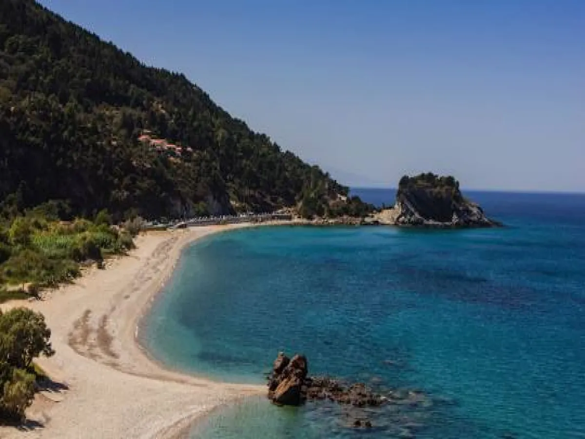
Potami is a small coastal settlement on the northwestern coast of Samos, a few kilometres west of Karlovasi. The area combines a long pebbled beach, the mouth of a stream, a densely vegetated gorge with successive waterfalls, a Byzantine church and a small fortified complex.
Unlike a traditional settlement with a compact historic centre, Potami is sparsely developed around the beach, the coastal road and the entrance to the gorge. The few houses, seasonal businesses, beach and natural attractions create a place that becomes particularly lively during the summer months.
According to the 2021 census, Potami has 12 permanent residents. Administratively, it belongs to the Municipal Community of Karlovasi, the Municipal Unit of Karlovasi and the Municipality of Western Samos. The municipality forms part of the Regional Unit of Samos in the North Aegean Region.
📍 Location and Character
Potami lies on the northwestern side of Samos, west of Karlovasi Port. It is situated almost at sea level, at an altitude of approximately 5 metres, between the coastline and the steep, densely vegetated inland slopes.
The main natural feature of the area is the stream that descends through the narrow gorge and flows into the sea. Dense riverside vegetation grows around it, including plane trees, reeds, shrubs and other trees, creating a striking contrast with the rocky northern coastline.
The proximity of the beach, gorge, waterfalls and Byzantine monument complex makes Potami one of the areas of Samos where nature and history can be experienced within a very short distance.
📝 The Name Potami
The name comes from the stream that flows through the gorge and reaches the northern coast. Although it is not a large river, the presence of permanent or seasonal water flow, natural pools and waterfalls led to the establishment of the place name Potami, meaning “river” in Greek.
The name is now used for the official settlement, the beach, the gorge, the waterfalls and the wider natural area west of Karlovasi.
🏛️ Administrative Development
Potami was officially recognised as a separate settlement on 5 April 1981 and incorporated into the former Municipality of Karlovasi.
Under the Kallikratis administrative reform of 2010, it became part of the unified Municipality of Samos. Since 2019, it has belonged to the Municipality of Western Samos.
The present Municipal Community of Karlovasi includes Neo Karlovasi, the Monastery of Profitis Ilias, Potami, Sakkouleika and Sourides.
👥 Population and Seasonal Life
The 2011 census recorded 29 permanent residents, while the 2021 census recorded 12. The small population is connected with the limited number of permanent homes and the strongly seasonal character of the coastal zone.
During summer, the atmosphere changes noticeably. The beach attracts residents of Karlovasi and visitors, dining and leisure businesses operate more regularly and the area becomes a starting point for the waterfalls and hiking routes.
In winter, Potami is considerably quieter, with limited tourism activity. The gorge, however, often carries more water and its natural scenery can become particularly impressive.
🏘️ The Settlement Today
Potami does not have a central square, densely built historic centre or organised commercial district. Houses and other buildings are sparsely distributed along the road and around the beach.
Seasonal dining and leisure businesses operate in the coastal area, while a few homes and auxiliary buildings are found in the wider surroundings. The limited scale of development allows the natural landscape to remain the dominant feature.
Potami is not an abandoned historic settlement. It is a small, officially recognised coastal settlement with a very limited permanent population and increased seasonal activity.
🏖️ Potami Beach
Potami Beach is one of the best-known stretches of coastline in western and northern Samos. It extends for approximately 700–750 metres and is covered mainly with white and grey pebbles.
The water is clean, cool and becomes relatively deep quite quickly. The beach faces the northern Aegean and is not fully protected from the wind. When strong northerly or northwesterly winds prevail, substantial waves may develop.
There are organised sections with umbrellas and sunbeds near the seasonal businesses, as well as extensive free areas where visitors can use their own beach equipment.
🌊 Swimming and Sea Conditions
Potami is suitable for swimming when the sea is calm. The seabed is mainly pebbled and the depth increases quickly in several places, so families with young children and less confident swimmers should exercise caution.
Water shoes are useful because of the pebbles, while checking the wind forecast before visiting is advisable.
The hours around sunset are particularly attractive, as the position of the beach offers open views towards the west and the northern Aegean.
💧 The Stream Mouth and Coastal Wetland
The stream reaches the beach and forms a small natural estuary. The site has been included in the network of Greek island wetlands under the name “Potami Estuary of Karlovasi”, with the identification code GR412SAM009.
The amount of water varies according to the season and rainfall. Flow is generally stronger during winter and spring, while it may be limited during a dry summer.
The estuary and its riverside vegetation form a sensitive natural environment. The area should not be used for parking, waste disposal or uncontrolled vehicle access.
🌿 Landscape of Outstanding Natural Beauty
The Potami area of Samos has been recorded as a Landscape of Outstanding Natural Beauty, with the code AT5011055. The designation refers to the river landscape and the narrow gorge where successive waterfalls and small natural pools are formed.
The natural environment includes flowing water, steep rocky sides, dense vegetation and shaded passages. The presence of water creates a microclimate that is noticeably cooler than the beach, particularly inside the gorge.
The area has significant scenic, natural and ecotourism value, but it is vulnerable to pollution, rubbish and excessive water extraction.
🥾 The Route to the Waterfalls
The route to the waterfalls begins behind the beach and passes close to the Byzantine church. The first section follows the stream through dense vegetation, with wooden footbridges, shaded passages and points beside the water.
The distance to the first principal areas of the gorge is approximately one kilometre. Beyond this point, the route becomes more demanding, as it continues through the streambed and between natural pools and rocks.
Three distinctive waterfalls and several small pools are formed in the area. The amount and force of the water vary according to the season, rainfall and weather conditions.
⚠️ Safety Along the Waterfall Route
The route to the initial section of the gorge is relatively easy for visitors wearing suitable footwear. Continuing towards the higher sections, however, is not a simple walk.
At several points, visitors must move through water, swim across natural pools or cross wet and slippery rocks. The complete ascent of the waterfalls is considered fairly difficult.
Entry into the gorge is not recommended:
✅ After heavy rainfall
✅ When the water is fast-flowing or cloudy
✅ With unsuitable footwear
✅ Without the ability to swim safely
✅ Very late in the afternoon
✅ When bridges or supporting passages are damaged
Children must be continuously supervised. Water shoes or closed, non-slip footwear suitable for getting wet are particularly useful.
⛪ The Church of the Transfiguration of the Saviour
Near the entrance to the gorge stands the Church of the Dormition of the Virgin Mary, now better known as the Transfiguration of the Saviour, Panagia tou Potamou or Agia Sotiro.
It is the most important and best-preserved Byzantine monument on Samos. Its earliest construction phase dates to the 11th century, while its present form developed through alterations and interventions completed by the 14th century.
The church belongs to the architectural type of a simple four-column cross-in-square church. Four marble columns support the dome, while its masonry and architectural design reveal influences from the art of Constantinople.
🙏 The Religious Tradition of Agia Sotiro
The church celebrates on 6 August, the Feast of the Transfiguration of the Saviour. In the past, it was more widely known as Panagia tou Potamou and was also connected with the celebration of the Dormition of the Virgin Mary.
On the eve of the feast, the tradition of preparing the giorti is maintained. This is a communal dish cooked for many hours in a large cauldron and distributed to worshippers after the service.
Before the present road was opened, residents of Karlovasi reached the area either by boat or by following the old path from Palaio Karlovasi. Construction of the road towards Potami began in the late 1960s.
🏰 The Byzantine Castle
On a rocky projection above the church stands a small fortified complex known as the Castle of Potami or Kastraki of Panagia.
Although it is often described as “Genoese” or “Venetian”, the Greek Ministry of Culture identifies it as a Byzantine castle, forming part of the same monument complex as the Church of the Transfiguration and the Church of Agios Nikolaos.
The castle is small and is protected by the natural shape of the rock. A substantial wall, battlements and the entrance gate survive on its northeastern side.
Inside are the foundations of a small triconch church dedicated to the Holy Trinity, along with a vaulted structure that was probably used as a water cistern.
⛪ The Ruined Church of Agios Nikolaos
Approximately 150 metres north of the Church of the Transfiguration are the remains of a small church dedicated to Agios Nikolaos.
The church survives in a ruined condition and forms part of the wider archaeological site. Its presence strengthens the interpretation of the area as an organised religious and defensive complex that developed during the Byzantine and medieval periods.
It should not be confused with the later chapel of Agios Nikolaos, which stands on a hill near the beach and is a distinctive landmark along the coastline.
🧱 Restoration of the Monument Complex
The conservation, structural stabilisation and restoration of the Church of the Transfiguration, the Byzantine castle and the small Church of Agios Nikolaos were completed in 2024.
The project included strengthening and restoring the monuments, arranging the interior of the castle, improving access along the stream and enhancing the surrounding area.
The formal reopening of the restored church took place on 6 August 2025.
🧗 The Potami Climbing Area
The wider area includes the Potami climbing field, with sport-climbing routes on natural rock. It is one of the recorded climbing areas of Samos.
Use of the routes requires experience, suitable equipment and knowledge of climbing protection techniques. Before attempting any route, the present condition of the bolts and rock should be checked by an experienced climber or a local association.
The site should not be treated as a supervised tourism facility with equipment or instruction provided.
🌲 The Surrounding Area and Hiking Routes
West of Potami begins the wilder and more isolated coastline of northwestern Samos. Hiking routes start from the area towards Mikro Seitani and, farther away, Megalo Seitani.
The trails cross slopes, rocky areas and sections with limited shade. Suitable footwear, sufficient water, sun protection and an early start are required.
To the east lies Karlovasi Port, followed by the different historic districts of Karlovasi, with their former tanneries, neoclassical buildings and large churches.
🍽️ Food and Facilities
During summer, dining and leisure establishments operate along the beach, offering coffee, drinks, snacks and meals. Umbrellas and sunbeds are available in certain sections.
The businesses operate mainly on a seasonal basis, and their opening hours and periods may vary. Visitors should not assume that a business will be open during winter.
There are places near the beach where a limited number of vehicles can park. During busy periods, care is required not to obstruct the road, the entrance to the gorge or the stream mouth.
🌿 What to See
During your visit to Potami, take time to discover:
✅ The long pebbled Potami Beach
✅ The mouth of the stream where it reaches the sea
✅ The densely vegetated gorge
✅ The successive waterfalls and natural pools
✅ The wooden footbridges along the first part of the route
✅ The Byzantine Church of the Transfiguration of the Saviour
✅ The surrounding archaeological site
✅ The Byzantine Castle of Potami
✅ The remains of the Church of Agios Nikolaos
✅ The later chapel of Agios Nikolaos above the coast
✅ The climbing area
✅ The sunset from the western side of the beach
✅ The beginning of the hiking routes towards Seitani
🚶 The Visitor Experience
A complete visit can begin at the beach and the mouth of the stream. The route then continues towards the Church of the Transfiguration and the first section of the gorge.
Visitors seeking an easier experience can limit their walk to the church, the beginning of the trail and the first footbridges. Reaching the waterfalls is considerably more demanding and requires movement through water.
Approximately two to three hours are needed for the beach, church and a short walk into the gorge. Swimming, exploring the waterfalls and dining can easily occupy most of the day.
📆 When to Visit
Spring: The best period for lush vegetation, stronger water flow and mild temperatures.
Summer: Suitable for swimming and for access to seasonal businesses. Morning is preferable for visiting the waterfalls.
6 August: The Feast of the Transfiguration of the Saviour, when more worshippers and visitors are present.
Late afternoon: Suitable for the beach, walking and sunset, but not for entering the gorge late in the day.
Autumn: A quieter period, suitable for exploring while the weather remains stable.
Winter: Water flow may be stronger, but entering the gorge after heavy rain can be dangerous.
🧭 How to Get There
Access is from Karlovasi by a paved coastal road beginning west of the port.
Potami lies approximately 3 kilometres from Karlovasi Port and around 5 kilometres from the centre of Neo Karlovasi. The drive is short and does not require a special vehicle.
Walking from the port is possible and takes approximately 40–50 minutes, depending on pace. Walking from the centre of Neo Karlovasi requires more time.
The settlement lies approximately 36 kilometres by road from Samos Town and 41 kilometres from Pythagoreio.
ℹ️ Useful Information
✅ Official name: Potami
✅ Character: Small coastal and seasonal settlement
✅ Location: Northwestern Samos, west of Karlovasi
✅ Administrative community: Municipal Community of Karlovasi
✅ Municipal unit: Karlovasi
✅ Municipality: Western Samos
✅ Regional unit: Samos
✅ Region: North Aegean
✅ First official recognition: 5 April 1981
✅ Population in 2021: 12 permanent residents
✅ Population in 2011: 29 permanent residents
✅ Altitude: Approximately 5 metres
✅ Main beach: Potami Beach
✅ Shore composition: Mainly pebbles
✅ Beach length: Approximately 700–750 metres
✅ Sea: Clean, cool and relatively deep
✅ Protection from wind: Limited—affected by northerly winds
✅ Beach organisation: Partial, with both free and organised sections
✅ Natural attraction: Gorge with three waterfalls and small natural pools
✅ Landscape designation: Landscape of Outstanding Natural Beauty
✅ Landscape code: AT5011055
✅ Recorded wetland: Potami Estuary of Karlovasi
✅ Wetland code: GR412SAM009
✅ Principal Byzantine monument: Church of the Transfiguration of the Saviour
✅ Original dating of the church: 11th century
✅ Feast day: 6 August
✅ Fortified monument: Byzantine Castle of Potami
✅ Second historic church: Ruined Church of Agios Nikolaos
✅ Completion of restoration works: 2024
✅ Formal reopening of the restored church: 6 August 2025
✅ Alternative activity: Sport climbing
✅ Distance from Karlovasi Port: Approximately 3 kilometres
✅ Distance from Neo Karlovasi: Approximately 5 kilometres
✅ Distance from Samos Town: Approximately 36 kilometres
✅ Distance from Pythagoreio: Approximately 41 kilometres
✅ Postal code: 83200
✅ GPS coordinates: 37.7897, 26.6663
✅ Road access: Paved road
✅ Access to the first waterfalls: On foot through the gorge
✅ Difficulty of the complete route: Moderate to difficult
✅ Suggested visiting time: Approximately 2 hours to a full day
✅ Ideal for: Swimming, nature, Byzantine history, photography, hiking, waterfalls and climbing




Add new comment