
Roman Aqueduct of Samos – Agiades & Pythagoreio
💧 The great water-supply project of Roman Samos
In the countryside north and west of Pythagoreio, remains survive of a second major water-supply system of ancient Samos: the Roman Aqueduct.
Centuries after the construction of the famous Tunnel of Eupalinos water system, the Romans created a new network to carry water to the city. Unlike the Eupalinean system, much of which was underground, the Roman aqueduct included above-ground masonry sections and arched structures adapted to the terrain.
Its surviving remains form a lesser-known but particularly interesting part of the ancient engineering heritage of Samos.
📍 Location & route
The Roman Aqueduct is not a single monument located at one point. It was a linear structure extending for several kilometres, of which only fragmented sections survive today in different locations.
The system carried drinking water from the inland area towards the ancient city of Samos, present-day Pythagoreio. The area of Myloi is associated with the aqueduct’s water supply, while the Zastano spring, north of Myloi, has also been considered a possible source.
The complete original route has not been reconstructed with absolute certainty, as large sections have been destroyed or covered by later interventions and natural deposits.
🏛️ A different system from the Eupalinean Aqueduct
The Roman Aqueduct should be clearly distinguished from the Eupalinean Aqueduct.
The work of Eupalinos was constructed in the 6th century BC and carried water from the Agiades spring towards the ancient city through a system more than 2.5 kilometres long, centred on the famous 1,036-metre tunnel beneath Mount Kastro.
The Roman Aqueduct was created many centuries later as a separate water-supply system, at a time when the city had different and increased water requirements.
🏗️ Above-ground channels & arches
One of the features that distinguishes the Roman system from the Eupalinean one is the use of masonry channels above ground and arched supports.
Where the terrain allowed water to flow smoothly, the channel could follow the natural slope of the hillside. Across depressions and small ravines, however, supporting structures were required to maintain the necessary elevation for continuous flow.
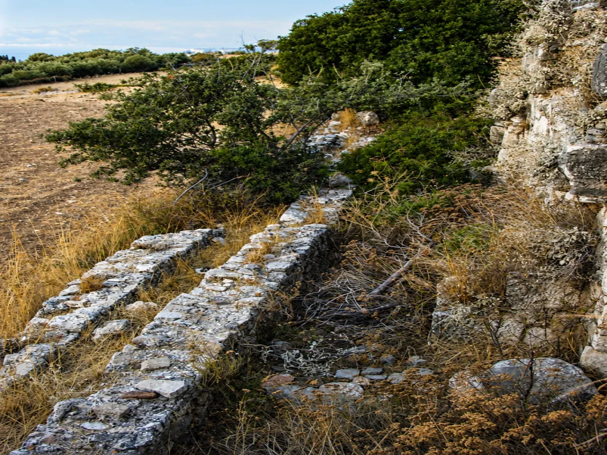
Sections of the aqueduct infrastructure still survive southwest of Mount Kastro, west of Pythagoreio, together with masonry channels and other traces along its former route.
💦 The force of gravity
Like most ancient aqueducts, the system relied on gravity flow.
The water had to begin at a higher elevation and follow a carefully controlled descent towards the city. A slope that was too steep could cause excessive speed and damage to the channel, while insufficient or reversed gradient would stop the flow.
Designing a structure stretching for several kilometres across hills, slopes and depressions therefore required detailed knowledge of the terrain and careful engineering.
🛁 The need for more water in the Roman city
During the Roman period, the ancient city contained major public facilities, including the Roman Baths, which required a stable and substantial supply of water.
The water system therefore had to serve not only the everyday needs of residents but also bathing complexes and other urban infrastructure.
The new aqueduct consequently became an important element in the operation and development of the Roman city.
⏳ When exactly was it built?
The aqueduct belongs to the Roman period, but the precise date of its original construction has not been established with certainty.
There is insufficient evidence to attribute it securely to a particular emperor or a specific century.
It is therefore preferable to regard it as an engineering work of the Roman era that may have undergone different phases of use and maintenance.
🧱 What survives today
Most of the aqueduct does not survive as a continuous structure.
Its route crossed a large area, and many sections have been destroyed, buried or incorporated into the modern agricultural landscape.
At several locations, however, masonry substructures, sections of channels and arched constructions remain visible, offering an impression of the aqueduct’s form and engineering.
Interesting remains also survive in the wider Agiades area, close to the ancient quarries and the northern side of Mount Kastro.
🥾 Access & visiting
The Roman Aqueduct is not an organised archaeological site with a single central entrance.
Its surviving sections are located in rural and semi-mountainous areas, and access to some of them is via dirt roads or footpaths.
Visitors should keep in mind that the remains are fragmented and often integrated into the natural landscape, so care is required when approaching them.
The reference point is located near Agiades, at a place where visible remains of the aqueduct survive.
👀 What visitors will see
The Roman Aqueduct of Samos does not survive as a single complete monument.
The experience is based on observing masonry channels, structural remains, arched sections and traces of the original route within the natural and agricultural landscape.
The remains reveal how Roman engineers used the natural slope of the terrain to create an extensive system for carrying water towards the ancient city.
Together with the earlier Eupalinean Aqueduct, they form important evidence of the long tradition of hydraulic engineering on Samos.


Add new comment