
Lazaros Castle – The Ancient Refuge of the Samians on Mount Karvounis
🏰 Lazaros Castle on Mount Karvounis, Samos
High on Mount Ampelos, also known as Karvounis, above the wider Vourliotes area, lie the modest but historically significant remains of Lazaros Castle, a Byzantine fortified settlement established during one of the most turbulent periods in the history of the Aegean.
At an altitude of more than 1,000 metres, on an extensive mountain plateau offering natural protection and exceptional visibility over the surrounding landscape, inhabitants could retreat from the vulnerable coastal areas to a location that was extremely difficult for raiders to reach.
Lazaros Castle belongs to a group of mountain fortifications that developed in northern Samos during the transitional Byzantine period.
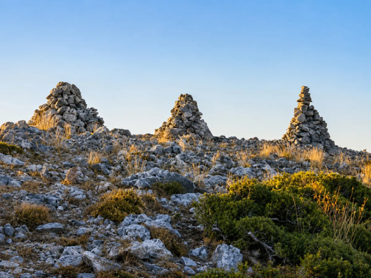
Today, the surviving remains mainly consist of sections of the defensive walls, the gate, foundations of small buildings, water cisterns and the ruins of a small Christian church, all set within a rugged mountain landscape where only faint traces remain of the much more intensive human presence of the past.
📍 Location
Lazaros Castle is situated on Lazaros Peak on Mount Ampelos – Karvounis, south of the wider Vourliotes area, in the northern-central part of Samos.
The site lies at an altitude of approximately 1,010–1,037 metres, with slight variations depending on the mapping source and the exact point of measurement.
From the summit there are extensive views towards both the northern and southern parts of the island, which helps explain the strategic choice of the location.
The castle lies within the mountainous landscape of Ampelos, a large part of which is protected as the Natura 2000 Special Area of Conservation GR4120002 “Samos: Mount Ampelos (Karvounis)”.
The protected landscape includes pine forests, Mediterranean scrub and important mountain habitats.
🕰️ A Fortified Settlement of the Transitional Byzantine Period
The foundation of Lazaros Castle is generally dated to the middle of the 7th century AD.
Research on the Christian monuments of the Aegean indicates that the fortified settlement was established by inhabitants of coastal areas of Samos who moved into the mountains in search of protection from Arab raids.
This dating also fits a broader archaeological picture. Research into the fortifications of northern Samos examines Lazaros Castle together with other defensive sites as part of a network that developed between the 7th and 9th centuries, during a period of major political and social transformation in the Aegean.
⚔️ Arab Raids & Changes in the Settlement Pattern
From the middle of the 7th century onward, military and political conditions in the Aegean changed dramatically.
Arab raids and the wider insecurity affecting maritime routes made many island coastal settlements increasingly vulnerable.
On Samos, part of the population appears to have sought safer locations further inland and in the mountains.
Lazaros Castle is a characteristic example of this development: settlement shifted to a high-altitude location surrounded by fortifications and protected at the same time by the natural terrain.
It is therefore unnecessary to repeat the older claim that there was “no organised Byzantine fleet” at the time. Byzantine naval organisation was considerably more complex.
What can be stated with much greater confidence is that increased insecurity caused by Arab raids contributed to population movements towards naturally protected inland positions.
🏘️ A Castle or a Fortified Settlement?
The word “castle” can easily create the impression of a compact military fortress with towers, battlements and a permanent garrison.
Lazaros Castle appears to have had a different character.
Its considerable size, together with the foundations of numerous small buildings, water cisterns and a church, suggests that it functioned more as a fortified settlement and refuge where a civilian population could live, rather than as a purely military fortress.
This is one of the most important aspects for understanding the site: the defensive walls did not protect only soldiers, but an entire inhabited area.
📐 A Large Fortified Plateau
The fortified area is recorded as measuring approximately 380 × 120 metres and occupies the relatively level plateau near the summit.
These dimensions are considerable for an isolated mountain refuge and further support the interpretation that the site was more than a small lookout post.
The natural topography of the summit formed an important part of the defensive system. Steep slopes limited the possible approaches, while the fortification walls supplemented the protection provided by the terrain.
🧱 The Defensive Walls
Only limited sections of the surrounding fortifications survive today.
Archaeological descriptions characterise parts of the wall as dry-stone construction, while other records note surviving sections of the enclosure and the entrance gate.
Because much of the fortification has collapsed or become visually absorbed into the rocky landscape, it is now difficult to appreciate immediately the original scale of the settlement.
🚪 The Gate
According to archaeological records, the main gateway was situated on the southern–southwestern side of the enclosure.
Parts of the entrance remain among the characteristic features of the fortification that can still be identified on the site.
The location of the gate is particularly useful for understanding the organisation of the settlement, as it indicates the direction from which controlled access to the protected plateau was possible.
🏠 Remains of the Houses
Inside the fortified enclosure are foundations and low wall remains belonging to numerous small buildings.
Their layout has led researchers to conclude that a significant part of the enclosed area was used for habitation.
Today, many of these traces can be difficult to distinguish among the stones and vegetation, but the overall pattern indicates that an organised community once occupied the summit.
🏘️ The “500 Houses” Mentioned by Kritkidis
One of the most interesting historical accounts concerning Lazaros Castle comes from the Samian scholar Emmanouil Kritkidis.
In his Topography of Samos of 1869, according to later references to his work, Kritkidis stated that the fortified settlement contained 500 houses.
This is valuable as a 19th-century historical testimony, but it should not be presented as a modern archaeological count.
The surviving remains confirm the existence of many buildings, but they do not independently establish an archaeologically verified total of 500 houses.
💧 The Water Cisterns
A particularly important feature within the castle is the presence of water cisterns.
Archaeological literature explicitly records cisterns together with the small buildings and church within the settlement.
For a community living at an altitude of more than one thousand metres, the ability to collect and store water was essential.
The presence of these cisterns indicates that the site was designed to support human occupation for meaningful periods of time rather than serving merely as a temporary military observation post.
⛪ The Small Church Inside the Castle
The fortified settlement also contains the ruins of a small single-aisled Christian church, described in archaeological literature as a small single-aisled basilica.
The presence of a church within the enclosure is further evidence that the site supported an organised resident population.
There is, however, no secure evidence that this church was actually dedicated to Saint Lazarus.
❓ Where Does the Name “Lazaros” Come From?
Traditional explanations connect the name of both the summit and the castle with the small church inside the enclosure, suggesting that it may have been dedicated to Saint Lazarus.
However, the relevant sources use cautious terms such as “probably” or “apparently”, meaning that the dedication has not been confirmed by an inscription or other definitive archaeological evidence.
It is therefore preferable to present this as a possible explanation for the name rather than as an established fact.
🛡️ A Network of Mountain Refuges
Lazaros Castle was not the only fortified position in the wider region.
Archaeological research into the fortifications of northern Samos examines Lazaros Castle, Loulouda Castle and the fortification of Profitis Ilias, together with other sites, as part of the defensive and settlement landscape of the 7th–9th centuries.
The resulting picture is that of a network of mountain positions capable of providing security, surveillance and habitation when coastal areas became dangerous.
Lazaros Castle therefore becomes more meaningful when understood not as an isolated ruin but as part of this broader transformation in the settlement geography of Samos.
🏛️ Connection with the Vourliotes Area
Lazaros Peak rises above the wider Vourliotes area, where other important Early Christian and Byzantine remains have also been recorded.
These monuments demonstrate that the northern slopes of Karvounis experienced significant human activity long before the creation of the present-day villages.
Lazaros Castle is therefore an important link in understanding the movement of people from lower and coastal zones towards better-protected mountain locations during the early Byzantine period.
📜 Was It Really Inhabited Until 1476?
Later local sources state that the last residents left Lazaros Castle in 1476, during a period of severe population decline on Samos when many inhabitants moved towards Chios and Asia Minor.
This account is based mainly on later historiographical traditions associated with Kritkidis.
However, the archaeological picture does not fully support a continuous occupation until the 15th century.
Later presentations of archaeological research note that clear evidence of Middle Byzantine occupation has not been identified within the castle, raising questions about whether the settlement remained continuously inhabited until 1476.
It is therefore safer not to present 1476 as a certain date for the final abandonment of the settlement.
🌄 The Strategic View
The choice of Lazaros Peak was clearly deliberate.
From its high altitude there are extensive views towards inland areas and maritime zones on both the northern and southern sides of Samos.
This provided an opportunity to observe movement over a wide area while keeping the settlement far removed from easily accessible sections of coastline.
The panoramic views that today form one of the most impressive aspects of the hiking experience once had an important practical and defensive function.
🌲 The Natural Landscape of Karvounis
The modern experience of the site is strongly shaped by the mountain environment of Karvounis.
Mount Ampelos reaches a maximum elevation of approximately 1,153 metres, while much of its higher terrain lies within the protected Natura 2000 area GR4120002.
The landscape is characterised by pine forests, Mediterranean scrub, rocky mountain terrain and significant biodiversity.
A visit to Lazaros Castle therefore combines Byzantine history with one of the most important mountain landscapes of Samos.
🏚️ What Survives Today
Lazaros Castle is now in a ruined state, and the original organisation of the settlement is no longer immediately easy to understand.
The surviving remains include:
✅ Sections of the perimeter wall
✅ Remains of the main gateway
✅ Foundations and low walls of small buildings
✅ Remains of residential structures
✅ Water cisterns
✅ Ruins of a small single-aisled basilica
✅ Scattered building material across the mountain plateau
Together, these remains confirm that the site was a genuine fortified settlement rather than merely an isolated defensive tower.
🥾 Access & Visiting
Lazaros Castle is not an organised archaeological site with a ticket office, security personnel or fixed visiting hours.
Available records describe the site as freely accessible and unfenced, with no entrance fee.
Its remote mountain location, however, means that a visit should not be treated like an ordinary stop at a conventional tourist attraction.
Visitors should preferably bring:
✅ Suitable hiking or sturdy walking shoes
✅ A map or offline GPS
✅ Sufficient drinking water
✅ Appropriate weather conditions
✅ Avoidance of days with extreme heat, thunderstorms or strong winds
✅ Extra caution near steep slopes and ruined structures
GPS navigation can be particularly useful at an isolated mountain monument without organised tourist infrastructure.
📷 A Different Kind of Photography Location
The photographic interest of Lazaros Castle does not come from large, well-preserved towers or monumental walls.
Its character comes from the relationship between the scattered ruins and the vast surrounding mountain landscape.
Particularly interesting subjects include:
✅ Surviving sections of the old fortification
✅ The area around the gate
✅ Foundations of buildings across the plateau
✅ Ruins of the small church
✅ Stone structures almost disappearing into the natural terrain
✅ Panoramic views from the summit towards different parts of Samos
🧭 Places to Combine with the Area
A visit can form part of a wider exploration of the northern slopes of Karvounis and the Vourliotes area.
Nearby and within the wider region are:
✅ Vourliotes
✅ Monastery of Vronta
✅ Pnaka
✅ Loulouda Castle
✅ Profitis Ilias Peak on Karvounis
Together, these locations help reveal the close relationship between settlements, monasteries, fortified sites and the mountainous terrain of northern Samos.
⭐ A Mountain Refuge from a Difficult Period
Lazaros Castle is important not because it preserves spectacular towers or high defensive walls, but because it reflects a profound change in the way people on Samos responded to insecurity in the Aegean during the 7th century.
Where today there are scattered stones, low foundations and fragments of walls, there once stood an organised mountain settlement with houses, water cisterns, a church and defensive fortifications.
The decision to establish a community at an altitude of more than one thousand metres shows just how dramatically historical conditions could reshape the settlement pattern of an island.
Perhaps this is the greatest value of Lazaros Castle today: it does not present an idealised image of a medieval fortress, but preserves rare evidence of the everyday need for shelter, water, faith and security during a particularly difficult period in the history of Samos.



Add new comment