
Vourliotes of Samos
🏞️ Vourliotes, Samos – The Historic Wine-growing Village on the Slopes of Karvounis
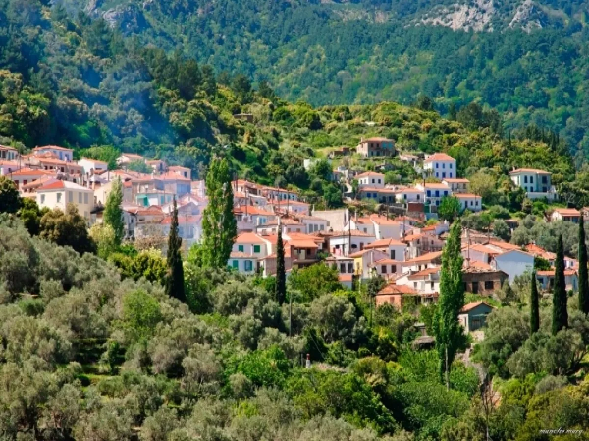
Vourliotes is one of the oldest and most characteristic mountain villages of Samos. It lies on the verdant northern slopes of Mount Ampelos, also known as Karvounis, within a landscape of pine forests, vineyards, olive groves, springs and panoramic views over the northern Aegean Sea.
The village retains a close connection with viticulture and the famous white Muscat grape of Samos. Houses with tiled roofs, narrow stone-paved passages, old fountains and the plane-tree-shaded square form a settlement that continues to preserve its traditional and welcoming character.
The history of Vourliotes is connected with settlers who arrived from Vourla in Ionia following the repopulation of Samos. Smaller settlements, agricultural installations and coastal locations later developed from the village and the surrounding area, shaping an important part of the social and economic life of northern Samos.
📍 Location and natural environment
Vourliotes is situated in the central part of northern Samos, on the northern slopes of Mount Ampelos–Karvounis. The settlement is built at an elevation of approximately 330 metres, above the coastal zone extending between Kokkari, Avlakia and Agios Konstantinos.
The natural environment is characterised by dense vegetation, pine forests, cypress trees, olive trees, chestnut trees, plane trees and extensive vineyards. The springs and streams of the area contributed to the development of cultivation and the permanent settlement of its inhabitants.
From the northern and higher parts of the village, the view opens towards the Aegean Sea, the northern coast of Samos and, when visibility is clear, the opposite coast of Asia Minor.
The Vourliotes area has been designated a landscape of outstanding natural beauty, together with other historic settlements and natural areas of Samos.
🏛️ Administrative identity of the community
The Municipal Community of Vourliotes belongs to the Municipal Unit of Vathy, within the Municipality of Eastern Samos, the Regional Unit of Samos and the North Aegean Region.
The community includes four officially registered settlements:
✅ Vourliotes
✅ Avlakia
✅ Kampos
✅ Vronta Monastery
The Community of Vourliotes was established on 21 September 1918, with the settlement of Vourliotai as its administrative centre. Avlakia was included in the community from the time of its establishment, Vronta Monastery was recognised as a settlement in 1920 and Kampos in 1961.
Following subsequent administrative reforms, the community became part of the Municipality of Vathy, later the unified Municipality of Samos and, since 2019, the Municipality of Eastern Samos.
📜 The creation and historical development of the village
Vourliotes was established during the late 16th or early 17th century, during the repopulation of Samos following the island’s long period of abandonment.
The first settlers came largely from Vourla in Asia Minor, a historic Greek town of Ionia near Smyrna. Their settlement on Samos took place under the special administrative conditions introduced to attract new inhabitants and support the reconstruction of the island.
According to local tradition, the first residents initially settled at a lower elevation in the Palaiokori area, above present-day Kampos Vourlioton. The need for greater protection from pirate raids appears to have gradually led them to move towards the higher and more secure location of the present village.
The first detailed description of the settlement was written by Joseph Georgirenes, Archbishop of Samos, who referred to Vourliotes in 1677 as a colony of people originating from Vourla.
📝 The name Vourliotes
The name of the village originates from Vourla in Ionia, the homeland of its first inhabitants.
The people who settled in this area of Samos became known as Vourliotes, and the name was gradually adopted for the entire settlement.
The officially registered administrative name of the settlement is “Vourliotai”, while the modern Greek form “Vourliotes” is used in everyday speech.
🏘️ The development of the village and the Six Neighbourhoods
During the 17th and 18th centuries, Vourliotes developed into an important residential and productive centre of northern Samos.
The inhabitants gradually expanded towards the cultivated areas of the plain and the northern coast. The growth of viticulture and the need to transport wine and other products to the sea contributed to the establishment of smaller settlements and agricultural installations.
This residential expansion is associated with the development of Agios Konstantinos, Valeontades, Manolates, Stavrinides, Nenedes—present-day Ampelos—and Margarites.
During the period of the Principality of Samos, these settlements formed the Municipality of the Six Neighbourhoods, which played a particular role in the administrative organisation of north-central Samos.
📖 Descriptions by early travellers
In 1677, Joseph Georgirenes recorded approximately one hundred houses and one church in Vourliotes. He also reported that a considerable number of the inhabitants worked in logging, as the forests of the area provided timber suitable for buildings and wooden ships.
In 1702, the French traveller and botanist Joseph Pitton de Tournefort visited the area. Because of bad weather, he remained for three days at Vronta Monastery, recording his visit and information about the monastery and its natural surroundings.
At the end of the 19th century, Epameinondas Stamatiadis recorded 388 houses and 1,476 residents in Vourliotes. These figures reflect the considerable development of the settlement and its importance in the economic and social life of Samos.
👥 Population and present-day life
According to the 2021 Population Census, the settlement of Vourliotes has 370 permanent residents.
The entire Municipal Community of Vourliotes has 456 permanent residents:
✅ Vourliotes: 370 residents
✅ Kampos: 72 residents
✅ Avlakia: 14 residents
✅ Vronta Monastery: No permanent residents were recorded
The population has declined significantly compared with the periods when the village was one of the island’s largest agricultural centres.
Despite this demographic decline, Vourliotes remains an active village with permanent residents, traditional cafés, dining establishments, agricultural activities and increased visitor numbers during the summer months.
🏘️ The form and architecture of the village
Vourliotes is built amphitheatrically across sloping terrain. The form of the settlement follows the natural gradients of the mountain, with dense construction, narrow passages and small neighbourhoods.
The historic centre includes stone-built and rendered houses, tiled roofs, wooden window frames, external staircases, small balconies and traditional covered verandas.
The houses stand close together and are connected by uphill alleys, stone-paved sections and passages that are not suitable for vehicle traffic.
The architectural character of the village is complemented by stone fountains, flower-filled courtyards, plane trees, cypress trees and small gardens between the houses.
🌳 The square and the residential centre
The central square is the main meeting point for residents and visitors.
The plane trees provide natural shade, while traditional cafés and dining establishments operate around the square. The stone fountain, old houses and narrow streets beginning from the square create one of the most characteristic views of the village.
From the centre, visitors can follow short routes towards the different neighbourhoods, churches and viewpoints overlooking the Aegean Sea.
⛪ Churches and religious tradition
The Church of Saint John the Theologian and the Church of the Dormition of the Virgin Mary are among the most prominent religious buildings in the settlement and are closely connected with the village’s religious and social life.
The Church of Saint John the Theologian dates from the 18th century and historically maintained ties with Vronta Monastery. The Church of the Dormition of the Virgin Mary also dates from the 18th century.
The wider area contains additional chapels, older places of worship and small monastic dependencies associated with the history of Vronta Monastery and the agricultural installations surrounding the village.
⛪ Panagia Vronta Monastery
Approximately two kilometres southeast of Vourliotes stands the historic Monastery of Panagia Vronta, also known as Vrontiani or Kokkariani.
The monastery was founded in 1566 by the monks Iakovos and Makarios and is considered the oldest organised monastery established on Samos during the island’s repopulation.
The name “Vronta” is probably connected with the thunder and storms that occur in the mountainous area. The monastery acquired considerable property, a library, ecclesiastical treasures and substantial spiritual influence.
The complex suffered serious damage during the wildfire of 1999, followed by extensive restoration work. Today, it is an important religious and historical destination within a particularly dense forest landscape.
💧 Pnaka and the springs of the area
On the descent from Vourliotes towards Kampos lies Pnaka, a small green location with a spring, plane trees and flowing water.
The spring produces clear, cool water and formerly contributed to the water supply of the wider area. The old path connecting Kampos with Vourliotes passes through Pnaka, and parts of its traditional stone paving remain visible.
Small chapels and old agricultural installations can be found in the area, while the dense vegetation creates a cool natural refuge, particularly during the summer months.
🍇 Viticulture and Samian wine
Viticulture is a central element of the history and identity of Vourliotes.
The northern slopes of Karvounis offer suitable soil, elevation, humidity and orientation for cultivating the white Muscat grape of Samos.
The vineyards are arranged across terraces that retain the soil on the steep slopes and allow cultivation at different elevations. Vineyard maintenance and the grape harvest traditionally required a large workforce and represented a collective activity for the entire village.
In earlier times, wine was transported towards Kampos and the northern coast, from where it could be shipped to other regions of the Aegean and the eastern Mediterranean.
🌿 Agriculture and local production
In addition to viticulture, the inhabitants worked in olive cultivation, vegetable and fruit growing, beekeeping, livestock farming and logging.
Olive trees, vineyards, chestnut trees and small family gardens remain characteristic features of the landscape.
The production of olive oil, wine, honey, herbs and small-scale agricultural products continues to form an important part of the economic and cultural identity of the area.
🌊 Kampos Vourlioton and Avlakia
Kampos lies below the village, between the lower slopes of Karvounis and the northern coast. The area developed as an agricultural settlement with vineyards, olive groves, gardens and old facilities for processing agricultural products.
Old chapels, agricultural sites, sections of traditional stone paths and ruins of fortified structures from different periods of northern Samos have been recorded in the wider Kampos area.
Avlakia is a small coastal settlement belonging to the community, situated along the main Samos–Karlovasi road. During the period of the Principality of Samos, customs and harbour facilities operated in the area to support the transportation of products.
Today, Avlakia has a beach, dining establishments and easy road access, forming the natural coastal counterpart of the mountain village.
🥾 Hiking routes and exploration
Vourliotes is a starting point or intermediate stop for several hiking and agricultural routes:
✅ Route towards Vronta Monastery
✅ Old footpath towards Pnaka and Kampos
✅ Route through forests and vineyards towards Manolates
✅ Ascent towards the higher slopes of Karvounis
✅ Agricultural tracks among the vineyards
✅ Routes towards old churches and chapels
✅ Access towards the historic locations of Loulouda and Lazaros
The routes pass through dense vegetation, vineyards, springs and locations with open views towards the sea.
Trail conditions may vary according to the season, vegetation growth and recent weather conditions. Longer routes require suitable footwear, drinking water and reliable knowledge of the itinerary.
🍽️ Gastronomy and local flavours
In Vourliotes, visitors can discover dishes connected with the agricultural tradition and the products of the Samian land.
Local cuisine includes:
✅ Homemade cooked dishes
✅ Goat and meat prepared with local recipes
✅ Chickpea fritters
✅ Stuffed vine leaves
✅ Local cheeses
✅ Olives and olive oil
✅ Seasonal vegetables
✅ Honey and traditional sweets
✅ Souma
✅ Sweet and dry wines produced from Muscat grapes
The square and the surrounding streets contain the main options for coffee and dining, particularly during the summer season.
🛏️ Facilities and everyday services
Vourliotes has traditional cafés, dining establishments and limited options for basic shopping and accommodation.
Most businesses are concentrated around the square and the more easily accessible parts of the village. Some operate mainly during the summer season or follow different opening hours depending on the time of year.
A wider selection of shops, services and accommodation is available in Kokkari, Agios Konstantinos, the town of Samos and Karlovasi.
Parking is limited within the village’s narrow streets. It is preferable to leave the car in an open area close to the entrance or the main roads and continue exploring on foot.
🌿 What to see
During your visit to Vourliotes, look for:
✅ The central square with its plane trees and stone fountain
✅ The narrow stone-paved alleys
✅ The old houses with tiled roofs and covered verandas
✅ The Church of Saint John the Theologian
✅ The Church of the Dormition of the Virgin Mary
✅ The viewpoints overlooking the northern Aegean Sea
✅ The vineyards on the slopes of Karvounis
✅ Panagia Vronta Monastery
✅ The spring and location of Pnaka
✅ The old footpath towards Kampos
✅ The agricultural settlement of Kampos Vourlioton
✅ The coastal settlement of Avlakia
✅ The hiking routes towards Manolates and the mountain
🚶 Visitor experience
A visit can begin at the entrance to the village and continue on foot towards the square, the churches and the older neighbourhoods.
A basic exploration of the settlement requires approximately one to two hours. With a stop for coffee or food, photographs and exploration of the smaller streets, the visit can last longer.
Vronta Monastery and Pnaka can be combined with a visit to the village, creating a complete half-day route.
Hiking towards Manolates, Kampos or the higher slopes of Karvounis requires separate planning and additional time.
📆 When to visit
Spring: The best season for flowering landscapes, springs, walks and hiking through the forest.
Summer: The liveliest season, with more dining options, increased visitor numbers and the possibility of combining the village with the northern beaches.
Late summer: The period when the vineyards and grape-harvesting activities become particularly interesting.
Autumn: A suitable season for photography, quiet exploration, forest routes and discovering local agricultural life.
Winter: The village retains an authentic and peaceful atmosphere, but services are more limited and mountain weather can be cold or rainy.
Morning: A suitable time for hiking and visiting Vronta Monastery.
Afternoon: The ideal time for walking through the alleys, dining in the square and enjoying views over the Aegean Sea.
🧭 How to get there
Access is provided from the main coastal road connecting the town of Samos with Kokkari, Agios Konstantinos and Karlovasi.
A paved uphill road begins in the Kampos Vourlioton area and leads towards the village. The route passes through vineyards and dense vegetation and includes several bends.
Vourliotes is approximately:
✅ 9 kilometres from Kokkari
✅ 20–21 kilometres from the town of Samos
✅ 20 kilometres from Karlovasi
✅ 32 kilometres from Pythagoreio
✅ 31 kilometres from Samos Airport
✅ 2 kilometres from Vronta Monastery
✅ 5.5 kilometres from Kampos Vourlioton
✅ 6 kilometres from Avlakia
The road is paved and suitable for a standard car, although care is required on bends, narrower sections and during periods of increased summer traffic.
ℹ️ Useful information
✅ Official community name: Municipal Community of Vourliotes
✅ Official name of the main settlement: Vourliotai
✅ Common name: Vourliotes
✅ Character: Traditional mountain wine-growing village
✅ Location: Central northern Samos
✅ Municipal Unit: Vathy
✅ Municipality: Eastern Samos
✅ Regional Unit: Samos
✅ Region: North Aegean
✅ Community established: 21 September 1918
✅ Official settlements in the community: Four
✅ Settlements: Vourliotes, Avlakia, Kampos and Vronta Monastery
✅ Population of Vourliotes in 2021: 370 permanent residents
✅ Total community population in 2021: 456 permanent residents
✅ Elevation: Approximately 330 metres
✅ Period of establishment: Late 16th–early 17th century
✅ Origin of the name: From Vourla in Ionia
✅ Main traditional activity: Viticulture
✅ Main grape variety: White Muscat of Samos
✅ Main religious monument: Panagia Vronta Monastery
✅ Main natural location: Pnaka Spring
✅ Area designation: Landscape of outstanding natural beauty
✅ GPS coordinates of the centre: 37.78258, 26.84588
✅ Road access: Paved mountain road
✅ Recommended visiting time: From 1–2 hours to half a day
✅ Suitable for: Traditional village exploration, photography, gastronomy, viticulture, religious tourism, hiking and nature excursions



Add new comment