
Mesogeio Samos
🍇 Mesogeio, Samos – The Historic Mountain Village of Kato Arvanites
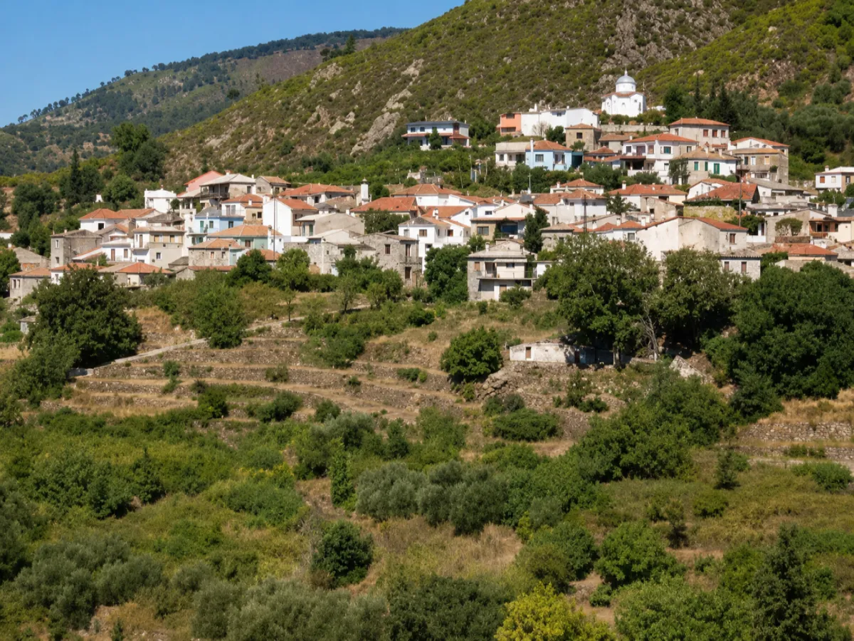
Mesogeio is one of the oldest mountain villages of Samos, built at an altitude of approximately 570 metres on the southwestern slopes of Mount Ampelos, also known as Karvounis. Vineyards, olive groves, pine forests and cultivated hillsides create a peaceful mountain landscape in the island’s interior.
Formerly known as Kato Arvanites, the village is historically connected with neighbouring Pandroso. Its traditional agricultural life, the parish Church of the Life-Giving Spring, the Folklore Museum and the routes towards Mount Karvounis are among its main points of interest.
According to the 2021 census, Mesogeio has 112 permanent residents. Administratively, it forms the Municipal Community of Mesogeio, which belongs to the Municipal Unit of Pythagoreio and the Municipality of Eastern Samos. The municipality is part of the Regional Unit of Samos in the North Aegean Region.
📍 Location and Mountain Landscape
Mesogeio lies in the central part of Samos, on the southwestern slopes of Mount Karvounis. At an altitude of approximately 570 metres, it is among the highest villages on the island.
Its setting faces the mountain slopes, forests and cultivated areas of the interior. Instead of open sea views, the landscape is dominated by mountains, valleys, olive groves and vineyards, offering a very different experience from the coastal settlements of Samos.
📝 The Former Name Kato Arvanites
The village’s former official name was Kato Arvanites, meaning Lower Arvanites, distinguishing it from Ano Arvanites, the present-day village of Pandroso.
In 1960, the settlement was officially renamed Mesogeion, while the Community of Kato Arvanites became the Community of Mesogeio. The current name is probably connected with the village’s inland position near the centre of Samos. The former name is still used by several residents of the island.
📜 The First Settlers
The history of Mesogeio is closely connected with that of Pandroso. Both villages were already mentioned in a description of Samos published in 1677, while their foundation is associated with the period during which the island was resettled after the middle of the 16th century.
The precise origin of the first inhabitants has not been conclusively documented. One tradition refers to families of Arvanite origin or families bearing the surname Arvanitis, while other historical interpretations connect the settlers with southern Epirus, Attica or Tinos. Ottoman registers from 1622 and 1642 record a settlement in the area known as the “village of Gikas”.
🏘️ The Creation of the Lower Village
Ano Arvanites appears to have formed the original centre of settlement, while the lower village was established later at a lower altitude.
In the census of 1828, Kato Arvanites was recorded with 41 houses and 95 residents. During the period of the Principality of Samos, from 1834 to 1912, Mesogeio and Pandroso formed the Municipality of Arvanites, with its administrative seat in Ano Arvanites.
🏛️ Administrative Development
The Community of Kato Arvanites was initially established in 1918. It was abolished in 1924, when the settlement was incorporated into the Community of Ano Arvanites, before being re-established as an independent community in 1928.
In 1960, it was renamed the Community of Mesogeio. Under the Kapodistrias administrative reform of 1997, it became part of the Municipality of Pythagoreio. In 2010, it was incorporated into the unified Municipality of Samos and, since 2019, has belonged to the Municipality of Eastern Samos.
👥 Population and Present-Day Life
Mesogeio had 386 residents in 1940, 310 in 1961, 262 in 1981, 209 in 1991, 143 in 2001 and 109 in 2011. The 2021 census recorded 112 permanent residents.
The population decline is associated with migration abroad and towards major urban centres, particularly from the beginning of the 20th century and after the Second World War. Despite these demographic changes, the village retains an active community, agricultural activity and local cultural traditions.
🏡 The Form of the Village
Mesogeio is a compact mountain settlement, with houses grouped around the main road, the village square and the parish church.
Along its lanes stand older houses with tiled roofs, stone foundations, courtyards and simple architectural features typical of the Samian countryside. The village’s modest size makes it easy to explore on foot while observing its neighbourhoods and the surrounding mountain landscape.
⛪ The Church of the Life-Giving Spring
The village’s parish church is dedicated to the Life-Giving Spring, known in Greek as Zoodochos Pigi, and its foundation stone was laid on 16 May 1839.
The church celebrates its feast on Bright Friday, the first Friday after Easter. The celebration is one of the village’s most important religious occasions and includes church services attended by residents and pilgrims.
🏺 The Folklore Museum of Mesogeio
At the entrance to the village stands the Folklore Museum of Mesogeio, housed in the former cooperative building and operated by the Cultural and Improvement Association “I Zoodochos Pigi”.
Its collections were created through donations from residents and include old photographs, traditional furniture, household utensils, documents, agricultural tools, a loom, a plough and a grape press. Most of the objects date from the late 19th century to the 1960s and present the village’s domestic, agricultural and family life.
The museum mainly operates during the summer season, while visits and guided tours can also be arranged in advance.
🍇 Viticulture and Olive Cultivation
The economy of Mesogeio was traditionally based on agriculture and livestock farming. Its most important crops are vines and olive trees, which benefit from the mountain terrain and the climate of the Karvounis slopes.
Viticulture is connected with the production of Samian wine and with traditional activities such as the grape harvest, grape pressing and the preparation of must, grape molasses and moustalevria, a traditional grape-must pudding. Tools associated with these activities are preserved in the village’s Folklore Museum.
🎉 The Moustalevria Festival
The Cultural and Improvement Association of Mesogeio “I Zoodochos Pigi” has organised the Moustalevria Festival in the village square, celebrating the grape harvest and the traditional use of grape must.
The event includes servings of moustalevria and local dishes, live music and traditional dancing. Its date and organisation are announced separately each year.
🌲 Forests, Vineyards and Mountain Nature
The area surrounding Mesogeio is characterised by pine forests, vineyards, olive groves and low mountain vegetation. In spring, the landscape becomes particularly green, while autumn agricultural work and the grape harvest give the slopes a different character.
The village’s geographical position and high altitude provide lower temperatures than the coastal areas, particularly during summer evenings.
🥾 The Route to Pandroso
Pandroso lies approximately 800 metres north of Mesogeio, making it easy to combine both villages in the same excursion.
Mountain and unpaved routes continue from Pandroso towards the higher slopes and ridge of Mount Karvounis. The area is suitable for hiking and exploring the island’s interior, although the condition of the unpaved roads varies according to the season and weather conditions.
🌿 What to See
During your visit to Mesogeio, take time to discover:
✅ The parish Church of the Life-Giving Spring
✅ The Folklore Museum of Mesogeio
✅ The village square and old neighbourhoods
✅ The traditional houses and courtyards
✅ The vineyards and olive groves
✅ The agricultural tools and old grape press in the museum
✅ The route towards neighbouring Pandroso
✅ The mountain routes towards Mount Karvounis
✅ The Moustalevria Festival, when organised
✅ The feast of the Life-Giving Spring after Easter
🚶 The Visitor Experience
A visit can begin at the Folklore Museum near the entrance to the village and continue towards the square, the Church of the Life-Giving Spring and the older neighbourhoods.
Visitors can then walk towards the vineyards or continue to Pandroso. Approximately 45–60 minutes are sufficient for a basic walk through Mesogeio, while a visit to the museum and an excursion to Pandroso can extend the experience to two or three hours.
📆 When to Visit
Spring: Suitable for green landscapes, flowering vegetation, mild temperatures and the feast of the Life-Giving Spring.
Summer: The altitude provides a cooler atmosphere, particularly during the afternoon and evening.
Grape-harvest season: Ideal for discovering the village’s winemaking tradition and the activities connected with harvesting grapes.
Autumn: Suitable for peaceful exploration, photography and contact with rural life.
Winter: The village is particularly quiet, although lower temperatures and weather conditions require careful driving.
🧭 How to Get There
Mesogeio is reached by a paved uphill road with several bends. The route is suitable for a conventional car and passes through the agricultural and mountain landscapes of central Samos.
The village lies approximately 19 kilometres from Pythagoreio, 32 kilometres from Samos Town, 22 kilometres from Karlovasi and 19 kilometres from Marathokampos.
ℹ️ Useful Information
✅ Official name: Mesogeion
✅ Contemporary name: Mesogeio
✅ Former name: Kato Arvanites
✅ Character: Historic mountain and agricultural settlement
✅ Location: Central Samos, southwestern slopes of Mount Karvounis
✅ Administrative community: Municipal Community of Mesogeio
✅ Municipal unit: Pythagoreio
✅ Municipality: Eastern Samos
✅ Regional unit: Samos
✅ Region: North Aegean
✅ Official renaming: 19 February 1960
✅ Population in 2021: 112 permanent residents
✅ Population in 2011: 109 permanent residents
✅ Altitude: Approximately 570 metres
✅ Main crops: Grapevines and olive trees
✅ Parish church: Church of the Life-Giving Spring
✅ Foundation of the church: 16 May 1839
✅ Religious celebration: Bright Friday
✅ Museum: Folklore Museum of Mesogeio
✅ Cultural association: “I Zoodochos Pigi”
✅ Traditional event: Moustalevria Festival
✅ Nearest village: Pandroso, approximately 800 metres away
✅ Distance from Pythagoreio: Approximately 19 kilometres
✅ Distance from Samos Town: Approximately 32 kilometres
✅ Distance from Karlovasi: Approximately 22 kilometres
✅ Distance from Marathokampos: Approximately 19 kilometres
✅ Postal code: 83104
✅ GPS coordinates: 37.7275, 26.8228
✅ Road access: Paved uphill road with bends
✅ Suggested visiting time: Approximately 1–3 hours
✅ Ideal for: History, folklore, rural landscapes, hiking and peaceful exploration



Add new comment