
Vigla – Summit of Mount Kerkis in Samos
⛰️ At the highest point of Samos
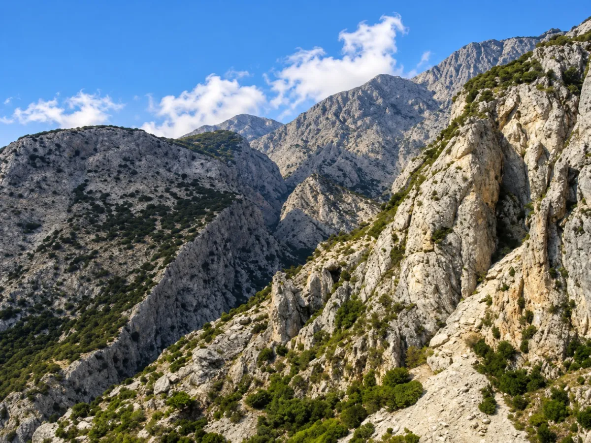
Vigla, at 1,443 metres, is the highest summit of Samos and dominates the mountain massif of Kerkis, also known as Kerketeas or Kerketeus, in the western part of the island.
The mountain stands out from a distance for its steep limestone slopes, deep ravines and bare rocky ridges.
The ascent to Vigla is one of the most demanding hiking experiences on Samos. The summit cannot be reached by road, and visiting it requires several hours of walking in genuine mountain terrain.
📍 Location
Vigla lies in the high central section of Mount Kerkis, in western Samos.
The mountain rises north of Marathokampos and Kampos Marathokampou and extends towards Kosmadaioi, Kallithea and the remote western and northwestern slopes of the island.
The summit is far from inhabited areas, and hikers must overcome a considerable elevation gain on foot to reach it.
🥾 The ascent to Vigla
There is more than one hiking route leading towards the summit.
One of the most common approaches is from the southern and eastern side of Mount Kerkis. The route climbs towards the higher slopes and passes through the area of Profitis Ilias, at an elevation of around 1,150 metres, before continuing towards Vigla.
At higher elevations the landscape becomes bare and strongly rocky. The trail often no longer resembles a clear dirt path but follows rocks, loose stones and route markers across the slope.
The ascent requires good physical condition, hiking experience and proper preparation.
🧭 Route 10 & Profitis Ilias
One of the well-known marked routes on Mount Kerkis is Route 10, which begins in the Mnimeio area and climbs towards Profitis Ilias and Vigla.
The route can then continue towards the Zastano summit and the Kakoperato area, forming a long mountain circuit.
The complete circular route is approximately 14 kilometres, with a total elevation gain exceeding 1,000 metres, making it a demanding full-day hike.
Hikers interested only in Vigla can follow the section leading to the summit and return by the same route.
⚠️ The difficult route from Panagia Makrini
Vigla can also be approached from the area of Panagia Makrini, but this route is considerably more demanding and exposed.
Part of the route follows a narrow rocky ridge, with very steep slopes and a significant drop on one side.
This approach is not suitable for beginners, people with a fear of heights or days with strong winds.
The route from this side should be treated as a mountaineering route requiring experience, appropriate equipment and careful assessment of weather conditions.
🪨 The rocky landscape of Mount Kerkis
At higher elevations, Mount Kerkis takes on a completely different appearance from the pine forests and Mediterranean scrub found lower down.
Open rocky terrain, limestone outcrops and steep slopes dominate the landscape, with low and sparse vegetation.
The dramatic gradients, ravines and numerous natural cavities are characteristic features of the massif and explain the rugged appearance of Kerkis from almost every direction.
🌲 From forest to bare summit
The changing landscape during the ascent is one of the most interesting aspects of the route.
At lower elevations, hikers encounter pine trees, cypresses and Mediterranean scrub, while higher up the trees become less frequent and the ground increasingly rocky.
Near the summit, vegetation is low and sparse, leaving almost the entire horizon open.
This transition gives hikers the feeling that within a few hours they have moved from Mediterranean woodland into a stark mountain landscape.
🦅 Protected natural environment
Mount Kerkis is one of the most important natural areas of Samos, and much of it is protected under the European Natura 2000 network.
The wider zone is included in Special Area of Conservation GR4120003, covering Kerkis, Seitani and the northwestern coasts, as well as in Special Protection Area GR4120008 – “Samos: Mount Kerkis”.
The area is particularly important for birds of prey and other species that use the rocky slopes, scrubland and forest zones of the mountain.
Avoiding fire, taking all litter away and remaining on existing routes are especially important.
🌊 Views from 1,443 metres
When the atmosphere is clear, Vigla offers exceptionally wide views across different parts of the Aegean.
From the summit, views open towards the western and southern coasts of Samos, Ikaria and Fournoi, as well as across large parts of the island itself.
To the east, the horizon extends towards the coast of Asia Minor, while the rugged shape of Mount Kerkis becomes particularly impressive when seen from above.
Conditions can change rapidly when clouds or mist appear, which is not unusual at such an exposed location.
🌬️ Wind & weather conditions
The summit is fully exposed to the wind, and conditions can differ significantly from those along the coast.
Even on a hot day at lower elevations, the ridge can experience strong winds, lower temperatures or reduced visibility.
The ascent should not be attempted when strong winds, thunderstorms or dense cloud are forecast.
An early start is important so that there is enough time for both the climb and the safe return before sunset.
☀️ The best time for the ascent
Spring and autumn usually offer the most suitable conditions for hiking on Mount Kerkis.
In summer, the bare rocky summit zone provides little or no shade, and exposure to the sun can become intense.
Anyone attempting the ascent during the warmer months should start very early in the morning and carry an adequate supply of water.
Winter requires even greater caution because of lower temperatures, strong winds and rapid changes in the weather.
🎒 What hikers should carry
The ascent to Vigla requires good hiking or mountaineering footwear, sufficient water, sun protection and suitable clothing for changes in temperature and wind.
An offline GPS track or reliable hiking map is particularly useful, as the continuation of the route may not always be obvious in rocky sections.
Hikers should not rely solely on mobile phone reception.
For those without experience on similar mountain routes, hiking with an experienced companion is the safer option.
👀 What visitors will experience
Vigla is not a sightseeing stop reached after a short walk.
The ascent itself is the attraction: the changing vegetation, steep limestone slopes, major elevation differences and gradual opening of views across the Aegean create one of the most complete mountain experiences on Samos.
At the summit, the bare rocky landscape and open horizon reward the hiker who reaches 1,443 metres, the highest natural point of the island.



Add new comment