
Megalo Seitani Beach | The Untouched Paradise of Samos
🏖️ Megalo Seitani Beach, Samos
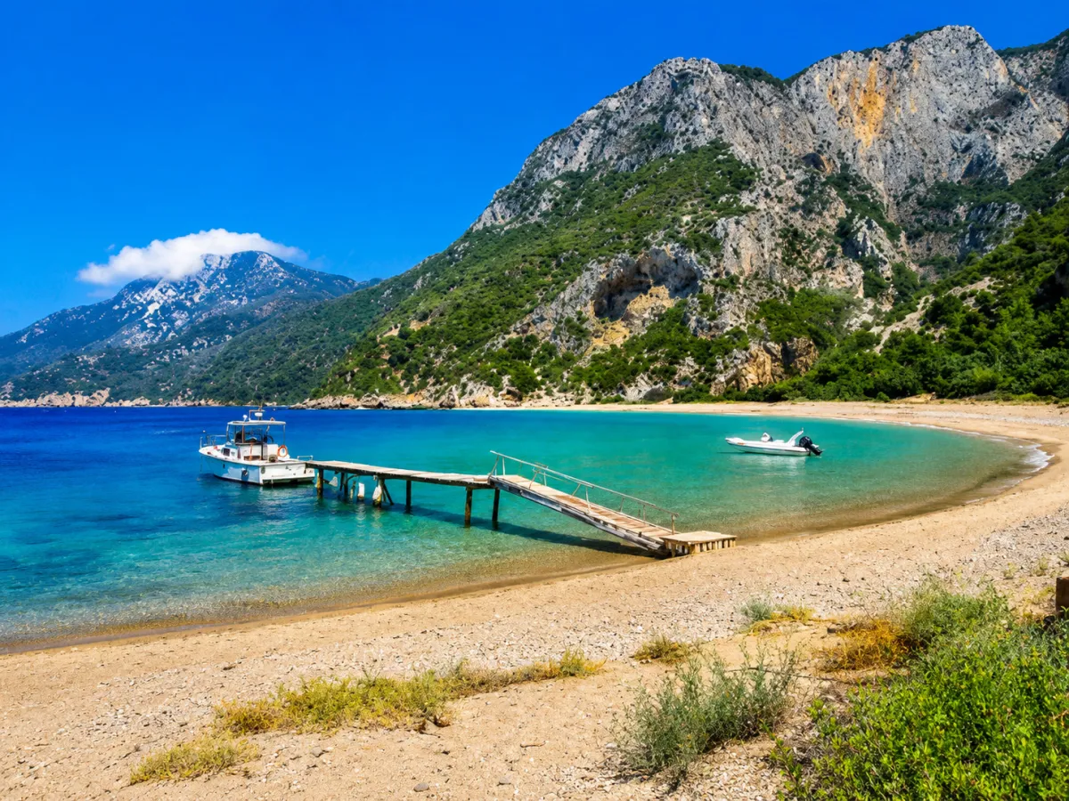
An imposing sandy and pebbly coastline at the mouth of Kakoperato Gorge, within a protected Natura 2000 area
Megalo Seitani is one of the most impressive and difficult-to-reach beaches on Samos. It is located on the northwestern side of the island, west of Karlovasi and Potami Beach, in a large natural bay formed in front of the mouth of Kakoperato Gorge.
The long, curved coastline, turquoise-green water, steep rocky slopes and dense vegetation create a landscape entirely different from the island’s organised beaches. The absence of road access to the shore and the inclusion of the area within the Natura 2000 network have helped preserve its natural character.
📍 Location
Megalo Seitani Beach is located in northwestern Samos, within the wider area of Mount Kerkis and the western coastline of Karlovasi. It lies beyond Mikro Seitani, along the coastal trail that begins at the western end of Potami Beach.
The beach is not directly connected to a paved or unpaved road. Visitors must cover the final distance on foot or approach the coast from the sea using a suitable boat, sea kayak or seasonal private excursion.
🗺️ The shape of the bay
Megalo Seitani forms a broad natural curve in front of Kakoperato Gorge. Steep limestone slopes rise behind the beach, while lower areas are covered with pine trees, cypress trees, cedars, olive trees, shrubs and dense Mediterranean vegetation.
The mouth of the gorge creates a dramatic opening towards the sea. When viewed from a boat, the landscape clearly reveals the narrow valley descending between the mountainous slopes and ending behind the beach.
👿 The name Seitani and Kakoperato Gorge
The name “Seitani” is associated with the Turkish word şeytan, meaning “devil”. According to local tradition, the unusual sounds created by the wind and waves inside the rocks and cavities of the area led earlier sailors to believe that the place had something mysterious or threatening about it.
The name Kakoperato is linked to the same tradition and describes the rough and difficult terrain of the gorge. This explanation forms part of local oral tradition and should not be presented as a fully documented historical fact.
🏖️ Dimensions and composition of the coastline
The beach is approximately 470 metres long and has an average width of around 17 metres, making it considerably larger than neighbouring Mikro Seitani.
The shore consists of sand, coarse pale-coloured sand and small pebbles. The balance between sand and pebbles may change depending on winter wave action and the movement of coastal material.
It is therefore inaccurate to describe Megalo Seitani exclusively as a beach with large pebbles. In many photographs and records, extensive sandy sections are visible, particularly along the central part of the coastline.
🌊 The water and seabed
The water is clean and transparent, with colours ranging from bright blue to turquoise and deep blue. The appearance of the sea is strongly influenced by the wind, wave conditions and depth.
The seabed combines sand, pebbles and rocky sections, especially towards the edges of the bay. Entry into the water may be relatively gradual in some areas, but the beach should not be described overall as shallow or completely safe for very young children.
After strong wave action, local slopes, sudden changes in the seabed and powerful backwash may form across the sand and pebbles.
🌬️ Wind and waves
Megalo Seitani is open to the northern Aegean and is affected by northerly and northwesterly winds. Many records note that the beach often experiences waves, although on days with light winds the sea can be remarkably calm.
The large natural bay does not provide the same protection as a narrow and enclosed cove. Before beginning the hike, visitors should check not only the temperature but also the wind and wave forecast, as the return journey requires another long walk.
During strong wave conditions, entering and especially leaving the sea can become difficult, even for confident swimmers.
🛟 Swimming safety
There is no lifeguard, organised supervision or direct vehicle access for emergency services at the beach. Its distance from the nearest road means that assistance may take considerable time to arrive.
When waves are present, inexperienced swimmers and young children should avoid entering the sea. Visitors should also avoid swimming alone or moving far from the shore without a visible swimming buoy.
Clear water alone is not an indication of safe conditions. Visitors must assess the wind, direction of the waves, their physical ability and their capacity to return safely to shore.
🌿 Natura 2000 protected area
Mikro and Megalo Seitani lie within the Special Area of Conservation GR4120003, officially named “Mount Kerketeus – Mikro and Megalo Seitani – Kastania and Lekka Forest – Cape Katavasis – Limenas”.
This Natura 2000 area covers approximately 6,683 hectares and includes mountain landscapes, forests, gorges, coastal habitats and the marine zone surrounding the Seitani beaches. The area also overlaps with the Special Protection Area GR4120008 – Mount Kerkis.
Inclusion in the Natura 2000 network does not mean that visiting or swimming is prohibited. It does mean, however, that all activities must take place without damaging habitats, disturbing wildlife, lighting fires, leaving rubbish or creating temporary or permanent structures.
🦭 The Mediterranean monk seal Monachus monachus
The wider Seitani area is an important habitat for the Mediterranean monk seal Monachus monachus, a protected and endangered marine mammal. Its presence is one of the reasons the region has significant ecological value and has been included in habitat-protection programmes for the Mediterranean monk seal.
The seals use isolated beaches and sea caves for resting and breeding. Visitors should not assume that sightings are certain or frequent. The monk seal is a wild and shy animal that usually avoids human activity.
⚠️ What to do if a seal appears
If a Mediterranean monk seal appears in the water or on the shore:
🦭 Do not approach or attempt to touch it.
📸 Do not surround it for photographs and do not use flash at close range.
🔇 Reduce noise and move away calmly.
🐕 Keep pets on a lead and away from the animal.
🚤 Do not chase it with a boat, kayak or other watercraft.
🪨 Do not enter caves or rock cavities that may be used as shelters.
The isolation of the coastline is particularly important for species such as Monachus monachus, which seek quiet beaches and sea caves for resting, giving birth and caring for their young.
🌳 Natural shade
Contrary to the original text, Megalo Seitani offers natural shade in certain areas. Behind the beach is a dense group of coastal trees and cedars that provides shade during summer.
The shade does not cover the entire coastline, and the best areas may already be occupied. Because the sun changes position and visitors usually remain for several hours, everyone should bring a hat, sunscreen and preferably a lightweight beach umbrella.
Visitors must not build temporary structures or cut branches to create shade.
🏖️ Organisation and facilities
Megalo Seitani is a completely unorganised beach. There are no sun loungers, umbrellas, beach bars, restaurants, canteens, public toilets, showers, changing rooms or lifeguard services.
There are also no rubbish bins with regular collection. Every visitor must carry away all waste, including organic remains, cigarette ends and empty bottles.
The lack of facilities is an essential part of the character of the beach, but it requires proper preparation before departure.
💧 Water and supplies
The official hiking route information mentions a drinking-water tap on the eastern side of the beach. However, visitors should not rely exclusively on it, as the supply of a remote water source may be affected by the season, drought or a technical problem.
Every hiker should begin the route already carrying:
💧 At least enough water for the outward journey, stay and return
🥪 Food and energy snacks
🧂 Something salty to help replace electrolytes
🧴 Sunscreen
🧢 A hat
🕶️ Sunglasses
🗑️ A bag for all rubbish
🩹 A small first-aid kit and supplies for blisters or minor injuries
🥾 The hiking route from Potami
The officially recorded route Potami – Mikro Seitani – Megalo Seitani is approximately 3.8 kilometres long, with an estimated duration of 1 hour and 40 minutes in each direction and a total elevation change of around 286 metres. It begins at the western end of Potami Beach and initially follows the coastal road westwards.
The trail then climbs and continues parallel to the coastline, passing through old olive groves, pine trees and cypress trees. Hikers first reach the small beach of Mikro Seitani, after which the route continues towards Megalo Seitani.
Including the return journey, the basic route covers at least 7.6 kilometres and approximately 3 hours and 20 minutes of actual walking, without counting stops, swimming or possible delays.
⏱️ Realistic duration of the excursion
The time required for the trail depends on:
🥾 Physical fitness
🎒 The weight of the backpack
☀️ The temperature
📸 Stops for rest and photographs
🌿 The condition and signage of the trail
👨👩👧👦 The presence of children or inexperienced hikers
For an average visitor, it is safer to allow 1 hour and 30 minutes to 2 hours in each direction and to treat the visit as an excursion lasting several hours or almost a full day.
🪨 Difficulty of the trail
The official route is recorded as having low technical difficulty, but this does not mean it is suitable for flip-flops or for people without basic physical fitness. It includes ascents, descents, stones, narrower sections and exposed stretches under the sun.
After rain, the ground may become slippery, while summer heat significantly increases fatigue and the need for water.
The following are considered essential:
👟 Sports shoes with good soles or hiking shoes
🎒 A lightweight and properly fitted backpack
📱 A fully charged mobile phone
📍 An offline map or GPX file
🔋 A power bank
🩹 A basic first-aid kit
🌄 The route via Mikro Seitani
Mikro Seitani is the first beach reached by hikers. It is a smaller and narrower cove with white pebbles, high cliffs and limited space.
From there, the trail continues westwards, alternating between shaded and exposed sections, until the broad curve of Megalo Seitani is revealed.
A stop at Mikro Seitani is useful for resting, but visitors must manage their time carefully to avoid returning along the trail after sunset.
🥾 Continuing towards Drakei
From Megalo Seitani, hikers can continue along the marked Route 6 towards the village of Drakei. This section is approximately 4.2 kilometres long.
This option should not be chosen spontaneously. Hikers must have organised:
🚗 Transport from Drakei
🗺️ A map or GPX file for the full route
💧 Additional water
⏱️ Enough time before sunset
📶 An alternative plan in case of fatigue or changing weather
Without arranged transport, the safest option for most visitors is to return along the same trail towards Potami.
⛵ Access from the sea
The beach can also be approached from the sea by private or chartered boat, traditional excursion vessel or sea kayak. Seasonal private excursions may operate from Karlovasi Port, but there is no guaranteed daily public service.
Safe approach depends on:
🌬️ The northerly wind
🌊 Wave height
⚓ The type and size of the boat
📅 Excursion availability
🚤 The experience of the operator
During wave conditions, disembarking onto the sandy and pebbly coast may be difficult or the trip may be cancelled. The return journey must be agreed in advance and should never depend on the chance arrival of another boat.
🅿️ Parking and starting point
There is no parking area at Megalo Seitani because no road reaches the beach.
Visitors choosing the hiking route leave their vehicles in the Potami area or at a permitted location close to the western beginning of the trail. The exact point accessible by vehicle may depend on local road conditions and signage.
Vehicles must not be left where they block traffic, private property, emergency access or the entrance to the trail.
👨👩👧👦 Is it suitable for families?
Megalo Seitani is not a typical family beach and is not suitable for families with babies or very young children.
The main difficulties are:
❌ The long outward and return hike
❌ The absence of organised facilities
❌ The lack of a lifeguard
❌ The frequent presence of waves
❌ The distance from road and medical assistance
❌ The need to carry water, food and equipment
Families with older children who have hiking experience may undertake the excursion only with good preparation, suitable footwear, mild temperatures and calm sea conditions.
🤿 Swimming and snorkelling
On days with calm sea conditions, the clear water and rocky edges of the bay offer good opportunities for snorkelling.
Close to the sides of the bay, visitors may observe rocks, stony sections and small marine life. The central part of the bay is more exposed and should not be explored far from the shore when waves or boats are present.
There is no organised equipment, instructor or protected swimming zone. Every activity is undertaken at personal responsibility and according to the conditions of the day.
🏖️ Naturism
Because of its isolation and considerable length, Megalo Seitani is also used by visitors who practise naturism. It is not, however, an officially designated naturist beach.
The large amount of available space generally allows visitors to choose more distant sections of the coastline while respecting other beach users and the natural environment.
⛺ Wild camping
The previous statement that Megalo Seitani is “ideal for wild camping” must be removed.
Pitching tents and wild camping on foreshores, beaches and public spaces are prohibited under Greek law. In addition, Megalo Seitani lies within a protected Natura 2000 area and an important habitat of the Mediterranean monk seal, making prolonged occupation, fires, intense night-time activity and the accumulation of waste particularly harmful.
The beach should be presented as a destination for a day visit and not as a camping location.
🔥 Extreme caution with fire
Do not light fires, use camping stoves or set up improvised barbecues either on the shore or beneath the trees. The area is surrounded by flammable Mediterranean vegetation and there is no direct road access for fire engines.
Even a small piece of charcoal, a match or a cigarette end could cause devastating damage to one of the most important protected natural areas of Samos.
🌿 Protecting the beach
Every visitor should:
🗑️ Remove all rubbish.
🚭 Never leave cigarette ends in the sand or among the pebbles.
🌱 Avoid cutting branches or trampling low coastal vegetation.
🪨 Avoid moving large stones to create permanent structures.
🔊 Avoid loud music and excessive noise.
🐕 Keep dogs under control.
🦭 Avoid approaching sea caves that may be used by seals.
Protection of the area depends not only on the absence of large tourism facilities but also on the behaviour of every individual visitor.
📸 Photography and views
The first panoramic view of Megalo Seitani from the trail is one of the most impressive points of the route. From above, visitors can see the curve of the pale-coloured coastline, the turquoise water and the steep slopes of the gorge.
Morning and midday light highlight the clarity of the water, while later in the day the surrounding slopes take on warmer tones. The beach faces north, so the sunset does not always appear directly in front of the coastline, but the late-afternoon light remains especially impressive.
📍 Approximate access details
🚗 Approximately 2.5–3 km from Karlovasi to the Potami area
🥾 Approximately 3.8 km of hiking from Potami to Megalo Seitani
⏱️ Approximately 1 hour and 40 minutes in each direction, without long stops
🔄 At least 7.6 km of total hiking when returning by the same route
🥾 Approximately 4.2 km from Megalo Seitani to Drakei via Route 6
⛵ Possible access by sea from Karlovasi, depending on weather and boat availability
Times and distances may vary depending on the exact parking location, the condition of the trail, physical fitness and the number of stops.
🚶 What to see and do
🥾 Follow the complete coastal route from Potami through Mikro Seitani.
📸 Photograph the beach from the higher sections before the final descent.
🌊 Swim only when sea conditions are safe.
🤿 Explore the rocky edges of the bay with a mask during calm conditions.
🌳 Rest in the natural shade of the trees behind the shore.
🥪 Organise a daytime picnic and carry away all rubbish.
🦭 Observe nature without approaching caves or wild animals.
⛵ Consider access by sea when you do not wish or are unable to complete the hike.
🌅 Begin the return journey well before sunset.
💡 Useful tips
👟 Do not attempt the trail in flip-flops or unsuitable footwear.
💧 Carry plenty of water even if you know there is a tap in the area.
☀️ Avoid hiking during the hottest midday hours.
🌬️ Check the northerly wind and wave forecast before setting out.
📍 Download the map or GPX file for offline use.
📱 Carry a fully charged mobile phone and a power bank.
🩹 Bring a basic first-aid kit and supplies for minor injuries.
🛟 Do not swim alone when waves are present.
🌙 Do not leave the return journey until after sunset.
🔥 Do not light fires or pitch a tent.
🗑️ Take away everything you brought to the beach.
🏷️ Characteristics of the beach
🏖️ Large natural coastline approximately 470 metres long
📏 Average width of around 17 metres
🏝️ Combination of sand, coarse sand and small pebbles
🌊 Clear and transparent turquoise-green water
🌬️ Exposure to northerly winds and frequent waves
🏔️ Dramatic location in front of Kakoperato Gorge
🌳 Natural shade from trees and cedars along sections of the beach
🌿 Protected Natura 2000 area
🦭 Important habitat for the Mediterranean monk seal Monachus monachus
🥾 Access via a marked hiking trail
⛵ Possible access from the sea
🚫 No organised tourism facilities
🛟 No lifeguard
🏖️ Also used by naturists without official designation
🧘 Ideal for nature lovers and hikers with proper preparation


Add new comment