
Ydroussa of Samos
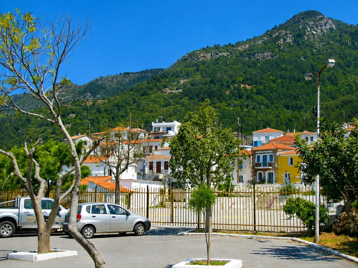
🏞️ Ydroussa, Samos – The Village of Springs and Vineyards
Ydroussa is a lush, semi-mountainous village in northwestern Samos, located inland, southeast of Karlovasi and west of the Karvounis mountain massif. It stands at an altitude of approximately 220 metres and lies about 6.5 kilometres from Karlovasi.
Vineyards, olive groves, gardens, wooded areas and natural springs surround the settlement, while several locations offer views towards the Karlovasi plain and the northern coast of Samos. The landscape and abundance of water have shaped both the village’s present name and its strong agricultural identity.
Administratively, Ydroussa forms the Municipal Community of Ydroussa, which belongs to the Municipal Unit of Karlovasia, the Municipality of Western Samos, the Regional Unit of Samos and the North Aegean Region. According to the 2021 census, the village has 355 permanent residents.
📍 Location and Character
Ydroussa lies in the inland countryside of northwestern Samos, between the wider Karlovasi area and the western side of the Karvounis mountain massif.
To the north, it is connected by road with Kontakeika, while routes to the south and southwest lead towards Kontakeika, Platanos and other villages of western Samos. The surrounding landscape is characterised by gentle slopes, cultivated land, small streams and dense vegetation.
The settlement remains active throughout the year and preserves the character of an authentic rural village, closely connected with farming, viticulture and the area’s abundant water resources.
📜 History and the Village’s Former Name
Ydroussa is one of the oldest settlements of modern Samos. Its existence is documented in a record dating from 1625, in which it appears under its former name, “Fournoi”. The creation of the village is associated with the repopulation of the island, which began during the second half of the 16th century.
The name “Fournoi” is mainly linked to the ovens and kilns once used for making and firing pottery. Ceramic production continued in the area until the beginning of the 20th century, while earlier historical references also associated the region with ancient Hypnousia, as the Greek word “hypnos” could refer to an oven or kiln.
In 1918, the settlement was designated as the administrative seat of the Community of Fournoi. On 9 February 1950, it was officially renamed Ydroussa, a name inspired by the abundance of springs and flowing water in the surrounding area.
🏛️ Administrative Development
Ydroussa remained the seat of an independent community until 1997, when the implementation of the Kapodistrias administrative reform incorporated it into the Municipality of Karlovasia.
In 2010, it became part of the unified Municipality of Samos and, following the new administrative division of the island in 2019, it was incorporated into the Municipality of Western Samos.
⛪ The Church of Agioi Athanasios and Kyrillos
The principal religious and architectural landmark of Ydroussa is the parish church dedicated to Agioi Athanasios and Kyrillos, dating from 1782.
The church is especially notable for its wall paintings, completed in 1804 at the expense of Dimitrios Chatzikatevainis. It is one of the village’s most important historic buildings and remains closely connected with the religious and social life of the local community.
The joint feast of Agioi Athanasios and Kyrillos is celebrated on 18 January.
🕊️ The Church of the Dormition in Petalouda
In the green area known as Petalouda, outside the village, stands the old chapel of the Dormition of the Virgin Mary, dating from 1663.
The small religious monument preserves notable wall paintings and is one of the oldest surviving ecclesiastical sites in the wider area. Its location among dense vegetation and flowing water places it along one of the most attractive natural routes around Ydroussa.
🚰 Springs and Flowing Water
Water is a defining element of Ydroussa’s identity. The numerous springs in the area served the daily needs of the inhabitants, irrigated cultivated land and supported the local agricultural economy for centuries.
Fountains, streams and natural water sources create a cool microclimate and sustain the rich vegetation surrounding the village. Their presence was so characteristic that it inspired the renaming of the settlement from Fournoi to Ydroussa.
🏡 Traditional Architecture and Neighbourhoods
The historic centre of the village preserves several features of traditional Samian architecture. Stone-built and plastered houses, tiled roofs, wooden frames, external staircases, narrow lanes and courtyards filled with flowers and grapevines shape the appearance of Ydroussa.
The houses follow the natural contours of the land, creating small neighbourhoods at different levels. Older buildings, restored homes and stone walls recall the agricultural and craft-based history of the settlement.
🏺 The Former Pottery Tradition
The old name Fournoi preserves the memory of the pottery activity that once developed in the area. Local craftsmen produced clay vessels and other ceramic objects, which were fired in kilns around the village.
The production of pottery appears to have continued until around 1900, providing an additional source of income alongside agriculture. This tradition connects Ydroussa with a lesser-known aspect of Samian folk craftsmanship.
🍇 Vineyards and Samian Muscat
Viticulture is one of Ydroussa’s most important traditional activities. Vineyards extend around the village, many of them planted on small agricultural plots and stone terraces.
The white small-berried Muscat grape is cultivated in the area and is the characteristic variety used to produce the renowned wines of Samos. At the Evgenikou Vineyard, south of the entrance to the village, Muscat grapes continue to be cultivated largely by hand, preserving the traditional character of Samian viticulture.
The grape harvest remains an important period for the local community, connecting agricultural production with family life, cooperation and the island’s long winemaking tradition.
🫒 Rural Life and Cultivation
Alongside vineyards, local residents cultivate olive trees, vegetables and fruit trees. Orchards and family gardens around the houses maintain the agricultural character of the village.
Tobacco cultivation also played an important role in the local economy in the past. Although tobacco production gradually declined, vineyards, olive groves and irrigated fields continue to define the surrounding countryside.
🌳 Nature and the Route to Petalouda
The countryside around Ydroussa is suitable for walks among vineyards, olive groves, wooded areas and small streams.
The route towards Petalouda is particularly interesting, passing through dense vegetation and locations with flowing water. The circular trail has been used by hiking groups and highlights the natural environment surrounding the village.
Rural roads also provide different views towards Karlovasi, the nearby cultivated areas and the Karvounis mountain massif.
🎉 The Feast of Agios Ioannis
The village’s main summer celebration takes place on 29 August, the feast of the Beheading of Saint John the Baptist.
The traditional festival of Ydroussa is one of the well-known local celebrations of western Samos and attracts residents and visitors from different parts of the island.
🌿 What to See
During your visit to Ydroussa, take time to discover:
✅ The historic church of Agioi Athanasios and Kyrillos
✅ The chapel of the Dormition of the Virgin Mary in Petalouda
✅ The old neighbourhoods and traditional houses
✅ The narrow lanes and courtyards covered with grapevines
✅ The springs and locations with flowing water
✅ The vineyards of Samian Muscat
✅ The rural routes surrounding the village
✅ The views towards the Karlovasi area and the sea
🚶 The Visitor Experience
Ydroussa is not centred around one major attraction. Its appeal lies in walking through its neighbourhoods, discovering its springs, churches and vineyards and experiencing the peaceful rhythm of everyday village life.
The village is particularly suitable for visitors interested in local history, traditional architecture, viticulture, photography and gentle walks through nature.
Approximately 60 to 90 minutes are recommended for a relaxed exploration of the village and its nearby points of interest.
📆 When to Visit
Spring: The vegetation is dense, the flowing water is more visible and temperatures are ideal for walking.
Summer: Morning and late afternoon visits are preferable, when the narrow lanes and courtyards remain cooler.
Late August: The main festival of Agios Ioannis takes place on 29 August.
Autumn: The grape harvest highlights the village’s winemaking tradition and agricultural identity.
Winter: The village retains its peaceful atmosphere and daily rhythm, while water and vegetation dominate the surrounding landscape.
🧭 How to Get There
From Karlovasi, follow the paved road towards the inland countryside of northwestern Samos. Ydroussa lies approximately 6.5 kilometres away, along a gently uphill route with moderate bends.
From Kontakeika, follow the paved road southwards. Ydroussa is reached after approximately 4 kilometres.
The streets within the historic centre are narrow. Parking in a suitable location and continuing the visit on foot is the most practical option.
ℹ️ Useful Information
✅ Administrative community: Municipal Community of Ydroussa
✅ Municipal unit: Karlovasia
✅ Municipality: Western Samos
✅ Population in 2021: 355 residents
✅ Altitude: Approximately 220 metres
✅ Distance from Karlovasi: Approximately 6.5 kilometres
✅ Distance from Samos Town: Approximately 33 kilometres
✅ Distance from Marathokampos: Approximately 19 kilometres
✅ Postal code: 83200
✅ GPS coordinates: 37.779059, 26.747654
✅ Road access: Paved road
✅ Suggested visiting time: Approximately 60–90 minutes
✅ Ideal for: History, churches, vineyards, photography and nature walks




Add new comment