
Kontaiika Village
🌿 Kontaika, Samos – The Green Inland Community Near Karlovasi
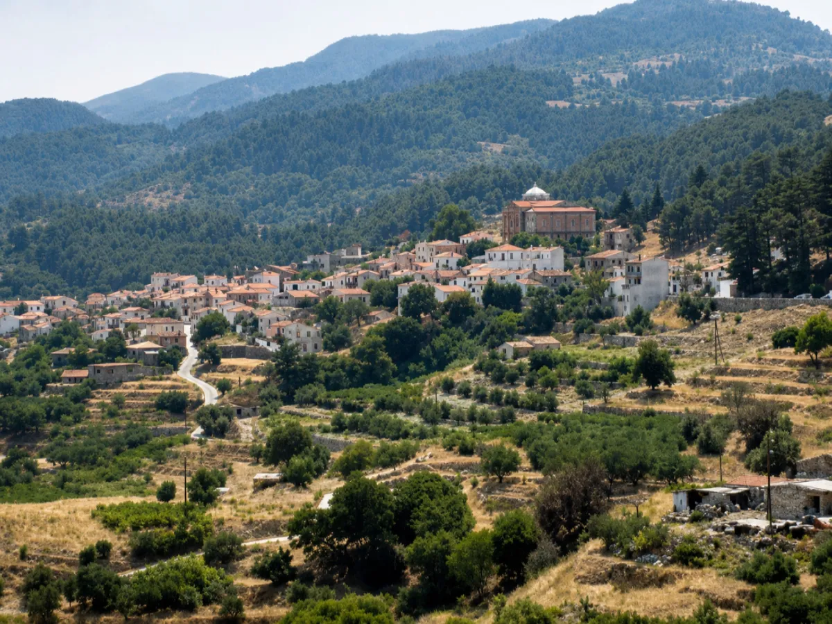
The Municipal Community of Kontaika lies in northwestern Samos, in the inland countryside south of Karlovasi. Its administrative seat is the village of Kontaika, built among the green foothills of Mount Ampelos, also known as Karvounis.
The village occupies a sheltered position at an altitude of approximately 323 metres. Hills, olive groves, vineyards and cultivated land surround its neighbourhoods, while the natural terrain largely conceals it from the coast and creates a peaceful rural environment.
According to the 2021 census, Kontaika has 292 permanent residents. It belongs to the Municipal Unit of Karlovasia, within the Municipality of Western Samos.
📍 Location and Natural Environment
Kontaika is situated on the northwestern foothills of Karvounis, between cultivated slopes, small valleys and densely vegetated hills. Its inland position provides a noticeably different atmosphere from the coastal areas around Karlovasi.
The surrounding landscape includes olive groves, vineyards, vegetable gardens, fruit trees and older agricultural terraces. The combination of cultivated land and natural vegetation reflects the long-standing relationship between the community and the fertile countryside of western Samos.
From the higher parts of the village and the surrounding rural roads, views open towards the neighbouring hills, Ydroussa and the wider Karlovasi region. The geographical position of Kontaika is approximately 37.7566, 26.7395.
🏛️ Administrative Identity of the Community
The Municipal Community of Kontaika belongs to the Municipal Unit of Karlovasia in the Municipality of Western Samos. The municipality forms part of the Regional Unit of Samos in the North Aegean Region.
The village of Kontaika is both the administrative seat and the officially recorded settlement of the community.
The community was officially established on 21 September 1918, under the name Community of Konteika. On 16 October 1940, the official name of both the village and the community was corrected to Kontaika.
In 1997, the community became part of the Municipality of Karlovasia. In 2010, it was incorporated into the unified Municipality of Samos and, since 2019, it has belonged to the Municipality of Western Samos.
📝 The Name Kontaika
According to local tradition, the village was named after Konstantinos Kontos, a shepherd who moved to the area from the village of Platanos around the middle of the 18th century.
He settled with his family on the fertile slopes, and additional houses were gradually built around this first family group. The name Kontaika developed from the family name Kontos, following a naming pattern also found in other villages and rural communities of Samos.
The earlier official spelling was recorded as Konteika. The form Kontaika was formally adopted in 1940 and remains the present administrative name.
📜 The Foundation and Development of the Village
The development of Kontaika is connected with the gradual settlement of the inland slopes behind Karlovasi during the 18th century. The protected position, available water, fertile soil and access to mountain pasture created favourable conditions for permanent habitation.
The first family settlement gradually developed into an organised agricultural village. Houses were built along the natural inclines, while cultivated plots, gardens and vineyards extended around the residential centre.
During the 19th century, the village acquired a stronger community structure, with a parish church, neighbourhoods, local institutions and an economy based primarily on agriculture. Its proximity to Karlovasi also allowed residents to trade their produce and maintain connections with the principal commercial centre of western Samos.
👥 Population and Present-Day Life
Kontaika had 292 permanent residents according to the 2021 census. The village remains inhabited throughout the year and continues to function as an active rural community close to Karlovasi.
Daily life follows a quieter rhythm than in the nearby town and coastal areas. The central part of the village serves as a meeting place for residents, particularly during summer evenings, religious celebrations and local events.
Strong ties are maintained with people from Kontaika who now live in Karlovasi, other parts of Samos or outside the island. During summer and major feast days, many return to the village, increasing activity in the neighbourhoods and central gathering areas.
🏘️ The Form and Architecture of the Village
The houses of Kontaika are distributed across the hillside, following the natural shape and inclines of the terrain. Narrow streets, small passages and stepped sections connect the central area with the older neighbourhoods.
Traditional houses with stone foundations, tiled roofs, wooden doors and windows, external stairways and flower-filled courtyards remain visible throughout the village. Many homes are surrounded by gardens, vines and small cultivated plots that preserve the connection between domestic and agricultural life.
Restored houses and newer buildings stand alongside the older residences. Despite these changes, Kontaika retains the scale and peaceful atmosphere of a traditional inland village of Samos.
⛪ The Church of the Nativity of the Virgin Mary
The parish church of Kontaika is dedicated to the Nativity of the Virgin Mary and forms the principal architectural and religious landmark of the community.
Built in 1895, the large church is distinguished by its dome, stone exterior and prominent position within the village. Its total area is approximately 450 square metres, reflecting the population and economic activity of Kontaika during the late 19th century.
The church celebrates its main feast on 8 September, the Feast of the Nativity of the Virgin Mary. The day traditionally brings residents, families and visitors together for religious services and local celebrations.
⚠️ The Earthquake of 2020
The Church of the Nativity of the Virgin Mary suffered serious damage during the powerful earthquake that struck Samos on 30 October 2020.
The earthquake affected numerous churches, traditional houses and historic buildings across northwestern Samos, particularly in Karlovasi and the surrounding villages. Kontaika was among the communities where significant structural damage was recorded.
A detailed architectural survey and restoration study were subsequently prepared for the church and approved by the competent archaeological and earthquake-rehabilitation authorities.
🫒 Agriculture and Rural Economy
Agriculture has shaped the economy and identity of Kontaika since the village’s earliest development. The fertile slopes and mild climate supported a variety of crops cultivated on small family-owned plots.
Olive cultivation and olive-oil production remain important, while vineyards historically connected the community with the celebrated wine tradition of Samos. Vegetable gardens, fruit trees and household farming also contributed to the local economy and the daily needs of families.
Tobacco was cultivated in earlier periods, when it formed part of the agricultural production of several communities in western Samos. Although its cultivation has now disappeared, it remains part of the village’s agricultural history.
The cultivated terraces, olive groves and vineyards surrounding Kontaika continue to reflect the traditional organisation of the countryside, even though agricultural activity has declined compared with previous generations.
🍇 Vineyards and Samian Wine
Viticulture holds a special place in the history of Kontaika. Vineyards were established on the sunny slopes around the village, where the terrain and climate offered favourable conditions for growing grapes.
The grapes were used for household wine production and supplied the broader winemaking economy of Samos. Small vineyards and old agricultural terraces remain visible around the village, preserving part of this historic landscape.
The relationship between Kontaika and wine is not limited to production. It is also expressed through family traditions, seasonal agricultural work and the social customs associated with the grape harvest.
🌿 Nature and Rural Exploration
The countryside around Kontaika is characterised by dense vegetation, cultivated hills and quiet rural roads. The landscape is especially green during winter and spring, when seasonal water, wildflowers and fresh vegetation transform the slopes.
Several agricultural roads begin around the village and lead towards the interior of Mount Ampelos. Some are suitable for ordinary vehicles only for a limited distance, while rougher sections require a suitable four-wheel-drive vehicle.
These routes provide access to olive groves, vineyards, woodland and elevated viewpoints. They are suitable for peaceful exploration, nature photography and short walks, provided visitors remain on clearly accessible roads and paths.
🗺️ Exploring the Surrounding Villages
Kontaika can be included in a wider road trip through the inland communities of western Samos. Its position allows visitors to combine it with Ydroussa, Platanos, Kosmadaioi and Karlovasi.
The route passes through a changing landscape of vineyards, olive groves, forested slopes and traditional villages. Each community has a distinct character, while together they reveal the agricultural and mountainous identity of northwestern Samos.
Kontaika is especially convenient for visitors staying in Karlovasi who wish to discover the quieter countryside without travelling far from the town.
🌿 What to See
During your visit to the Municipal Community of Kontaika, take time to discover:
✅ The central area and the older neighbourhoods
✅ The Church of the Nativity of the Virgin Mary
✅ The church’s stone exterior and characteristic dome
✅ The narrow lanes and hillside passages
✅ The traditional houses and flower-filled courtyards
✅ The olive groves and vineyards surrounding the village
✅ The rural roads towards Mount Ampelos
✅ The elevated viewpoints over the surrounding hills
✅ The agricultural landscape between Kontaika and Ydroussa
🚶 The Visitor Experience
A visit can begin in the central part of the village and continue towards the Church of the Nativity of the Virgin Mary. From there, the narrow streets lead through the older neighbourhoods, past traditional houses, gardens and small cultivated plots.
The village is best explored slowly and on foot. Several streets have uphill sections, but the distances within the residential centre are short and the limited traffic creates a relaxed environment.
After exploring the village, visitors can follow one of the nearby rural roads or continue their journey towards Ydroussa, Platanos or Karlovasi. Approximately 45–60 minutes are sufficient for a simple walk through Kontaika, while a longer route through the surrounding countryside can extend the visit to two or three hours.
📆 When to Visit
Spring: The best season for green hills, wildflowers, vineyards, flowing seasonal water and mild temperatures.
Summer: Suitable for an afternoon or evening visit, when the village is cooler and the central area becomes more active.
8 September: The most important religious date for the community, marking the Feast of the Nativity of the Virgin Mary.
Autumn: Ideal for peaceful walks, rural photography and landscapes connected with vineyards and olive cultivation.
Winter: Offers an authentic view of everyday village life, although rain and mist may affect the mountain roads.
🧭 How to Get There
Kontaika is accessible by paved road through the wider Karlovasi area. The route climbs gradually into the inland hills and includes several bends, but it is suitable for a conventional car.
The village lies approximately:
✅ 6–7 kilometres from Karlovasi
✅ 29 kilometres from Samos Town
✅ 38 kilometres from Pythagoreio
✅ 39–40 kilometres from Samos International Airport
The surrounding agricultural and mountain roads may include unpaved or rough sections, where a four-wheel-drive vehicle can be necessary.
ℹ️ Useful Information
✅ Official name: Municipal Community of Kontaika
✅ Administrative seat: Kontaika
✅ Settlement within the community: Kontaika
✅ Character: Traditional semi-mountainous agricultural community
✅ Location: Northwestern Samos, inland from Karlovasi
✅ Mountain area: Foothills of Mount Ampelos – Karvounis
✅ Municipal unit: Karlovasia
✅ Municipality: Western Samos
✅ Regional unit: Samos
✅ Region: North Aegean
✅ Establishment of the community: 21 September 1918
✅ Adoption of the present official name: 16 October 1940
✅ Population in 2021: 292 permanent residents
✅ Altitude: Approximately 323 metres
✅ Parish church: Nativity of the Virgin Mary
✅ Year of church construction: 1895
✅ Church feast day: 8 September
✅ Main traditional activities: Olive cultivation, viticulture and vegetable farming
✅ Historic crop: Tobacco
✅ Distance from Karlovasi: Approximately 6–7 kilometres
✅ Postal code: 83200
✅ GPS coordinates: 37.7566, 26.7395
✅ Road access: Paved road
✅ Suggested visiting time: Approximately 1–3 hours
✅ Ideal for: Traditional architecture, rural landscapes, photography, vineyards, nature and peaceful exploration


Add new comment