
Saint Kyriaki of Marathokampos
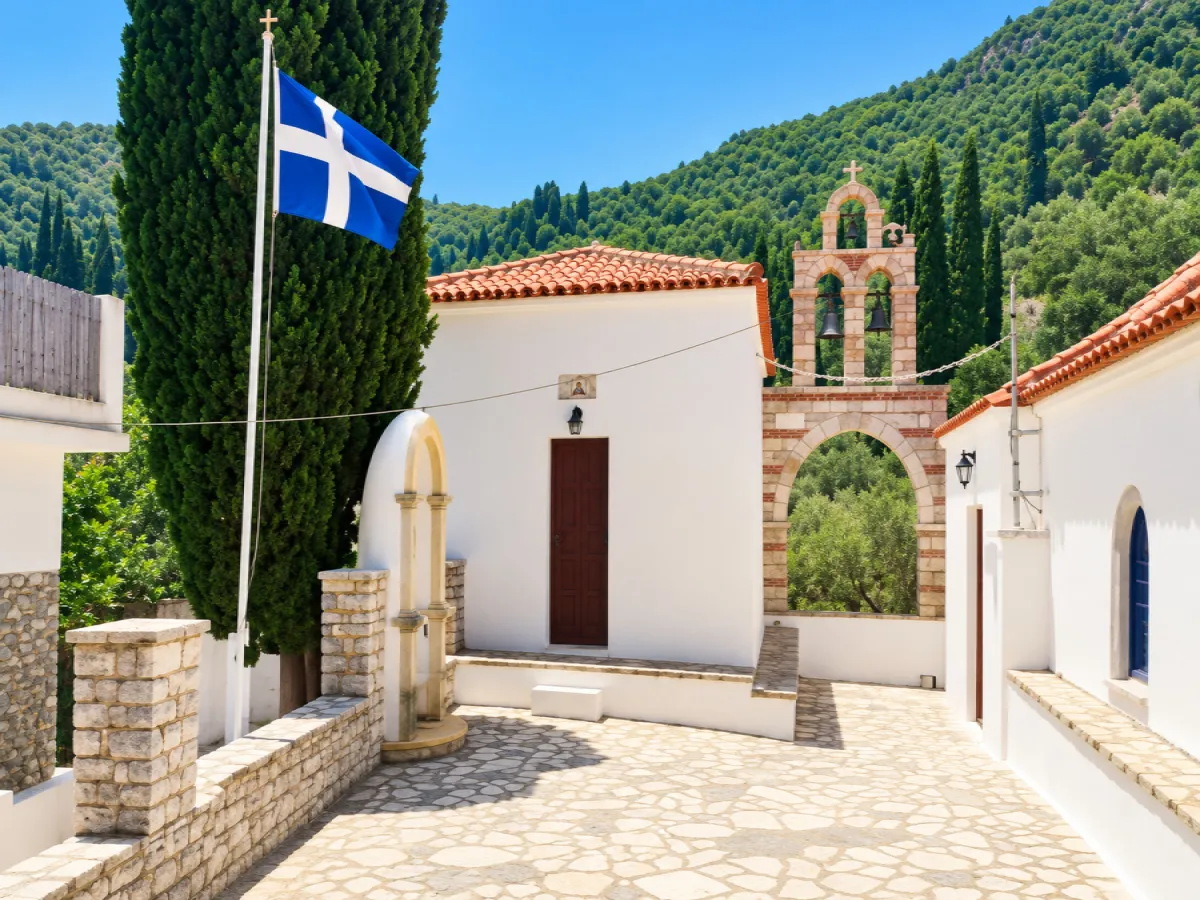
🏡 Agia Kyriaki of Marathokampos, Samos – The Small Settlement at the Foot of Kerkis
Agia Kyriaki is a small settlement in southwestern Samos, built on the southern foothills of the imposing Mount Kerkis, within a quiet valley that descends towards Limnionas and the Aegean Sea. With very limited modern development, agricultural land, olive trees, low vegetation and the mountain dominating the horizon, it retains one of the most peaceful characters in the wider Marathokampos area.
The settlement never developed into a large village and today has only a few dozen permanent residents. Its importance lies mainly in its location: between the mountainous interior of Kerkis and the southwestern coast of Samos, close to old agricultural paths, religious monuments and an area with a long tradition of asceticism and monastic life.
Agia Kyriaki is ideal for visitors who want to discover a different side of Samos, away from the busy coastal settlements. Its small scale, historic church, old buildings and direct relationship with the natural landscape of Kerkis create a place suitable for peaceful exploration, photography and combination with the surrounding hiking and coastal routes.
📍 Location and geographical character
Agia Kyriaki is located in southwestern Samos, on the southern foothills of Mount Kerkis, within a small valley that opens towards the sea and the Limnionas area.
The settlement lies at an elevation of approximately 100 metres and is surrounded by hills, rocky slopes and agricultural land.
Its geographical position creates a characteristic combination of:
✅ Low slopes of Kerkis
✅ Olive groves
✅ Small cultivation areas
✅ Mediterranean shrub vegetation
✅ Rocky formations
✅ Small streams
✅ Agricultural roads and old paths
✅ Openings with views towards the southwestern coast
Limnionas is located approximately 1.5 kilometres southeast, while Marathokampos lies about 7 kilometres northeast.
🏛️ Administrative identity
Agia Kyriaki belongs to:
✅ The Municipal Community of Marathokampos
✅ The Municipal Unit of Marathokampos
✅ The Municipality of Western Samos
✅ The Regional Unit of Samos
✅ The North Aegean Region
It is one of the smallest officially recognised settlements of the Municipal Community of Marathokampos and is administratively and socially connected with Marathokampos and the smaller settlements of the southwestern coast.
📜 Administrative history of the settlement
Agia Kyriaki was officially recognised as a settlement on 16 May 1928 and was incorporated into the then Community of Marathokampos.
Its administrative history followed the major changes in local government on Samos:
✅ 1928: Official recognition and incorporation into the Community of Marathokampos
✅ 1997: Under the “Kapodistrias” reform, it becomes part of the Municipality of Marathokampos
✅ 2010: Under the “Kallikratis” programme, it becomes part of the unified Municipality of Samos
✅ 2019: Following the division of the Municipality of Samos, it becomes part of the Municipality of Western Samos
Its administrative connection with Marathokampos has remained continuous from its first official recognition until today.
👥 Population and demographic development
Agia Kyriaki had a noticeably larger population during the first half of the 20th century.
The censuses record:
✅ 1928: 188 residents
✅ 1940: 180 residents
✅ 1951: 111 residents
✅ 1961: 109 residents
✅ 1971: 79 residents
✅ 1981: 87 residents
✅ 1991: 36 residents
✅ 2001: 57 residents
✅ 2011: 43 residents
✅ 2021: 33 permanent residents
The gradual population decline is associated with the wider movement of residents from small agricultural settlements towards the larger centres of Samos, Athens and abroad.
Despite its small present-day population, the settlement remains inhabited and retains active agricultural land and residences.
🏘️ The form of the settlement
Agia Kyriaki has a simple and dispersed residential structure without a dense traditional centre.
The houses and agricultural buildings are scattered around the main road and along smaller routes that follow the shape of the valley.
The landscape includes:
✅ Old stone-built houses
✅ Tiled roofs
✅ More recent rural homes
✅ Small courtyards and gardens
✅ Stone boundary walls
✅ Olive groves between the houses
✅ Old agricultural buildings
✅ Uncultivated areas that have returned to natural vegetation
Limited construction has allowed the natural landscape to remain the dominant feature of the area.
⛪ The Church of Agia Kyriaki
The church dedicated to Agia Kyriaki is the most important religious and historic landmark of the settlement.
It is located in the northwestern part of the small inhabited area and is directly connected with the name of the settlement.
Older architectural remains have been recorded at the site of the church, indicating that the location was used as a place of worship before the present form of the building.
Agia Kyriaki is celebrated on 7 July, when the small settlement experiences increased religious and social activity.
🏛️ The remains of Agios Georgios and earlier habitation
A short distance south of the settlement, remains of an old church dedicated to Agios Georgios have been recorded.
Parts of the masonry and elements of the sanctuary area are still preserved.
The site is also associated with older burial remains and is one of the places that reveal the long history of human presence in the area.
Other foundations of older structures have also been identified in the wider landscape, connected with the historic presence of monks and agricultural installations on the foothills of Kerkis.
🕯️ The ascetic tradition of Kerkis
Kerkis is one of the most important areas associated with asceticism on Samos.
The rugged terrain of the mountain, its caves, natural cavities and isolated slopes attracted monks and hermits from Byzantine times.
Organised monastic life developed in the wider area in the form of a lavra, while the steep slopes were also used for small hermitages and isolated places of prayer.
During the Middle Ages, the area experienced periods of destruction and abandonment, but monastic presence returned and continued in different forms for centuries.
🕯️ Saint Paul of Latros
Saint Paul of Latros holds an important place in the ecclesiastical tradition of Kerkis.
The Byzantine ascetic is connected with Samos during the 10th century and with the revival of monastic life on the slopes of Kerkis.
Tradition places him in cave environments of the mountain, where he lived an ascetic life and where other monks gradually gathered around him.
His presence strengthened the reputation of Kerkis as a place of isolation and spiritual life and forms an important chapter in the Byzantine history of western Samos.
🪨 Pythagoras Cave and Panagia Sarantaskaliotissa
In the wider Kerkis area, above Marathokampos, are two of the most important cave monuments of western Samos: Pythagoras Cave and Panagia Sarantaskaliotissa.
Local tradition connects Pythagoras Cave with the ancient philosopher, who is said to have taken refuge there while being persecuted by the tyrant Polycrates.
Nearby is the cave chasm of Panagia Sarantaskaliotissa, at the entrance of which stands a small Byzantine church.
Access requires hiking through mountainous and in places difficult terrain and forms a separate excursion into the mountain landscape of Kerkis.
⛰️ Mount Kerkis
Mount Kerkis, also known as Kerketeas, is the dominant natural feature of western Samos.
Its highest peak, Vigla, reaches 1,433 metres and towers above Agia Kyriaki and the southwestern coastline.
The mountain is characterised by:
✅ Steep limestone slopes
✅ Rocky summits
✅ Caves and natural shelters
✅ Pine forests
✅ Mediterranean shrubs
✅ Small springs and streams
✅ Old agricultural terraces
✅ Historic paths
Its presence determines the climate, morphology and historical development of the entire surrounding area.
🌿 Agricultural landscape and local production
Daily life in Agia Kyriaki was traditionally connected with agriculture and livestock farming.
The main activities included:
✅ Olive cultivation
✅ Fruit trees
✅ Small vegetable gardens
✅ Vineyards
✅ Goat and sheep farming
✅ Family production of olive oil
✅ Small-scale beekeeping
Olive trees remain one of the most characteristic features of the landscape today.
Old terraces and stone walls reflect the efforts of local residents to cultivate even the sloping land around the settlement.
🌊 The connection with Limnionas
The valley of Agia Kyriaki descends towards the southern coast and reaches the area of Limnionas, approximately 1.5 kilometres from the settlement.
Limnionas forms the natural coastal outlet of the area and includes a small coastal settlement and beach.
The short distance makes it easy to combine:
✅ A visit to Agia Kyriaki
✅ Exploration of the foothills of Kerkis
✅ Limnionas Beach
✅ Coastal accommodation
✅ Short hiking routes
The transition from the rocky slopes of Kerkis to the sea takes only a few minutes, creating one of the characteristic landscape contrasts of southwestern Samos.
🥾 Hiking and old paths
Agia Kyriaki lies within an area with an extensive network of agricultural roads and old paths.
The routes connect the settlement with:
✅ Limnionas
✅ Palaiochori
✅ Kallithea
✅ The lower slopes of Kerkis
✅ Small isolated coastal areas
✅ Old agricultural properties
✅ Religious and ascetic sites
There are both short routes and long hikes with considerable elevation differences.
For longer routes, suitable footwear, water, sun protection and good knowledge of the route are necessary.
🌄 Limnionas – Palaiochori – Agia Kyriaki route
One of the known hiking options in the area connects Limnionas, Palaiochori and Agia Kyriaki.
The route passes through a typical southwestern Samos landscape with:
✅ Olive groves
✅ Rocky slopes
✅ Old agricultural roads
✅ Small ravines
✅ Open views towards the Aegean Sea
✅ Isolated areas with very limited development
The complete circular route is long and demanding and is suitable for hikers with good physical condition.
📸 Photography and landscape
Agia Kyriaki does not have imposing urban monuments, but it offers a particularly interesting natural and agricultural landscape.
Photographic highlights include:
✅ The small Church of Agia Kyriaki
✅ Old houses
✅ Stone walls
✅ Olive groves
✅ The rocky slopes of Kerkis
✅ Old paths
✅ Rural courtyards
✅ The valley towards Limnionas
✅ The contrast between mountain and sea
Spring provides the greenest landscape and flowering vegetation, while afternoon light highlights the western and southern slopes of Kerkis especially well.
🌿 What to see
During a visit to Agia Kyriaki, it is worth seeing:
✅ The small settlement
✅ The Church of Agia Kyriaki
✅ Old houses and agricultural buildings
✅ The remains of Agios Georgios
✅ Stone terraces
✅ Olive groves
✅ The natural landscape of the Kerkis foothills
✅ Old paths
✅ The route towards Limnionas
✅ Nearby Palaiochori
✅ The wider cave area of Kerkis
🚗 Suggested routes
The location of Agia Kyriaki allows for several interesting combinations:
✅ Marathokampos – Agia Kyriaki: From the historic village towards the lower foothills of Kerkis.
✅ Agia Kyriaki – Limnionas: A short route from the interior to the sea.
✅ Agia Kyriaki – Palaiochori – Limnionas: Exploration of small settlements and agricultural landscapes.
✅ Agia Kyriaki – Kallithea: A route towards the western side of Kerkis and the higher villages.
✅ Marathokampos – Kerkis caves – Agia Kyriaki – Limnionas: A full-day route combining history, religious interest, mountain landscapes and sea.
🚶 Visitor experience
For a simple exploration of Agia Kyriaki, approximately 30 minutes to one hour is sufficient.
The essence of the visit lies in the peaceful atmosphere, the landscape and the feeling of a small agricultural settlement that remains away from intensive tourist development.
By adding Limnionas or Palaiochori, the route can be extended to half a day.
For hikers, Agia Kyriaki can form part of a longer full-day exploration of the southwestern side of Kerkis.
📆 When to visit
Spring: The best period for green landscapes, wildflowers, walking and hiking.
Summer: Suitable for combining the settlement with Limnionas and the southwestern beaches.
7 July: Feast day of Agia Kyriaki and the most important religious date of the settlement.
Autumn: A good period for quiet agricultural routes and photography.
Winter: The area is particularly peaceful and the landscape greener, but rainfall can make some paths more difficult.
Morning: Suitable for hiking before temperatures rise.
Afternoon: Ideal for peaceful exploration and photography of Kerkis.
🧭 How to get there
Agia Kyriaki is accessible by road from the wider Marathokampos and Limnionas areas.
The settlement lies approximately:
✅ 1.5 kilometres from Limnionas
✅ 5 kilometres southeast of Kallithea
✅ Approximately 7 kilometres southwest of Marathokampos
✅ Approximately 7 kilometres west of Ormos Marathokampou
The inhabited area can be reached with a standard car.
For mountain and hiking routes on Kerkis, different preparation is required, as several routes continue along agricultural roads or paths.
ℹ️ Useful information
✅ Official name: Agia Kyriaki
✅ Common name: Agia Kyriaki of Marathokampos
✅ Geographical category: Settlement
✅ Character: Small agricultural and nature-oriented settlement
✅ Location: Southwestern Samos
✅ Mountain range: Kerkis – Kerketeas
✅ Municipal Community: Marathokampos
✅ Municipal Unit: Marathokampos
✅ Municipality: Western Samos
✅ Regional Unit: Samos
✅ Region: North Aegean
✅ Official recognition: 16 May 1928
✅ Population in 2011: 43 permanent residents
✅ Population in 2021: 33 permanent residents
✅ Elevation: Approximately 100 metres
✅ Main religious landmark: Church of Agia Kyriaki
✅ Feast day: 7 July
✅ Nearest coastal settlement: Limnionas
✅ Distance from Limnionas: Approximately 1.5 kilometres
✅ Main natural feature: Southern foothills of Kerkis
✅ Historic character: Agricultural and Byzantine–ascetic tradition of the wider area
✅ Main activities: Walking, photography, hiking and nature exploration
✅ Recommended time in the settlement: 30 minutes–1 hour
✅ Recommended time including the surrounding area: Half a day to a full day
✅ Suitable for: Peaceful exploration, historical and religious interest, photography, hiking and discovering the Samian countryside



Add new comment