
Kallithea of Samos
🌄 Municipal Community of Kallithea, Samos – The Western Balcony of Kerkis
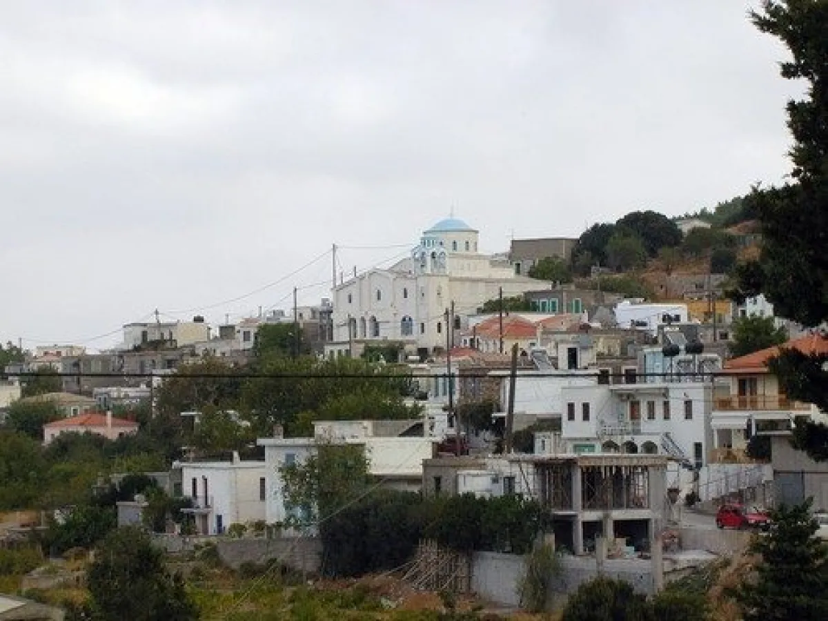
Kallithea is a small mountain village in western Samos, built on the northwestern foothills of Kerkis, in one of the most remote and authentic areas of the island. It is the westernmost village of Samos and lies at an elevation of approximately 300 metres, with an open horizon towards the Aegean Sea, Fournoi and Ikaria.
The village retains a peaceful agricultural character, with narrow lanes, old houses, small courtyards and a strong presence of stone in its traditional architecture. The name “Kallithea”, meaning beautiful view, perfectly suits its location, as the western panorama and especially the summer sunset are among the most characteristic features of the area.
Behind the settlement rises the mountain massif of Kerkis, with old paths, hermitages, caves and isolated chapels, while lower down dirt roads lead towards Agios Isidoros and the historic centre of Samian wooden shipbuilding. In this way, Kallithea brings together within a relatively small geographical area a traditional village, mountain landscapes, monastic heritage and the wild western coast of Samos.
📍 Location and geographical character
Kallithea is located on the western side of Samos, on the northwestern foothills of Kerkis.
The village is built at an elevation of approximately 300 metres and its position offers panoramic views towards the western Aegean Sea.
The landscape around Kallithea is characterised by:
✅ Olive groves
✅ Rocky slopes
✅ Mediterranean shrub vegetation
✅ Kermes oak
✅ Pine trees
✅ Cypress trees
✅ Small cultivated areas
✅ Stone terraces
✅ Agricultural roads
✅ Steep slopes of Kerkis
The landscape becomes increasingly rugged as one approaches the western and northwestern coastline.
🏛️ Administrative identity
Kallithea today forms a separate Municipal Community and belongs to:
✅ The Municipal Community of Kallithea
✅ The Municipal Unit of Marathokampos
✅ The Municipality of Western Samos
✅ The Regional Unit of Samos
✅ The North Aegean Region
The Municipal Community of Kallithea officially consists of the settlement of Kallithea.
Despite its small population, the village retains its own administrative identity and continues to function as a local centre for the wider agricultural area.
📜 From Prinias to Kalampaktasi and Kallithea
In older local tradition, the village is mentioned by the name Prinias, associated with the abundance of kermes oaks and evergreen oaks that once covered the area.
This vegetation had particular economic importance, as it was used for firewood and for charcoal production, an activity that for many decades supplemented the income of local residents.
During the period of the Principality of Samos, Kallithea and neighbouring Drakei were administratively connected within the Municipality of Kalampaktasi.
In official administrative records from the early 20th century, the settlement appears under the name Kalampaktasi.
The name is associated with the period of Ottoman influence and with the strategic observation position offered by the western side of Kerkis over the sea passage between Samos, Ikaria and Fournoi.
The present name Kallithea was officially established in 1950 and refers to the exceptional views offered by the village.
📜 Administrative development
The Community of Kalampaktasi was officially established in 1918 with Kalampaktasi as its administrative seat.
The administrative history of the area includes:
✅ 1918: Establishment of the Community of Kalampaktasi with the settlement of the same name as its seat
✅ 1920: Recognition of Agios Isidoros and its incorporation into the Community of Kalampaktasi
✅ 1928: Recognition of Plaka and its incorporation into the community
✅ 1940: Agios Isidoros and Plaka cease to be recorded as separate official settlements of the community
✅ 1950: Kalampaktasi is officially renamed Kallithea and the community becomes the Community of Kallithea
✅ 1997: Under the “Kapodistrias” reform, Kallithea becomes part of the Municipality of Marathokampos
✅ 2010: Under the “Kallikratis” programme, it becomes part of the unified Municipality of Samos
✅ 2019: Following the division of the Municipality of Samos, it becomes part of the Municipality of Western Samos
👥 Population and demographic development
Kallithea had a much larger population during the 19th and first half of the 20th century.
Historical and more recent censuses record:
✅ 1886: 419 residents
✅ 1928: 635 residents
✅ 1961: 472 residents
✅ 1981: 284 residents
✅ 1991: 220 residents
✅ 2001: 204 residents
✅ 2011: 140 residents
✅ 2021: 146 residents
The significant decline after the middle of the 20th century followed the broader pattern of migration from remote villages of western Samos.
The 2021 census shows a small population increase compared with the previous decade.
🏘️ The form of the village
Kallithea retains the form of a small mountain village of Samos.
The houses have developed along a slope, with roads that follow the natural contours of the land.
Characteristic elements include:
✅ Narrow lanes
✅ Paved sections
✅ Old two-storey houses
✅ Stone masonry
✅ Tiled roofs
✅ Small balconies
✅ Courtyards with flowers
✅ Stone walls
✅ Olive and fruit trees among the houses
Limited modern construction has helped the village preserve its peaceful and authentic appearance.
🌅 The view and the sunset
Kallithea is particularly well known for its sunset.
From many points in the village, the horizon opens towards the western Aegean Sea and, on clear days, the surrounding island groups can be seen.
The view includes:
✅ Ikaria
✅ Fournoi
✅ Open Aegean Sea
✅ Western slopes of Kerkis
✅ Rugged coastline
✅ Summer sunset
During the afternoon, the western light illuminates the houses and mountain slopes, creating one of the most characteristic photographic landscapes of western Samos.
⛪ Agios Georgios
The central parish church of Kallithea is Agios Georgios.
The history of the present parish church is connected with the final years of the Principality of Samos and the development of the village during the 19th century.
Its construction was organised with the participation of the local community, at a time when Kallithea had several hundred residents and significant agricultural and forestry activity.
The church remains one of the main landmarks within the village today.
🌿 Kerkis and the natural environment
Behind Kallithea rises Kerkis, also known as Kerketeas, the largest mountain massif of western Samos.
The summit of Vigla reaches approximately 1,433 metres and dominates the entire area.
The western slopes are characterised by:
✅ Limestone formations
✅ Steep cliffs
✅ Caves
✅ Pine trees
✅ Kermes oaks and oak trees
✅ Low Mediterranean vegetation
✅ Seasonal wildflowers
✅ Old paths
✅ Natural wildlife refuges
Birds of prey and other species of the mountain fauna of Samos can also be observed in the area.
🕯️ The hermitages of Kerkis
On the higher slopes above Kallithea lies the area known as Askitiria, or the Hermitages.
The name is connected with the long monastic and ascetic tradition of Kerkis.
In the wider area there are:
✅ Small chapels
✅ Natural caves
✅ Rocky shelters
✅ Old ascetic sites
✅ Paths following the mountain slopes
✅ Locations with panoramic views
The isolated character of Kerkis and its many natural cavities created suitable conditions for hermit and monastic life from Byzantine times.
⛪ Panagia Makrini
One of the most important religious and nature-related landmarks of the area is Panagia Makrini.
The small chapel is built inside a natural cave on the western side of Kerkis, at an elevation of approximately 823 metres.
The structure makes use of the natural rock cavity, creating a distinctive setting in which the cave itself forms an essential part of the church.
Panagia Makrini is dedicated to the Dormition of the Virgin Mary and celebrates on 15 August.
Access is on foot and the route requires good physical condition, appropriate footwear, sufficient water and caution on the steeper sections.
⛪ Agia Aikaterini
Along the mountain route towards the higher areas of Kerkis lies the chapel of Agia Aikaterini.
It is one of the religious landmarks associated with the old paths and ascetic tradition of the area.
The route towards Panagia Makrini passes through the wider area of Agia Aikaterini before continuing towards the more demanding mountain section.
🥾 Hiking on western Kerkis
Kallithea is one of the important starting points for exploring the western side of Kerkis.
Routes can lead:
✅ Towards Panagia Makrini
✅ Towards Agia Aikaterini
✅ To the Askitiria area
✅ Along old agricultural paths
✅ To higher slopes of Kerkis
✅ Towards isolated western coastal areas
✅ To viewpoints overlooking Ikaria and Fournoi
The mountain routes vary in difficulty and several require experience, suitable equipment and sufficient water.
During the summer months, the morning hours are more suitable because of the heat.
🫒 Agriculture and olive cultivation
The economy of Kallithea was historically based on the use of the land and the natural resources of Kerkis.
Important activities included and continue to include:
✅ Olive cultivation
✅ Small-scale livestock farming
✅ Vegetable growing
✅ Small vineyards
✅ Beekeeping
✅ Family agricultural production
Olive cultivation is the most important agricultural activity of the area, and olive groves cover a large part of the lower slopes around the village.
🔥 Historic charcoal production
The forest vegetation around Kallithea provided an important economic resource for local residents.
For many years, charcoal production developed using mainly kermes oak and other woody plants of the area.
The activity required:
✅ Cutting timber
✅ Collecting and transporting wood
✅ Constructing traditional charcoal kilns
✅ Monitoring the burning process for several days
✅ Transporting the finished charcoal to other areas
Today this activity has virtually disappeared, but it remains an important part of the economic history of the village.
⚓ The connection with Agios Isidoros
Below the western slopes lies the isolated bay of Agios Isidoros, also locally known as Ai Sideris.
For many decades, it served as an outlet to the sea for Kallithea and Drakei.
Before the completion of the modern road network, sea transport was particularly important for moving:
✅ People
✅ Agricultural products
✅ Timber
✅ Supplies
✅ Newly built wooden vessels
The area of Agios Isidoros remains one of the most isolated and distinctive coastal areas of western Samos.
🪵 The traditional shipyard of Agios Isidoros
Agios Isidoros is closely connected with the history of traditional wooden shipbuilding on Samos.
During the 20th century, several small shipbuilding and repair yards operated there, employing residents from Kallithea, Drakei and other areas.
The shipyards constructed:
✅ Trechantiri boats
✅ Small boats
✅ Fishing trawlers
✅ Perama vessels
✅ Varkalades
✅ Traditional wooden hulls
✅ Wooden cargo boats
Construction relied on local timber and the skills of Samian shipwrights.
The historic shipyard of Agios Isidoros has been designated a protected historic site and is one of the most important surviving locations of the traditional shipbuilding heritage of Samos.
🌊 The wild western coast
The western coastline below Kallithea is very different from the more developed tourist areas along the southern coast of Marathokampos.
It is characterised by:
✅ Small isolated bays
✅ Rocky shores
✅ Pebble beaches
✅ Deep clear water
✅ Steep slopes
✅ Very limited development
✅ Very little tourist activity
In addition to Agios Isidoros, the wider area includes isolated coastal locations such as Varsamo, which are reached by agricultural or dirt roads and require greater caution.
🏘️ The connection with Drakei
Drakei lies approximately 6 kilometres to the north and is the village with which Kallithea has the closest historical relationship.
The two villages:
✅ Together formed the Municipality of Kalampaktasi
✅ Shared agricultural and forestry activities
✅ Were connected with the shipbuilding tradition of Agios Isidoros
✅ Used common routes towards the western coast
✅ Developed similar economic and social characteristics
The Kallithea–Drakei route is one of the most distinctive road journeys in western Samos, with continuous views towards the mountain and the Aegean Sea.
🎉 Local life and tradition
Daily life in Kallithea remains organised around the small community, the church, agricultural activities and the social bonds of its residents.
During summer, the population increases as people originating from the village return from other parts of Greece or from abroad.
Religious festivals, local gatherings and family events continue to form an important part of community life.
🛏️ Infrastructure and everyday services
Kallithea remains a small village with limited commercial activity.
Basic local services are available in the area, while for larger shopping needs, banking services, pharmacies and a wider choice of dining or accommodation, visitors travel to larger settlements of the Municipal Unit of Marathokampos or to Karlovasi.
Its remote location is part of the character of the village and should be taken into account before longer hiking or coastal excursions.
📸 Photography and views
Kallithea offers particularly rich photographic interest.
Highlights include:
✅ Traditional houses
✅ Narrow lanes
✅ The Church of Agios Georgios
✅ Olive groves
✅ The slopes of Kerkis
✅ Views towards Ikaria and Fournoi
✅ The western Aegean Sea
✅ Old agricultural paths
✅ The road towards Drakei
✅ The summer sunset
The afternoon is the best time for photography, as the sun sets opposite the village and illuminates the entire western side of Kerkis.
🌿 What to see
During a visit to the Municipal Community of Kallithea, it is worth seeing:
✅ The traditional village
✅ Old houses and lanes
✅ The Church of Agios Georgios
✅ Panoramic viewpoints
✅ The sunset
✅ Olive groves and stone terraces
✅ Old paths of Kerkis
✅ The Askitiria area
✅ Agia Aikaterini
✅ Panagia Makrini
✅ Nearby Drakei
✅ The bay of Agios Isidoros
✅ The historic shipyard of Agios Isidoros
✅ The isolated western coastal areas
🚗 Suggested routes
Kallithea can serve as a base for several interesting excursions:
✅ Marathokampos – Kallithea: A road journey towards the westernmost village of Samos.
✅ Kallithea – Drakei: A short route connecting the two historic villages of the western side.
✅ Kallithea – Agios Isidoros: A descent towards the isolated coast and historic shipyard.
✅ Kallithea – Panagia Makrini: A mountain hiking route with religious and natural interest.
✅ Kallithea – Askitiria of Kerkis: Exploration of the mountain’s ascetic tradition.
✅ Kallithea – Drakei – Agios Isidoros: A combination of villages, mountain scenery, maritime history and wild coastline.
🚶 Visitor experience
Approximately one hour is sufficient for a basic exploration of the village.
With time for photography and watching the sunset, the visit can easily be extended to two or three hours.
Combined with Drakei or Agios Isidoros, it is worth allowing half a day.
The hike towards Panagia Makrini and the higher slopes of Kerkis requires separate time and preparation and can turn the visit into a full-day excursion.
📆 When to visit
Spring: An excellent period for hiking, wildflowers, green landscapes and photography.
Summer: Ideal for an afternoon visit and watching the famous sunset.
15 August: Feast day of Panagia Makrini and an important date for the religious tradition of the area.
Autumn: A good period for peaceful exploration, agricultural landscapes and hiking.
Winter: A very quiet period, with more intense greenery but also a greater possibility of rain and fog on the higher slopes.
Morning: Suitable for mountain hiking.
Afternoon: The best time for exploring the village and photographing the sunset.
🧭 How to get there
Kallithea is reached by paved roads through the Municipal Unit of Marathokampos.
The route is mountainous with several bends, but is accessible with a standard car.
Indicative road distances:
✅ Approximately 22–24 kilometres from Marathokampos
✅ Approximately 35–37 kilometres from Karlovasi
✅ Approximately 6 kilometres from Drakei
✅ Approximately 50 kilometres from the airport
✅ Approximately 63–64 kilometres from the town of Samos
For Agios Isidoros and other isolated coastal areas, the route continues on dirt roads and requires greater caution.
ℹ️ Useful information
✅ Official name: Kallithea
✅ Administrative name: Municipal Community of Kallithea
✅ Geographical category: Community
✅ Character: Traditional mountain and agricultural village
✅ Location: Western Samos
✅ Distinctive geographical feature: Westernmost village of Samos
✅ Mountain massif: Kerkis – Kerketeas
✅ Village elevation: Approximately 300 metres
✅ Older local name: Prinias
✅ Former official name: Kalampaktasi
✅ Official renaming to Kallithea: 9 February 1950
✅ Municipal Unit: Marathokampos
✅ Municipality: Western Samos
✅ Regional Unit: Samos
✅ Region: North Aegean
✅ Population in 2011: 140 residents
✅ Population in 2021: 146 residents
✅ Parish church: Agios Georgios
✅ Main traditional activity: Olive cultivation
✅ Historic activities: Livestock farming, logging and charcoal production
✅ Important religious landmark: Panagia Makrini
✅ Elevation of Panagia Makrini: Approximately 823 metres
✅ Mountain area of interest: Askitiria of Kerkis
✅ Nearby historic village: Drakei
✅ Coastal point of interest: Agios Isidoros
✅ Important cultural landmark: Traditional Shipyard of Agios Isidoros
✅ Characteristic view: Ikaria, Fournoi and the western Aegean Sea
✅ Ideal visiting time: Afternoon and sunset
✅ Recommended time in the village: 1–3 hours
✅ Recommended time including surrounding routes: Half a day to a full day
✅ Suitable for: Traditional village exploration, photography, sunset views, hiking, religious interest, nature exploration and discovering western Samos


Add new comment