
Agios Panteleimon of Lekka

🏞️ Agios Panteleimon of Lekka, Samos – The Small Settlement in the Natural Landscape of Kerkis
Agios Panteleimon is one of the smallest officially recognised settlements of western Samos, located in a green area southwest of Karlovasi and close to Lekka. Built at a low elevation among steep slopes, streams and dense vegetation, it retains a peaceful agricultural character and the atmosphere of an old Samian neighbourhood that developed away from modern tourism.
The history of the settlement goes back well before its official administrative recognition in 1918. For many decades it was known as Tsourlaioi, while its present name is associated with the Church of Agios Panteleimon, which remains the main religious landmark of the area.
Its location between Lekka, Karlovasi and the natural zone extending towards Potami makes it an interesting stop for visitors wishing to discover a less prominent side of western Samos, characterised by flowing water, old houses, cultivated land and easy access to important natural attractions.
📍 Location and natural environment
Agios Panteleimon is located in the northwestern part of Samos, southwest of Karlovasi and approximately 1.5 kilometres northwest of Lekka.
The settlement lies at an average elevation of approximately 108 metres, within a natural depression surrounded by slopes and low mountains.
The area is characterised by the strong presence of water and rich vegetation. Streams descending from the surrounding slopes feed the wider drainage zone of Potami, creating an environment quite different from the drier areas of western Samos.
Around the settlement, visitors can find:
✅ Olive groves
✅ Fruit trees
✅ Small family cultivation plots
✅ Plane trees and moisture-loving vegetation
✅ Pine trees and Mediterranean shrubs
✅ Streams and natural springs
✅ Steep rocky slopes
🏛️ Administrative identity
Agios Panteleimon belongs to:
✅ The Municipal Community of Lekka
✅ The Municipal Unit of Karlovasi
✅ The Municipality of Western Samos
✅ The Regional Unit of Samos
✅ The North Aegean Region
Together with Lekka, the settlement forms the present residential composition of the Municipal Community of Lekka.
Its administrative connection with Lekka has deep historical roots, as it was already incorporated into the Community of Lekka under its former name when the community was officially established in 1918.
📜 Historical development of the settlement
Agios Panteleimon was officially recognised as a settlement on 21 September 1918 under the name Tsourlaioi and was incorporated into the then Community of Lekka.
The area was already inhabited before its official administrative recognition. Historical records from the 19th century describe a small but organised agricultural settlement, with houses and a population relying mainly on the cultivation of the surrounding land.
During the first decades of the 20th century, the settlement had a significantly larger population than today, reflecting the stronger agricultural activity of the area at that time.
On 4 October 1940, the name Tsourlaioi was officially replaced by Agios Panteleimon.
📝 The former name Tsourlaioi
The area was formerly known as Tsourlaioi or Sourlaioi.
Local tradition connects the name with the surname Sourlis and with one of the early residents of the area.
The old place name continues to survive in local everyday usage and can still be found in references to roads and locations in western Samos.
The present name comes from Agios Panteleimon and the church dedicated to him within the settlement.
🏛️ Administrative changes
The administrative history of the settlement followed the major reforms of local government:
✅ 1918: Recognised as Tsourlaioi and incorporated into the Community of Lekka.
✅ 1940: Officially renamed Agios Panteleimon.
✅ 1997: Under the “Kapodistrias” administrative reform, incorporated into the Municipality of Karlovasi.
✅ 2010: Under the “Kallikratis” programme, incorporated into the unified Municipality of Samos.
✅ 2019: Following the division of the Municipality of Samos, incorporated into the new Municipality of Western Samos.
👥 Population and demographic development
Agios Panteleimon had a considerably larger population in the past than it does today.
Selected census figures record:
✅ 1920: 84 residents
✅ 1928: 104 residents
✅ 1940: 89 residents
✅ 1951: 56 residents
✅ 1961: 54 residents
✅ 1981: 32 residents
✅ 1991: 26 residents
✅ 2001: 18 residents
✅ 2011: 7 residents
✅ 2021: 12 permanent residents
The long-term population decline followed the broader demographic changes experienced by many small agricultural settlements of Samos, as employment opportunities and everyday services became increasingly concentrated in the island’s larger urban centres.
Despite its very small permanent population, several houses remain in use and the area becomes livelier during the summer months and on local feast days.
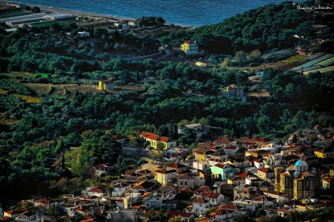
🏘️ The form of the settlement
Agios Panteleimon does not have a dense urban layout or an organised commercial centre.
The houses are relatively few and are arranged close to the road and along small local routes that follow the natural relief.
The settlement includes:
✅ Old stone-built houses
✅ Tiled roofs
✅ Small courtyards and gardens
✅ Stone walls and terraces
✅ More recent rural houses
✅ Abandoned or ruined older buildings
✅ Cultivated land between the houses
The low building density allows natural vegetation to remain one of the dominant elements of the landscape.
⛪ The Church of Agios Panteleimon
The Church of Agios Panteleimon is the main religious landmark of the settlement and is directly connected with its present name.
The church stands within the natural surroundings of the small community and remains an important point of reference for residents of Lekka and the wider Karlovasi area.
The feast day of Agios Panteleimon is celebrated on 27 July.
The celebration attracts residents and visitors and is one of the periods when the small settlement becomes noticeably livelier.
💧 Water, streams and vegetation
The presence of water is one of the most characteristic features of the area.
The surrounding slopes collect rainwater and feed small streams, while the shape of the terrain creates more humid areas with dense vegetation.
The natural moisture favours:
✅ Plane trees
✅ Ferns
✅ Mosses
✅ Brambles
✅ Wild plants
✅ Fruit trees
✅ Dense streamside vegetation
The area is especially green during spring, when the streams carry more water and vegetation reaches its most vigorous stage of growth.
🌿 Agricultural landscape and traditional cultivation
The economy of the small settlement was historically connected with agriculture and the use of the fertile land around the streams.
Crops traditionally grown in the area included:
✅ Olives
✅ Fruit trees
✅ Pomegranates
✅ Vegetables
✅ Grapevines
✅ Small family cultivation plots
The pomegranates of the area are mentioned in local tradition for their size and flavour.
Today agricultural activity is more limited than in the past, but olive groves, old terraces, gardens and fruit trees continue to define the landscape.
🌳 The connection with Lekka
Lekka lies approximately 1.5 kilometres southeast and is the larger settlement with which Agios Panteleimon has the closest historical connection.
The two settlements have shared an administrative history since 1918 and today form the Municipal Community of Lekka.
Their short distance allows visitors to combine a visit to Agios Panteleimon with an exploration of Lekka, which has a larger traditional residential centre and more everyday activity.
The route between the two settlements passes through agricultural and natural landscapes on the northeastern foothills of Kerkis.
🏙️ The connection with Karlovasi
Karlovasi is the nearest major urban centre and provides most of the everyday services needed by local residents.
There visitors can find:
✅ Public services
✅ Shops and supermarkets
✅ Pharmacies
✅ Banks
✅ Health Centre
✅ Educational facilities
✅ Restaurants and cafés
✅ Harbour and transport infrastructure
The short distance from Karlovasi allows Agios Panteleimon to retain the tranquillity of a very small agricultural settlement without being isolated from the main services of western Samos.
🏞️ Potami Waterfalls
The well-known Potami Waterfalls are located within the wider natural zone northwest of the settlement and are among the most important natural attractions of western Samos.
Water flows through a deep, green ravine and forms small waterfalls and natural pools between the rocks.
The area is characterised by:
✅ Plane trees
✅ Dense streamside vegetation
✅ Rocks and narrow passages
✅ Flowing water
✅ Small natural pools
✅ A cool microclimate
The volume of water is greater after the winter rains and during spring, while in summer the route is a popular choice because of the shade and cooler temperatures.
🥾 The route towards Potami
The area of Agios Panteleimon lies within the broader network of agricultural roads and paths linking Lekka, the western slopes and the Potami area.
The routes pass through:
✅ Olive groves
✅ Old terraces
✅ Streams
✅ Pine and plane trees
✅ Agricultural land
✅ Viewpoints towards Karlovasi and the northern coast
The terrain and vegetation can make some of the smaller paths more difficult, particularly after rainfall.
For walking or hiking, sturdy footwear, drinking water and caution on wet stones or steeper sections are recommended.
🏖️ Potami Beach
Potami Beach lies northwest of the settlement, near Karlovasi, and is one of the best-known beaches of western Samos.
The coast is mainly pebbled, with clear, deep water and an open horizon towards the northern Aegean Sea.
Its northern orientation makes it more exposed to wind and waves, especially on days when the meltemi is strong.
Combining Agios Panteleimon, the waterfalls and Potami Beach creates an interesting route connecting agricultural countryside, forest, flowing water and the sea.
📸 Photography and natural landscape
The small number of houses and the strong presence of vegetation create a particularly peaceful setting for photography.
Interesting subjects include:
✅ The Church of Agios Panteleimon
✅ Old houses and stone walls
✅ Streams and streamside vegetation
✅ Olive groves and traditional cultivated land
✅ Small rural routes
✅ The natural landscape towards Potami
✅ The waterfalls and natural pools
✅ Potami Beach
Spring offers the greenest scenery, while afternoon light highlights the slopes and older houses.
🌿 What to see
During a visit to Agios Panteleimon, look for:
✅ The small historic settlement
✅ The Church of Agios Panteleimon
✅ The old houses and rural courtyards
✅ The stone terraces
✅ The streams and rich vegetation
✅ The olive groves and fruit trees
✅ The peaceful local routes
✅ Nearby Lekka
✅ Potami Waterfalls
✅ The natural ravine of Potami
✅ Potami Beach
✅ The northern coastline near Karlovasi
🚗 Suggested routes
The area is suitable for combined short excursions:
✅ Karlovasi – Agios Panteleimon: A short route from the urban centre into the peaceful Samian countryside.
✅ Lekka – Agios Panteleimon: Exploration of the two settlements belonging to the same community.
✅ Agios Panteleimon – Potami area: A route focusing on the natural landscape and streams.
✅ Agios Panteleimon – Potami Waterfalls: A combination of a small agricultural settlement and a natural attraction.
✅ Agios Panteleimon – Potami Beach: A route from the interior of western Samos to the northern coast.
✅ Lekka – Agios Panteleimon – Potami – Karlovasi: A complete route for half a day or a full day.
🚶 Visitor experience
Agios Panteleimon is a destination for peaceful exploration rather than intensive tourist activity.
Approximately thirty minutes to one hour is sufficient for a basic walk through the small settlement.
The visit becomes more interesting when combined with Lekka, Potami Waterfalls or Potami Beach.
The natural surroundings, old houses, church and limited traffic create an atmosphere very different from the larger settlements and tourist resorts of Samos.
📆 When to visit
Spring: The best season for lush vegetation, flowing water, photography and walking.
Summer: A suitable period for combining the settlement with the waterfalls and Potami Beach.
27 July: The feast day of Agios Panteleimon and an important date in the settlement’s annual religious calendar.
Autumn: A good period for peaceful rural routes and exploring the surrounding area.
Winter: The streams carry more water, but humidity and rainfall require additional care on small roads and paths.
Morning: Ideal for walking and photography among the vegetation.
Afternoon: Suitable for a relaxed visit to the settlement and nearby Lekka.
🧭 How to get there
Access to Agios Panteleimon is provided through the local road network of western Samos, via the areas of Lekka and Karlovasi.
The settlement is located approximately:
✅ 1.5 kilometres northwest of Lekka
✅ Southwest of Karlovasi
✅ Approximately 36 kilometres west of the town of Samos
The settlement is accessible by a standard car, although the local roads are narrower than the main road network and in some places follow the steep relief of the area.
Limited traffic makes exploration easier, but care is required when vehicles meet on narrow sections and after heavy rainfall.
ℹ️ Useful information
✅ Official name: Agios Panteleimon
✅ Former name: Tsourlaioi
✅ Geographical category: Settlement
✅ Character: Small agricultural and nature-oriented settlement
✅ Location: Northwestern Samos
✅ Municipal Community: Lekka
✅ Municipal Unit: Karlovasi
✅ Municipality: Western Samos
✅ Regional Unit: Samos
✅ Region: North Aegean
✅ Official recognition: 21 September 1918
✅ Official renaming: 4 October 1940
✅ Population in 2011: 7 permanent residents
✅ Population in 2021: 12 permanent residents
✅ Elevation: Approximately 108 metres
✅ Distance from Lekka: Approximately 1.5 kilometres
✅ Main religious landmark: Church of Agios Panteleimon
✅ Feast day: 27 July
✅ Nearby natural attraction: Potami Waterfalls
✅ Nearby beach: Potami
✅ Main landscape features: Streams, olive groves, fruit trees, dense vegetation and rocky slopes
✅ Recommended time in the settlement: 30 minutes–1 hour
✅ Recommended time including the surrounding area: Half a day to a full day
✅ Suitable for: Nature exploration, photography, gentle walking, religious interest and discovering small settlements



Add new comment