
Agios Konstantinos of Samos
🌊 Municipal Community of Agios Konstantinos, Samos – From Ano Agios to the Northern Coast
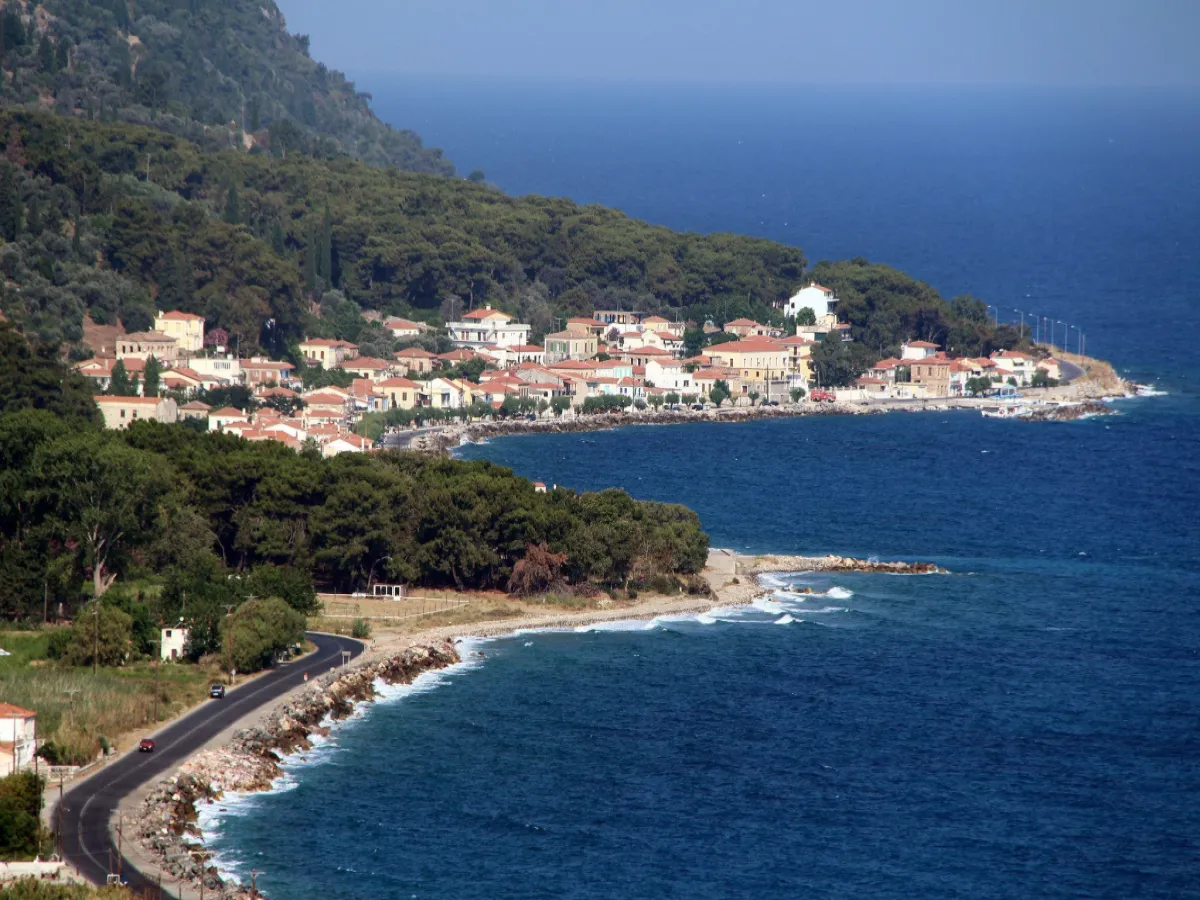
The Municipal Community of Agios Konstantinos is located in northern Samos, between the town of Samos and Karlovasi, in one of the greenest areas of the island. Today’s settlement extends from the coastline of the northern Aegean Sea to the lower slopes of Mount Ampelos–Karvounis, combining seaside life, traditional architecture, vineyards, olive groves, flowing water and dense vegetation.
Agios Konstantinos has two characteristic areas. The coastal zone, which historically developed as Ormos Agiou Konstantinou or Kato Agios Konstantinos, stretches for about one kilometre along the shoreline, while slightly higher lies Ano Agios Konstantinos, the older core of the village. Although today they form a single official settlement, the two areas still retain a different appearance and atmosphere.
The community also includes the historic settlement of Valeontades, within the lush Aidonia valley. The areas of Platanakia, Aidonia and Kakorema, the old paths leading towards the mountain villages and the close relationship with viticulture give the area a distinctive character that connects the sea with the mountainous natural environment of northern Samos.
📍 Location and geographical character
Agios Konstantinos is located on the northern coast of Samos, approximately 20 kilometres west of the town of Samos and about 12 kilometres east of Karlovasi.
The coastal centre lies almost at sea level, at an elevation of around 10 metres, while the settlement gradually rises towards the slopes of Karvounis.
The morphology of the area creates a distinctive combination of:
✅ Northern coastline
✅ Dense vegetation
✅ Terraced vineyards
✅ Olive groves and orchards
✅ Streams and springs
✅ Plane-tree groves
✅ Forested slopes
✅ Small valleys and ravines
The strong presence of water makes the landscape noticeably different from many drier parts of the island.
🏛️ Administrative identity of the community
The Municipal Community of Agios Konstantinos belongs to:
✅ The Municipal Unit of Vathy
✅ The Municipality of Eastern Samos
✅ The Regional Unit of Samos
✅ The North Aegean Region
The community includes two officially recognised settlements:
✅ Agios Konstantinos
✅ Valeontades
Agios Konstantinos is the main and most populated settlement and the administrative centre of the community.
🗺️ Coastal and Ano Agios Konstantinos
Today’s Agios Konstantinos develops across two main geographical zones.
✅ Coastal Agios Konstantinos: Extends along the northern coast and forms today’s main residential and commercial centre. Historically it was known as Ormos Agiou Konstantinou or Kato Agios Konstantinos.
✅ Ano Agios Konstantinos: The older core of the village, built higher among the vegetation, with older houses, small roads, traditional courtyards and historic churches.
The two areas lie very close to each other and today form one officially recognised settlement.
📜 Origins and historical development
The exact date of the foundation of Agios Konstantinos is unknown, although its organised development is placed in the 18th century.
The wider area of north-central Samos had Vourliotes as one of its most important older settlement centres. As the population increased, residents gradually established themselves in new locations on the surrounding slopes and valleys.
The older settlement core developed in the area of present-day Ano Agios Konstantinos.
During the 19th century, the coastal zone also began to develop. Ormos initially functioned mainly as the port of the higher settlement, with storage and wine-related facilities close to the sea.
The ability to load and transport wine from the coast contributed significantly to the gradual growth of the seaside part of the village.
🏛️ The Six Neighbourhoods
During the period of the Principality of Samos, Agios Konstantinos was closely connected with the historic group of settlements known as the “Six Neighbourhoods”.
This group included:
✅ Agios Konstantinos
✅ Nenedes – present-day Ampelos
✅ Stavrinides
✅ Manolates
✅ Margarites
✅ Valeontades
These settlements shared close social, economic and administrative relations, while agriculture and especially wine production formed the main economic activity of the area.
Agios Konstantinos acquired an important role within this settlement network, particularly because of its access to the sea and the development of Ormos.
📜 Administrative development
The Community of Agios Konstantinos was officially established on 21 September 1918.
At the time of its establishment, its administrative seat was Ormos Agiou Konstantinou and it included several settlements of the surrounding area.
Its administrative development included several important changes:
✅ 1918: Establishment of the Community of Agios Konstantinos
✅ 1919: Stavrinides separates and forms an independent community
✅ 1928: Ormos Agiou Konstantinou ceases to be recorded as a separate settlement
✅ 1940: Ano Agios Konstantinos is officially recognised
✅ 1971: Ano Agios Konstantinos ceases to be a separate settlement and is incorporated into Agios Konstantinos
✅ 1997: Under the “Kapodistrias” reform, the area is incorporated into the Municipality of Vathy
✅ 2010: Under the “Kallikratis” programme, it becomes part of the unified Municipality of Samos
✅ 2019: Following the division of the Municipality of Samos, it becomes part of the Municipality of Eastern Samos
👥 Population and demographic development
The population history of Agios Konstantinos reflects both the economic growth associated with viticulture and the migration trends of the 20th century.
Historical and more recent records mention:
✅ 1828: 254 residents
✅ 1869: 364 residents
✅ 1886: 553 residents
✅ 1928: 809 residents
✅ 1961: 496 residents
✅ 1981: 360 residents
✅ 1991: 406 residents
✅ 2001: 394 residents
✅ 2011: approximately 400 residents in the wider community area
✅ 2021: 331 residents
The strong population increase in the early 20th century was connected with wine production and trade, the development of the coastal settlement and the arrival of new residents.
During the 1920s, refugees from Asia Minor were also added to the population.
After the Second World War, migration towards Athens, the United States, Australia and other areas led to a gradual decline in population.
🍇 Viticulture and wine
Viticulture was for centuries the main pillar of the economy of Agios Konstantinos.
The slopes above the settlement were shaped with stone terraces, allowing cultivation even on steep ground.
In 1828, wine production of approximately 8,000 “gomaria” was recorded.
The “gomari” was a practical unit of load measurement, corresponding approximately to the amount that could be carried by a pack animal.
The large volume of wine production also explains the development of warehouses in the coastal Ormos, from where the product could be transported more easily by sea.
The cultivation of the White Muscat grape remains a characteristic feature of the agricultural landscape of the area.
🌿 Agriculture and local production
In addition to viticulture, important activities included and continue to include:
✅ Olive cultivation
✅ Fruit growing
✅ Vegetable cultivation
✅ Grape production
✅ Beekeeping
✅ Small-scale family farming
Historically, the wider area also produced:
✅ Chestnuts
✅ Walnuts
✅ Potatoes
✅ Honey
✅ Timber
✅ Souma and other local spirits
Agricultural activity has declined compared with the 19th and early 20th centuries, but vineyards, olive groves and cultivated terraces remain defining features of the landscape.
📜 Professions and social life in the early 20th century
The electoral register of 1914 presents a society with considerable professional diversity.
Among the recorded occupations were:
✅ 61 farmers
✅ 16 sailors
✅ 10 merchants
✅ 4 coffeehouse keepers
✅ 3 grocers
✅ 2 butchers
✅ Carpenters
✅ Chair makers
✅ Coopers
✅ Blacksmiths
✅ Millers
✅ One caulker – ship carpenter
✅ Teachers
✅ A doctor
✅ Priests
✅ Gendarmes and other public officials
The presence of sailors, merchants, coopers and a ship carpenter reflects the close relationship of the village with the sea and the transport of agricultural products.
Women, although often recorded in older official documents mainly as engaged in “household work”, actively participated in agricultural tasks and family production.
🏘️ Ano Agios Konstantinos
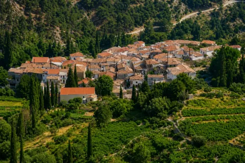
Ano Agios Konstantinos forms the most historic core of the present-day village.
Unlike the linear development of the coastal zone, the houses here are set among vegetation and follow the natural contours of the land.
Characteristic elements include:
✅ Traditional houses
✅ Tiled roofs
✅ Stone-built ground floors
✅ Small courtyards
✅ Narrow streets
✅ Stone walls
✅ Gardens and fruit trees
✅ Cypress and olive trees
Limited modern construction has allowed Ano Agios to preserve more of the appearance of an old Samian settlement.
⛪ Church of Saints Constantine and Helen
The historic Church of Saints Constantine and Helen in Ano Agios Konstantinos is directly connected with the name and development of the village.
The tradition of the settlement is closely linked with the old ecclesiastical dependency of the area, while the church is one of the most important historical and religious landmarks of the village.
Its present form and long-standing presence reflect the religious continuity of the old settlement core.
The feast of Saints Constantine and Helen is celebrated on 21 May.
⛪ The Church of Panagia in Ano Agios Konstantinos
Another important religious landmark of Ano Agios is the Church of Panagia.
The church is associated with the celebration of the Dormition of the Virgin Mary on 15 August and remains an important point of reference for residents and people originating from the village.
The area around the church retains the peaceful atmosphere of the old settlement, among olive trees, cypresses and traditional homes.
🌊 Coastal Agios Konstantinos
The coastal zone is today the liveliest part of the village.
It develops linearly between the main road and the sea, with houses, small businesses, food establishments and tourist facilities.
The coast is mainly characterised by:
✅ Pebbles
✅ Clear water
✅ Small coves
✅ Rocky sections
✅ Small piers and boats
✅ Open views towards the northern Aegean Sea
The old role of Ormos in storing and transporting wine has today been replaced by a more residential and tourism-oriented character.
🏖️ Beach and sea
Along Agios Konstantinos there are several small sections of coastline used for swimming.
The shoreline is mainly pebbled and the water becomes deep relatively quickly.
Its northern orientation means that the area is directly affected by the meltemi.
On calm days, the sea is clear and suitable for swimming, while strong northerly winds can create considerable waves.
Morning hours are often better for calmer sea conditions.
💧 Kakorema and flowing water
One of the most important natural features of the area is Kakorema, the stream descending from the slopes of Karvounis.
The presence of water supports a particularly rich ecosystem with:
✅ Plane trees
✅ Ferns
✅ Mosses
✅ Dense streamside vegetation
✅ Fruit trees
✅ Wild plants
✅ Rich birdlife
Kakorema crosses the green areas east and southeast of the village and is naturally connected with Platanakia and the Aidonia valley.
🌳 Platanakia
Platanakia lies east of Agios Konstantinos and is one of the best-known green areas of Samos.
The landscape is characterised by large plane trees, abundant water, shade and lower temperatures compared with the coastal zone.
The natural environment includes:
✅ Tall plane trees
✅ Flowing water
✅ Small bridges and crossings
✅ Dense vegetation
✅ Shaded areas
✅ Walking paths
✅ Rich birdlife
The area forms a natural transition from the coastline towards the mountain slopes of Manolates and Karvounis.
🐦 Aidonia and Valeontades
Southeast of Agios Konstantinos lies the lush Aidonia valley, where the old settlement of Valeontades developed.
The name “Aidonia”, meaning nightingales, is associated with the rich presence of birds in the area.
Valeontades was historically one of the settlements of the Six Neighbourhoods and had a much larger population during the 19th century.
Today the settlement is almost deserted, but it remains an official part of the Municipal Community of Agios Konstantinos.
The area preserves:
✅ Old houses and ruins
✅ Stone terraces
✅ Dense vegetation
✅ Streams
✅ Large plane trees
✅ Old agricultural roads
✅ Historic churches
⛪ Holy Trinity Church of Valeontades
The historic Church of the Holy Trinity is the most important religious landmark of Valeontades.
The church stands within the valley, surrounded by dense vegetation, and remains a living connection with the old settlement.
Holy Trinity continues to celebrate its feast on the Monday of the Holy Spirit, attracting worshippers from the wider area.
The celebration preserves the connection of this almost abandoned settlement with the contemporary social and religious life of Samos.
🥾 Hiking routes
The area of Agios Konstantinos is an important starting point for hiking routes into the interior of northern Samos.
Routes can lead:
✅ From Ano Agios Konstantinos towards Stavrinides
✅ Towards Platanakia
✅ Through the Aidonia valley
✅ Towards Valeontades
✅ Towards Manolates
✅ Along old vineyard roads
✅ Through forested slopes of Karvounis
Many of the old paths follow routes that were used for centuries by farmers and residents of the mountain villages.
🍽️ Gastronomy and local flavours
The cuisine of the area is based on products of the Samian land and the close relationship with the sea.
Characteristic choices include:
✅ Fresh fish
✅ Seafood
✅ Local cooked dishes
✅ Goat and other meats
✅ Chickpea fritters
✅ Stuffed vine leaves
✅ Olives and olive oil
✅ Local cheeses
✅ Honey
✅ Souma
✅ Sweet and dry wines made from White Muscat grapes
The coastal zone offers the greatest variety of places for coffee and food.
🛏️ Infrastructure and everyday services
Agios Konstantinos offers more everyday facilities than many smaller villages of northern Samos.
The area includes:
✅ Food establishments
✅ Cafés
✅ Small shops
✅ Accommodation
✅ Holiday homes
✅ Municipal medical clinic
✅ Small fishing harbour
For a wider range of shops, banking services, organised healthcare and more extensive shopping, residents and visitors are mainly served by the town of Samos and Karlovasi.
📸 Photography and points of interest
The different character of the two parts of the village provides a wide variety of photographic subjects.
Highlights include:
✅ The coastal shoreline
✅ Small boats
✅ Houses beside the sea
✅ Ano Agios Konstantinos
✅ Traditional houses
✅ Historic churches
✅ Vineyards on the slopes
✅ Platanakia
✅ Kakorema
✅ The Aidonia valley
✅ Valeontades
✅ The old paths towards the mountain villages
The combination of sea, traditional architecture and dense greenery is the main photographic characteristic of the area.
🌿 What to see
During a visit to the Municipal Community of Agios Konstantinos, it is worth seeing:
✅ Coastal Agios Konstantinos
✅ Ano Agios Konstantinos
✅ The historic Church of Saints Constantine and Helen
✅ The Church of Panagia in Ano Agios
✅ Old houses and courtyards
✅ The coastal zone
✅ Platanakia
✅ Kakorema
✅ The Aidonia valley
✅ Valeontades
✅ The Holy Trinity Church of Valeontades
✅ Vineyards and stone terraces
✅ The old paths towards Stavrinides and Manolates
🚗 Suggested routes
The location of the community allows for several interesting combinations:
✅ Coastal Agios Konstantinos – Ano Agios: From the sea to the historic village core.
✅ Agios Konstantinos – Platanakia: A short route from the coast to one of the greenest areas of Samos.
✅ Agios Konstantinos – Aidonia – Valeontades: A route through flowing water, plane trees and historic agricultural landscapes.
✅ Agios Konstantinos – Manolates: From the northern coast to the well-known mountain village.
✅ Ano Agios Konstantinos – Stavrinides: A hiking route through lush vegetation.
✅ Kokkari – Agios Konstantinos – Karlovasi: Coastal exploration of northern Samos.
🚶 Visitor experience
Approximately two hours are needed for a basic exploration of coastal and Ano Agios Konstantinos.
With a stop for food or swimming, the visit can be extended to half a day.
Adding Platanakia, the Aidonia valley or a hiking route can easily create a full-day itinerary.
Agios Konstantinos is suitable for visitors who want to combine:
✅ Sea
✅ Traditional village
✅ Nature
✅ Vineyard landscapes
✅ Hiking
✅ Gastronomy
✅ History
📆 When to visit
Spring: An ideal period for Platanakia, Aidonia, flowing water, hiking and photography.
Summer: The liveliest period along the coast, suitable for swimming, food and evening walks.
Late summer: An interesting period because of grape ripening and the harvest.
Autumn: Suitable for peaceful routes, photography and exploring the vineyards.
Winter: Much quieter, with increased water flow in the streams and intense greenery, but also more frequent rainfall.
Morning: Ideal for hiking and calmer sea conditions.
Afternoon: Suitable for coastal walks and dining beside the Aegean Sea.
🧭 How to get there
Agios Konstantinos lies on the main coastal road axis of northern Samos.
Access is easy with a standard car.
The main distances are approximately:
✅ 20 kilometres from the town of Samos
✅ 12 kilometres from Karlovasi
✅ 30 kilometres from Pythagoreio
✅ A few kilometres from Vourliotes
✅ Direct access towards Platanakia and Manolates
The road is paved and forms one of the main routes connecting eastern and western Samos.
ℹ️ Useful information
✅ Official name: Municipal Community of Agios Konstantinos
✅ Main settlement: Agios Konstantinos
✅ Geographical category: Community
✅ Location: Northern Samos
✅ Main areas of Agios Konstantinos: Coastal and Ano Agios Konstantinos
✅ Former name of the coastal zone: Ormos Agiou Konstantinou
✅ Official settlements of the community: Agios Konstantinos and Valeontades
✅ Municipal Unit: Vathy
✅ Municipality: Eastern Samos
✅ Regional Unit: Samos
✅ Region: North Aegean
✅ Establishment of the community: 21 September 1918
✅ Incorporation of Ano Agios Konstantinos into the main settlement: 1971
✅ Population in 2021: 331 residents
✅ Elevation of the coastal settlement: Approximately 10 metres
✅ Distance from the town of Samos: Approximately 20 kilometres
✅ Distance from Karlovasi: Approximately 12 kilometres
✅ Historic economic activity: Viticulture and wine production
✅ Main grape variety: White Muscat of Samos
✅ Important natural areas: Platanakia, Aidonia and Kakorema
✅ Historic settlement of the community: Valeontades
✅ Main activities today: Agriculture, tourism and services
✅ Main natural features: Sea, plane trees, streams, vineyards and forested slopes
✅ Recommended visiting time: From 2 hours to a full day
✅ Suitable for: Traditional exploration, swimming, gastronomy, photography, viticultural interest, nature exploration and hiking



Add new comment