
Pandrosos of Samos
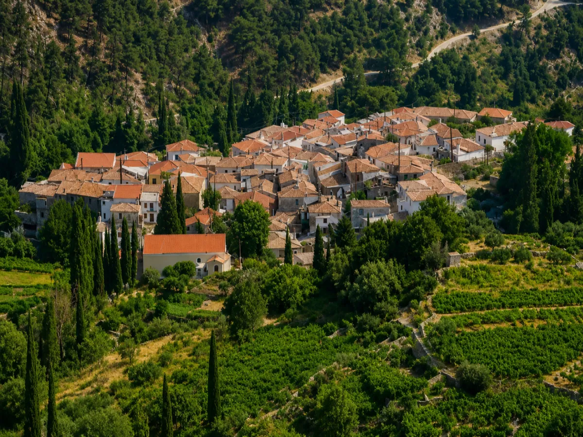
🏡 Pandroso, Samos – A Mountain Village on the Slopes of Karvounis
Pandroso is a mountain village in central Samos, built on the southwestern slopes of Mount Ampelos, also known as Karvounis, at an altitude of approximately 630 metres.
Its uphill lanes, older houses, small neighbourhoods and central square preserve the character of a traditional Samian village. The quiet mountain landscape and the routes leading towards the higher parts of Karvounis are among the main features of the settlement.
According to the 2021 census, Pandroso has 83 permanent residents. It is the administrative seat of the Municipal Community of Pandroso and belongs to the Municipal Unit of Pythagoreio, the Municipality of Eastern Samos, the Regional Unit of Samos and the North Aegean Region.
📍 Location and Character
Pandroso lies near the centre of Samos, on the inland slopes of Mount Karvounis. Its position offers views towards the surrounding peaks, valleys and southwestern mountain slopes.
The village is built on steep terrain, with houses arranged at different levels. Narrow streets follow the natural contours of the hillside and lead towards the square, the parish church and the older neighbourhoods.
Its altitude and distance from the coast create cooler conditions, particularly during summer afternoons and evenings. Clouds and mist can also appear more frequently here than in the coastal areas of Samos.
🏔️ The Mountain Setting of Pandroso
At an altitude of approximately 630 metres, Pandroso lies close to the higher zones of Mount Karvounis, whose summit reaches approximately 1,143 metres.
The mountainous terrain has shaped both the form of the settlement and the traditional activities of its residents. The roads are steep, cultivated land is limited and the surrounding slopes are marked by old stone terraces and retaining walls.
📜 The Shared History with Mesogeio
The history of Pandroso is closely connected with nearby Mesogeio, located approximately 800 metres to 1 kilometre to the south.
The two villages were formerly known as Ano Arvanites and Kato Arvanites and developed as neighbouring settlements with strong family, social and economic ties.
During the period of the Principality of Samos, from 1834 to 1912, they jointly formed the Municipality of Arvanites, whose administrative seat was Ano Arvanites, the present-day village of Pandroso.
The first residents settled in the area during the repopulation of Samos after the middle of the 16th century. Historical accounts differ regarding their origin. Some older sources associated them with Arvanite families, while other studies suggest links with southern Epirus, Attica or Tinos.
📝 From Ano Arvanites to Pandroso
The village was officially known as “Ano Arvanites”. The Community of Ano Arvanites was established in 1918, with the settlement designated as its administrative seat.
On 19 February 1960, the settlement was officially renamed Pandroso and the community became the Community of Pandroso.
The new name is associated with the cool mountain climate and can be interpreted as a place “filled with dew”. The former name Ano Arvanites is still remembered by older residents and people with family roots in the area.
🏛️ Administrative Development
The Community of Ano Arvanites was established in 1918. In 1924, the settlement of Kato Arvanites was temporarily incorporated into it, before becoming the seat of a separate community again in 1928.
Following the renaming in 1960, the Community of Pandroso remained independent until 1997, when it was incorporated into the expanded Municipality of Pythagoreio.
In 2010, it became part of the unified Municipality of Samos and, since 2019, has belonged to the Municipality of Eastern Samos.
👥 Population Development
Pandroso had a considerably larger population in the past, when agriculture, viticulture and livestock farming supported more local families.
In 1940, the village had 661 residents. The population stood at 504 in 1961 and fell to 262 in 1981. In 2001, 166 residents were recorded, followed by approximately 107 in 2011 and 83 permanent residents in 2021.
Despite the gradual population decline, the village remains inhabited throughout the year. During the summer months, people who live elsewhere on Samos or outside the island return to their family homes.
🏡 Traditional Architecture and Neighbourhoods
The architecture of Pandroso is adapted to the steep mountain terrain. In the older part of the village, houses have stone foundations, plastered façades, tiled roofs, wooden frames and small courtyards.
Narrow uphill lanes, stone steps and old drainage channels are characteristic elements of the settlement. Some façades preserve shades of blue, ochre and other earth colours traditionally used in Samian villages.
Limited vehicle traffic within the inner lanes makes it possible to explore the village peacefully and observe architectural details that may be overlooked in larger settlements.
🌳 The Village Square
The square is the main social meeting place in Pandroso. It is paved with stone and shaded by a large plane tree, while the parish Church of Agios Dimitrios stands beside it.
Residents gather here during religious celebrations, cultural events and summer meetings. The square also provides a convenient starting point for exploring the village’s uphill lanes.
⛪ The Church of Agios Dimitrios
The parish church of Pandroso is dedicated to Agios Dimitrios. It is a three-aisled church rebuilt in 1864, during the period of the Principality of Samos.
The church is the village’s most important religious and architectural landmark. Its annual feast is celebrated on 26 October and attracts residents from Pandroso, Mesogeio and other areas of Samos.
Following the religious services, the tradition of offering kiskeki is preserved. This slow-cooked ceremonial dish has deep roots in the festivals and community celebrations of the eastern Aegean.
🕯️ The Mountain Church of Agios Nikolaos
A church dedicated to Agios Nikolaos stands in a prominent position on a rocky hill within the mountainous area of Pandroso.
According to local ecclesiastical tradition, its construction is associated with the appearance of an icon of the saint to a twelve-year-old girl from the area in 1920.
The church celebrates its feast on 20 May and serves as a religious destination within the mountain landscape.
🍇 Viticulture and Agricultural Life
The economy of Pandroso was traditionally based on agriculture, with olives and grapevines among the most important crops.
Cultivation developed on small plots and stone terraces around the village. The steep terrain meant that much of the work had to be carried out manually, from tending the trees and vines to transporting the harvest.
Vineyards and wine remain part of the village’s identity. The Cultural and Improvement Association of Pandroso “Agios Dimitrios” has organised wine festivals with music, traditional dancing and local food.
🫒 Olive Trees and Family Cultivation
Olive trees occupy many of the lower and more sheltered slopes around the settlement. Their harvest remains a seasonal activity for several local families.
Small gardens, fruit trees and crops for household use are also maintained. Although production is no longer as extensive as it once was, agricultural work continues to connect daily life with the changing seasons.
🌿 The Natural Environment
The landscape surrounding Pandroso consists of mountain slopes, low vegetation, woodland, olive groves, vineyards and small streams.
The successive peaks create a peaceful inland environment that differs significantly from the coastal landscapes of Samos.
During spring, the slopes become green and fill with wildflowers. Summer provides cooler hours for walking, while autumn brings softer light and earthier colours to the mountain landscape.
🥾 The Route towards Mount Karvounis
Shortly before the village, an unpaved mountain road leads towards the higher areas of Mount Karvounis. After approximately 5.5 kilometres, it approaches the summit region, while secondary routes continue towards the northern side of the mountain and the areas of Vourliotes and Manolates.
This route should not be treated as an ordinary sightseeing road. Its condition may change after rainfall, landslides or maintenance work, and several sections require a high-clearance or four-wheel-drive vehicle.
Hikers need suitable footwear, sufficient water, sun protection and reliable orientation. Weather conditions in the higher mountain areas can change more quickly than in the lower settlements.
🏘️ The Connection with Mesogeio
Mesogeio lies very close to Pandroso, making it easy to visit both villages during the same journey.
The road between them is steep and winding, with limited visibility in certain sections. Although the two villages have separate parishes and administrative communities, they share a common historical background and strong social connections.
🌿 What to See
During your visit to Pandroso, take time to discover:
✅ The stone-paved square with its large plane tree
✅ The three-aisled Church of Agios Dimitrios
✅ The mountain Church of Agios Nikolaos
✅ The uphill lanes and stone steps
✅ The older houses with traditional façades
✅ The drainage channels along the old streets
✅ The stone terraces surrounding the village
✅ The small vineyards and olive groves
✅ The viewpoints across the slopes of Mount Karvounis
✅ The mountain route towards the higher areas
✅ The neighbouring village of Mesogeio
🚶 The Visitor Experience
A visit can begin at the square and the Church of Agios Dimitrios before continuing through the uphill lanes of the historic centre.
The village can be explored on foot, although the slopes and stone steps require comfortable footwear. Its quiet atmosphere and limited traffic create suitable conditions for photography and observing traditional architecture.
Approximately 60–90 minutes are sufficient for a relaxed exploration of the main points of Pandroso. More time is needed when the visit is combined with Mesogeio or a mountain route on Karvounis.
📆 When to Visit
Spring: The best period for walking, wildflowers and green mountain slopes.
Summer: The village offers cooler afternoon and evening conditions than the coastal areas.
Cultural event period: Summer gatherings and wine festivals bring additional activity to the square.
26 October: The parish Church of Agios Dimitrios celebrates its annual feast.
Autumn: Suitable for quiet walks, agricultural scenery and lower temperatures.
Winter: Additional care is required because of low temperatures, rainfall, mist and possible difficulties on mountain routes.
🧭 How to Get There
The usual road access to Pandroso is through Pyrgos and Mesogeio. The road to the village is paved, uphill and includes numerous bends.
Pandroso lies approximately 20 kilometres from Pythagoreio, 33 kilometres from Samos Town, 23 kilometres from Karlovasi and 20 kilometres from Marathokampos.
The roads within the historic centre are narrow and unsuitable for unnecessary vehicle movement or parking. It is preferable to leave the vehicle at a safe location near the entrance or the square and continue on foot.
ℹ️ Useful Information
✅ Administrative community: Municipal Community of Pandroso
✅ Municipal unit: Pythagoreio
✅ Municipality: Eastern Samos
✅ Population in 2021: 83 residents
✅ Altitude: Approximately 630 metres
✅ Former name: Ano Arvanites
✅ Official renaming: 19 February 1960
✅ Nearest settlement: Mesogeio, approximately 800 metres–1 kilometre away
✅ Distance from Pythagoreio: Approximately 20 kilometres
✅ Distance from Samos Town: Approximately 33 kilometres
✅ Distance from Karlovasi: Approximately 23 kilometres
✅ Distance from Marathokampos: Approximately 20 kilometres
✅ Postal code: 83104
✅ GPS coordinates: 37.7294, 26.8288
✅ Parish church: Agios Dimitrios
✅ Main traditional crops: Olives and grapevines
✅ Road access: Paved mountain road with bends
✅ Mountain route: Unpaved road towards Karvounis, mainly suitable for four-wheel-drive vehicles
✅ Suggested visiting time: Approximately 60–90 minutes
✅ Ideal for: Mountain scenery, traditional architecture, local history, photography and hiking


Add new comment