
Neochori Village – Samos
🏡 Neochori, Samos – The Small Olive-Growing Village with the Taxiarchis Church and Authentic Architecture
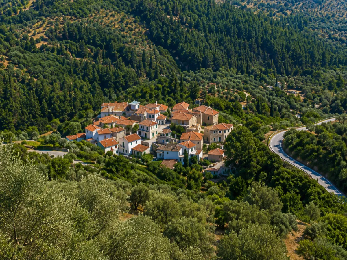
Neochori, known locally on Samos as Nihori or Nihoraki, is one of the island’s smallest villages. It lies in the southern interior of Samos, between Koumeika and Skouraika, at an altitude of approximately 270 metres.
Built on sloping and occasionally steep terrain, the village preserves narrow lanes, old houses, simple rural architecture and attractive views towards the Gulf of Marathokampos and the southern Aegean. Its principal landmark is the historic parish Church of Taxiarchis Michael.
According to the 2021 census, Neochori has 52 permanent residents. Administratively, it forms the Municipal Community of Neochori, which belongs to the Municipal Unit of Marathokampos and the Municipality of Western Samos. The municipality forms part of the Regional Unit of Samos in the North Aegean Region.
📍 Location and Character
Neochori lies on the southern side of Samos, on the southwestern foothills of the Ampelos mountain range, also known as Karvounis. The village is situated north of Skouraika and east of Koumeika, within a landscape of olive groves, agricultural terraces, dry-stone walls, low Mediterranean vegetation and small cultivated areas.
Its position offers open views towards the south and west, over the Gulf of Marathokampos and the islands of the southeastern Aegean. The sloping terrain and natural ravines of the area once helped protect the settlement from direct observation and attacks from the sea.
📝 The Names Neochori, Nihori and Nihoraki
The official name is Neochori, while the local forms Nihori, Nihoraki and the older Samian dialect form Nihourak’ are also used.
The name was not introduced through a modern administrative renaming or as a symbolic new beginning for the village. It reflects the fact that the present settlement became the “new village” that replaced or continued older small residential centres in the area towards the end of the 17th century.
📜 From Zoureika to Neochori
The older name of the area was Zoureika, probably derived from the Zoura family, which was associated with the first residents of the earlier settlement.
During the late 17th and early 18th centuries, residents from Zoureika and nearby small settlements such as Katsoureika, Lazeika and Kaminia gathered at the location of the present village. Neochori gradually developed and replaced, while partly continuing, the older settlement of Zoureika.
🕰️ The Foundation of the Present Village
Neochori is not mentioned in the description of Samos written by Archbishop Joseph Georgirinis during the 17th century, suggesting that the present organised settlement had not yet been established.
By the end of the 17th century, however, a small new settlement had already formed, and the village is mentioned in records from the beginning of the 18th century. Its establishment formed part of the wider process through which small family settlements were concentrated into larger and safer villages following the resettlement of Samos.
📊 Population Development
During the 19th century, Neochori was considerably larger and more active than it is today. The census of 1828 recorded 399 residents, while in 1864 the population reached 436 people, including temporary residents.
In 1886, the village had 482 residents, 145 families and 137 houses. The reference to 137 houses therefore belongs to a historical record from the 19th century and does not represent the documented number of homes today.
During the 20th and 21st centuries, the population gradually declined. The 2001 census recorded 84 residents, the 2011 census recorded 63 and the permanent population fell to 52 in 2021.
🏛️ Administrative Development
Neochori was officially designated as the seat of the Community of Neochori on 21 September 1918.
Under the Kapodistrias administrative reform of 1997, the Community of Neochori was abolished and the settlement became part of the Municipality of Marathokampos. In 2010, it was incorporated into the unified Municipality of Samos and, since 2019, has belonged to the Municipality of Western Samos.
🏘️ The Form of the Settlement
Neochori is a small, organised village rather than an abandoned rural settlement. Its houses are arranged around narrow lanes, small open spaces and the area surrounding the parish church.
Traditional homes survive with stone foundations, plastered façades, tiled roofs, wooden doors and windows and small courtyards. Newer or restored buildings stand among them, although the village’s simple rural character remains visible.
Together with several other settlements of Samos, Neochori was included in 2002 among the areas designated as landscapes of particular natural beauty, with specific architectural rules and restrictions intended to preserve the appearance of the built and natural environment.
⛪ The Parish Church of Taxiarchis Michael
The most important monument in Neochori is the parish Church of Taxiarchis Michael, whose feast day is celebrated on 8 November.
Surviving inscriptions indicate that the church’s first construction phase dates to approximately 1797 and was completed under the master builder Dimitrios. A second building phase, associated with the formation or addition of the narthex, dates to around 1850 and is attributed to the master builder Ioannis Petrou Stamatios.
The church contains an icon of the Annunciation of the Virgin Mary, painted by a priest and iconographer named Georgios and dated July 1799.
🔔 Repairs and the Bell Tower
Several maintenance and extension projects were carried out during the 19th century. Repairs are recorded in 1881 and 1888, with residents taking part and transporting building materials using pack animals.
Construction of the bell tower was approved in 1897 and completed in 1901 on an existing masonry base. Its marble base was built the following year, while the church courtyard was paved in early 1909.
🙏 The Religious Life of the Village
Religious life in Neochori was particularly active during the 19th century. In 1864, records mention eight members of the clergy, one parish church and nine chapels or rural churches in the wider area.
The Feast of the Taxiarchs on 8 November remains the village’s principal religious celebration. The church serves not only as a place of worship but also as the main historic landmark around which the social life of the community developed.
🏺 The Gouva Area and Archaeological Remains
At the location known as Gouva, close to the present village, the historian Epameinondas Stamatiadis recorded remains of an earlier settlement. Farmers cultivating the surrounding fields found roof tiles, ancient objects and architectural fragments.
Among the reported finds was a clay object bearing a circular stamp and the inscription “Hiniochou”. The report is of archaeological interest, but it is not sufficient to determine with certainty the extent, date or character of an organised ancient settlement.
Gouva is not an organised or officially accessible archaeological site. Objects must not be searched for, removed or disturbed on private or agricultural land.
🫒 Olive Cultivation
Olive cultivation has long been the main economic activity of Neochori. The slopes around the village were shaped into terraces bordered by dry-stone walls, allowing cultivation on difficult and relatively poor land.
Olive oil remains the most characteristic product of the area, although it is not accurate to suggest that the village had no other economic activities. In the mid-19th century, records mention thirteen workshops, six olive presses and two mills, indicating a much broader level of economic activity than exists today.
💧 The Watermill of the Monastery of Patmos
During the 19th century, a watermill operated in the Neochori area and belonged to the Monastery of Agios Ioannis the Theologian on Patmos. It was leased to residents or professionals from Samos.
Its existence confirms that parts of the surrounding area had sufficient flowing water to operate a mill and that organised agricultural production required corresponding processing facilities.
💰 Historical References to Economic Hardship
The reference to moneylending comes from a historical description by Epameinondas Stamatiadis concerning the condition of the village during the late 19th century.
The decline in population during the 20th century was more broadly connected with migration towards urban centres, changes in the rural way of life, limited employment opportunities and the gradual depopulation of small mountain and semi-mountainous villages.
🌿 The Natural and Agricultural Landscape
Olive groves, terraces, dry-stone walls, low vegetation and old rural tracks dominate the landscape around the village. Unlike the more densely forested villages of northern Samos, the surroundings of Neochori are drier and more open.
The terrain creates panoramic viewpoints towards the Gulf of Marathokampos, Ikaria, Fournoi, Patmos and the smaller islands of the southern Aegean when visibility is clear.
🌿 What to See
During your visit to Neochori, take time to discover:
✅ The parish Church of Taxiarchis Michael
✅ The historic bell tower of the church
✅ The central area around the church
✅ The narrow lanes and old neighbourhoods
✅ The traditional houses with stonework and tiled roofs
✅ The old rural homes and storage buildings
✅ The dry-stone walls and cultivated terraces
✅ The olive groves surrounding the village
✅ The viewpoints overlooking the Gulf of Marathokampos
✅ The old routes towards Skouraika and Koumeika
✅ The wider landscape of the Gouva area, without entering or disturbing agricultural land
🚶 The Visitor Experience
A visit can begin at the Church of Taxiarchis Michael and continue through the narrow lanes of the small village.
Neochori is not a destination with a large number of organised attractions. Its value lies in quiet exploration, the traditional scale of its buildings, the views and the experience of the agricultural landscape of southern Samos.
Approximately 45–60 minutes are sufficient for a basic walk through the village. More time is needed for photography or exploring the surrounding rural roads.
📆 When to Visit
Spring: The best period for flowering landscapes, mild temperatures and clear views.
Summer: Morning or late afternoon is preferable, as the landscape is relatively open and shade is limited.
Autumn: Suitable for peaceful exploration and for seeing the agricultural surroundings before or during the olive harvest.
8 November: The Feast of the Taxiarchs and the parish church.
Winter: The village is particularly quiet, but care is required on the road during heavy rain or fog.
🧭 How to Get There
The most direct access is from the road towards Skouraika. Approximately two kilometres before Skouraika, a junction leads to Neochori after a further distance of around 1.7 kilometres.
The road is paved, but the final section includes bends and areas of limited width. An off-road vehicle is not required, although careful driving and low speed are advisable.
There is also a road connection towards the Koumeika area through the local road network. Neochori lies approximately 13 kilometres from Marathokampos, 16–18 kilometres from Karlovasi, 23–24 kilometres from Pythagoreio and 36–37 kilometres from Samos Town.
ℹ️ Useful Information
✅ Official name: Neochori
✅ Local names: Nihori, Nihoraki, Nihourak’
✅ Earlier residential centre: Zoureika
✅ Character: Small semi-mountainous agricultural village
✅ Location: Southern Samos, between Koumeika and Skouraika
✅ Administrative community: Municipal Community of Neochori
✅ Municipal unit: Marathokampos
✅ Municipality: Western Samos
✅ Regional unit: Samos
✅ Region: North Aegean
✅ Official establishment of the community: 21 September 1918
✅ Population in 2021: 52 permanent residents
✅ Population in 2011: 63 permanent residents
✅ Population in 2001: 84 residents
✅ Historic population in 1886: 482 residents
✅ Altitude: Approximately 270 metres
✅ Principal church: Taxiarchis Michael
✅ Initial construction phase of the church: Approximately 1797
✅ Feast day: 8 November
✅ Principal traditional activity: Olive cultivation
✅ Historic facilities: Olive presses, mills and workshops
✅ Area of archaeological interest: Gouva
✅ Area designation: Landscape of particular natural beauty
✅ Distance from Marathokampos: Approximately 13 kilometres
✅ Distance from Karlovasi: Approximately 16–18 kilometres
✅ Distance from Pythagoreio: Approximately 23–24 kilometres
✅ Distance from Samos Town: Approximately 36–37 kilometres
✅ Postal code: 83104
✅ GPS coordinates: 37.7080, 26.7718
✅ Road access: Paved road with bends
✅ Organised parking area: None
✅ Tourism facilities: Very limited
✅ Suggested visiting time: Approximately 45 minutes–2 hours
✅ Ideal for: Traditional architecture, history, photography, agricultural landscapes and peaceful exploration



Add new comment